


A few km further down the trail we had a 5 km detour where the dike is being raised higher. The sea looks far away and calm, but when just the right, or to be more precise just the wrong, conditions conspire together, the result can be lethal. We passed a monument with some of the evidence: 1362, the Saint Marcellus flood, thousands dead. 1570, the All Saints Day flood, 100,000 dead. The 1717 Christmas Day Hurricane (actually a 3-day event), 15,000 dead. As recently as 1962, a flood in this area killed 312 people. They're not taking any more chances.
Bremerhaven is a busy port. Even though Bremerhaven is 100 km from Bremen, Bremerhaven was created by Bremen and is part of the city-state of Bremen, and the ports of the two localities are considered two halves of the same whole, "the Port of Bremen." It is the second-busiest port in Germany after Hamburg, both in gross tonnage and in the number of containers handled. As we biked in through the port area -- one of the busiest and least bike-friendly places we've been through in Europe so far -- we stopped to view the port from the Container Viewpoint. It's actually a tower made from used shipping containers, and it did in fact give us a viewpoint over part of the container port. The red and white ship to the left of the tower in the first photo is going through the locks as it exits the port for the open sea, and provided us with a close-up sense of how big these monster ships are.


Bremerhaven was the point of departure for over 7 million folks in the period from the 1830s to the 1960s, as they left Europe for new lives elsewhere. Most went to the U.S. and Canada, but other large numbers went to various points in South America and Australia. To recount the story of this mass emigration, the Auswanderhaus Museum (Emigration Museum) opened its doors a dozen years ago. The story was told in a dramatic way by recreating images you could interact with in a visceral way. In the first room you enter, emigrants are waiting at the dock, dressed as they were at different periods, such as the 1840s or the early 1900s. In the third photo, for example, the clothing worn by the man and boy on the right shows that they are probably among those escaping Europe after WW II. In addition, an electronic stick with a small speaker in it that they handed us upon entry to the museum allowed us to press a button on various figures on the dock and hear them speaking low German, high German, Polish, Russian and more.


You could freely walk among the "emigrants." Two rooms later we walked down a ramp and then up the gangplank and could wave 'bye to this same polyglot crowd on the dock below.

 Inside the "ship" we passed some of the luggage that contained the handful of items the emigrants took with them to their new worlds. One was a comb with a story. It was meant for combing a horse. A father gave it to his departing daughter, certain she would marry a cowboy in America, because there were so many of them there -- he had read so many stories about them. She did get married, but to a baker in New York, and she used the brush instead to sweep flour off the table where they made bread and pastries.
The next part of the story was about sleeping accommodations. In three life-sized displays we saw the third class quarters of a ship in the 1840s, with a soundtrack in the background of people coughing and occasionally groaning. Next, a ship from the turn of the 20th century, with a background of snoring, presumably from the character in the foreground. The third one was from a ship in the late 1920s or 1930s, when third class quarters meant four to a cabin, but nonetheless a big improvement from the earlier times.


As we moved along there were also multiple places to learn about one of the 15 specific individuals they have chosen from the 7 million who came through. Jeff was assigned Carl Laemmle, and at various stations he could use his listening stick to learn more about him, and/or about any of the other 14. At the outset, Laemmle was just another teenager fleeing poverty in Germany. In the end, he was the owner of a major Hollywood studio and a major player in the American film industry in the 19-teens, '20s and '30s.
Although the large majority of emigrants traveled as cheaply as possible, there were always some who made the journey in style. Images from the times helped display the travel experience for these privileged few in different ways, and in different eras.


It was a well-spent few hours exploring this wonderful museum!
Our journey up the Weser began with a journey across it by ferry, for the official Weserradweg stays on the western (left) bank all the way up to Bremen, even though Bremerhaven is completely and Bremen mainly on the eastern side of the river. This ferry trip gave us a view of the waterfront. There are a number of new buildings in the heart of the city, which has been seeing a resurgence in recent years. The port begins just north of the center of the city, to the left in this photo. With the telephoto lens looking even further left/downstream in the following photo, you can see the container port and a cruise ship docked for the day at the near end of the container port. With all that activity, you can see why it was so challenging two days earlier for us to make our way along the shore, dodging trucks, cars, taxis and railroad cars coming and going from the port.


The Weserradweg was created a little over 25 years ago by connecting up a continuous route for bikes along one bank or the other of the river. Most of it was car-free bike trails, but occasionally it took us onto very low-traffic streets. Occasionally the paving was bricks but at least 90% was very smooth asphalt. In the first photo we're passing by some thatch houses, both us and the houses hiding behind the tall river dike. The second photo is one of many places where we hopped over the dike and also in this case the railroad. A Deutsches Bahn train zipped by as we headed at a more measured pace down to a riverfront section of trail. In the third photo we are right on the river in front of the dike. This 4-km part of the trail looked to us to be recently built, and also looked like there better be an alternate route behind the dike, because there will be days when the Weser will be much higher than this part of the trail (every now and then you pass poles with marks on them showing how high the water reached in various flood years, and many of these are higher than the trail but not the dike).


In the 100 km from the sea at Bremerhaven to the city of Bremen, there are no bridges and only one quite busy tunnel that does not, for good reason, allow bikes. The river is tidal the whole way, and you can see exposed sandy banks in the first photo, taken at mid-tide. There are a number of ferries in this stretch, in addition to the one at the mouth of the Weser that we took upon leaving Bremerhaven. One was next door to a hotel we stayed at, near the mid-point between the two cities, and diners at the outdoor terrace restaurant there had a source of steady entertainment.


On the second day we encountered a viewpoint tower which was heavily visited by cyclists like ourselves. As you can see in the views from the tower, the river here is more utilitarian than scenic. The two day ride to Bremen was not at all unpleasant, and in fact interesting and scenic in small doses, but all in all not something we would choose to return to do.


 If the name "Bremen" triggers some response in you, our readers, perhaps it is in part due to the Brothers Grimm. When they collected various stories and legends from central Germany 2 centuries ago, one of these "fairy tales" was called The Town Musicians of Bremen. It tells of a donkey, a dog, a cat and a hen that have become old enough to be of no further use to their masters. Fearing the worst, they decide to go to Bremen, famous as a "free" city because it was ruled by its citizens (albeit a very limited number of them until the 19th century), and not by some local member of the aristocracy. They come upon a house that robbers have broken into, and decide to sing. Their raucous sound scares off the robbers. The robbers return in the night and the chicken scratches him, which he interprets as the scratches of a witch. The donkey hits him in the head with a kick, which to the robber is being clubbed by a giant. And so on. The robbers flee, and the animals live on in the cottage happily ever after.
 In the story the animals never actually reach Bremen, but you wouldn't get that impression today. They have reached it in force. The most famous sighting one gets is next to the town hall, up above. But there are donkeys, dogs, cats and chickens to be found all over town. Our favorite was the one of them at night.


 We spent three nights in Bremen to give ourselves the chance to see this famous city. Our first stop was a little alley, Böttgerstraße, running from the Weser two blocks to the market square. It has one medieval building, shown in the first photo. In the 1920s the rest of the street was developed in an art deco style that also, somewhat, blended in with the original occupant. Because of the narrowness of the alley and its twists and turns, it has a very special charm. Because of its location, it is always filled with tourists. Outside a small art museum was yet another representation of the Town Musicians, but only three were present. A sign explained that the rooster was "much loved" and had been broken off and stolen so many times that the latest iteration of him was on view inside the museum, where he is much safer from his "fans."

The market square is one of the most beautiful we have yet encountered. The large building on the left of the first photo was built in 1538. The next photo zeros in on the elaborate decoration above the main entrance. The Rathaus (city hall) in the third photo has already had its 600th birthday, although the exterior is "only" about 400 years old since its last remodeling. The spire is on a church which is actually behind and to the left of the Rathaus itself. The last photo displays some of the detail work on the city hall's facade.


 That Bremen is as beautiful as it is is something of a surprise, given its fate in WW II. Because of its extensive docks, a nearby aircraft factory, and its position as one of the closest large German cities to the British and American airfields in East Anglia, it was attacked by bombing raids over two dozen times in the war. As we walked through the city we came upon a sign that reproduced one of the photos taken by Allied photo-reconnaissance. Though the military targets were where the bombs were supposed to land, many raids dropped their bombs through clouds that left the bombers uncertain where the bombs were actually falling. They did succeed in hitting the docks many times and even damaging U-boats being worked on there, as well as the airplane factory, but much else was destroyed as well. You wouldn't know it to walk around the Old City today.
 Fighter planes and anti-aircraft guns were the defensive means of choice in that war. In far earlier times, water was a major player. From a screen shot of Google Maps in satellite view you can see how the Bremeners built a moat of sorts around the medieval city, now of course only the core of an enormous city of over half a million, and used the Weser itself to protect it on the southwestern side. Today that moat is the centerpiece of a city park where ducks have been provided with homes and cyclists a place to sit and daydream. A "Dutch" windmill completes the illusion of rusticity.


 One part of the old city did escape serious damage in the war, an area called "The Schnoor." It almost suffered damage just as severe in the 1970s when developers started suggesting it be torn down and "modernized." Urban activists saved it, and today it too is a favorite tourist destination for its many narrow streets and alleys, its shops and cafes. We chanced upon a guide giving a tour in English long enough to hear a story about a Canadian tourist of substantial girth who was told he "could NOT" walk down the narrowest alleyway in the Schoor. He considered this a challenge rather than a command, and headed straight for it. After a 2 or 3 hour effort by the Bremen Fire Department to extricate him, he was given a bill for their many man-hours of work.
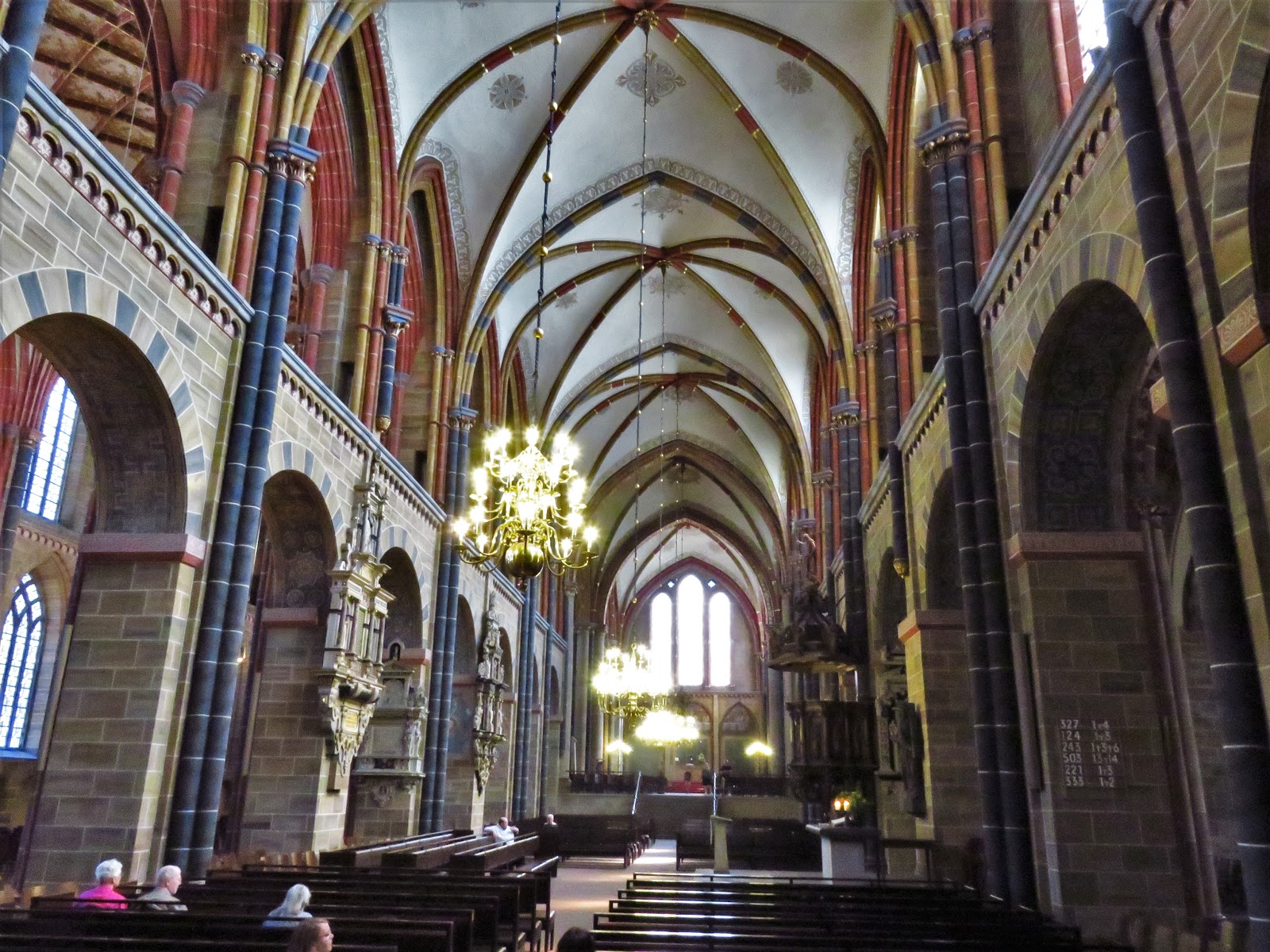
 Back in the heart of the Old Town there was one more challenge, the 250+ steps to the top of the Domturm, the spire of the cathedral of St. Peter. The view was spoiled somewhat by the wire cage, presumably to keep tourists from climbing out and down the outside of the tower. The view also somehow lacked points of interest worth pointing the camera towards, and the views of the Weser were fleeting. The cathedral itself was attractive though.
All that sightseeing on foot had taken up a long day. We considered walking in to the heart of the city the next day to see a renowned art museum, but the weather was so enticing we chose instead to ride to the city of Worpswede, about 25 km to the east. Since our bike guide to the Weserradweg did not extend that far away from the river, we downloaded maps to our Mini-iPad using Google Maps and opencyclemap.org. We only took one seriously wrong turn that added 6 km, and we really enjoyed the different feeling of riding Little Red without luggage, especially since there were a few hills on the way. But the town was a little disappointing. It's touted as an "artsy" community, but unless you pay to enter the various art galleries, there's not much to see. The largest piece of public art, a 3 km ride out of town, was the Niedersachsenstein, or Lower Saxony Stone. It's meant as a memorial to soldiers from Lower Saxony who died in WW I. It came off as obscure and bombastic. In a field nearby, however, we did get one amusing "self-portrait" of Jeff thanks to another piece of public art.


Jeff's not looking up the Weser in that view, but that's where we head next, toward Hamelin, another city made famous by the Brothers Grimm.

No comments:
Post a Comment