
As
explained also in an earlier blog entry, an American who enters the Schengen
Zone may spend only 90 out of the next 180 days there. Most of the EU is in the Schengen Zone, but
luckily not the UK, so we headed there in late July to stop the Schengen clock
for 19 days.
 Our
room on the Stena ferry was "cosy," as in "tiny as a postage
stamp but comfortable if you didn't swing your arms too wide." Plus we were going to British time, meaning
we gained an hour. We headed upstairs to
enjoy a full moon and the last views of Holland to the east, then beaches and
dunes stretching endlessly off to the north at the mouth of the Rhine, and
finally sunset. England was now just 6
1/2 hours beyond the end of that lengthy jetty.
Our
room on the Stena ferry was "cosy," as in "tiny as a postage
stamp but comfortable if you didn't swing your arms too wide." Plus we were going to British time, meaning
we gained an hour. We headed upstairs to
enjoy a full moon and the last views of Holland to the east, then beaches and
dunes stretching endlessly off to the north at the mouth of the Rhine, and
finally sunset. England was now just 6
1/2 hours beyond the end of that lengthy jetty.


When the
loudspeaker in our stateroom woke us from sound sleep at 5:30 am, however, it
didn't feel like we had crossed the Channel or "gained" a minute, let
alone an hour. When your optic nerve
transmits "5:30" to your brain, no other part of that organ is strong
enough to say it "feels" like anything other than "Hey, this is waaaay too early to function!"
But
function we did, sort of, and 75 minutes later we rode off the ferry and
through British customs onto our first British road. "Dang" (or something like that),
our rear view mirrors are on the wrong side!
Louise's is designed to be left-side or right-side, but not Jeff's, so
we stopped to move hers and jerry-rig his to give him a view back, kind of sort
of, but only if he leaned just so, and didn't expect to see back
more than fifty feet. Like the little
engine that went down the track saying "I think I can, I think I can, I
think I can," Jeff steered down the road saying his own mantra quietly to
himself: "you're in bloody Britain, bike on the left; you're in bloody
Britain, bike on the left; you're in bloody Britain, bike on the
left." We explored the harbor town
of Harwich, tracked down an ATM and armed ourselves with some British pounds,
then headed west toward Dedham, our first destination.
We had a
mostly quiet route Jeff had found mapped out on the Internet, but there were a
few stretches of a mile here, two miles there on busier roads. Narrow busy roads, with Jeff busy reciting
his verses and counting down the tenths of a mile on the bike computer, waiting
'til we came to a turn into one of those quiet roads. Then, "oh, no!" from Louise
followed by a plastic-y bouncing sound.
"Stop, the mirror fell off!"
We pulled
left to the edge of the road and looked back at a line of five cars that had
been trailing us, and at our mirror in the middle of the lane. A car straddled it. Whew.
Another. Whew again. A third.
Yeah, there's hope! Nope. Number four nailed it with his left tires,
thinking he was doing a good thing by passing us with extra room. Number five completed the flattening. Memo to selves: search for "bike
shop" along our route on Google
Maps tonight.

 Somehow
we survived and were rewarded a few miles out of Dedham with our first grand
view of "Constable Country."
Across the valley is East Bergholt, where John Constable grew up, and on
the left (just right of the large tree) you can see the square tower of Dedham
Church, which appears in a dozen or more of his paintings. After a nice coast
downhill, we found ourselves in town and in front of that very church, then
soon after in our 16th century lodging for three nights, Dedham Hall, built in
the reign of the first Queen
Elizabeth.
Somehow
we survived and were rewarded a few miles out of Dedham with our first grand
view of "Constable Country."
Across the valley is East Bergholt, where John Constable grew up, and on
the left (just right of the large tree) you can see the square tower of Dedham
Church, which appears in a dozen or more of his paintings. After a nice coast
downhill, we found ourselves in town and in front of that very church, then
soon after in our 16th century lodging for three nights, Dedham Hall, built in
the reign of the first Queen
Elizabeth.

 Having
been spoiled for 6 weeks by Holland's and Belgium's fabulous bike
infrastructure, we had a hard adjustment to England's narrow roads and almost
total absence of bike paths or even bike lanes.
But in the next two days we began to see that England is as far ahead in
walking facilities as the Low Countries are in biking. From Dedham Hall we could walk straight down
paths that were public ways even before that manor house was built, and have
remained so ever since. Here are just a
few of the paths that we walked, the first of many that we discovered
criss-crossing every village we visited in East Anglia. Most had either stiles or gates to keep the
cows or sheep where they belonged while letting people pass through, while
others went right through fields of crops (rutabagas, we think).
Having
been spoiled for 6 weeks by Holland's and Belgium's fabulous bike
infrastructure, we had a hard adjustment to England's narrow roads and almost
total absence of bike paths or even bike lanes.
But in the next two days we began to see that England is as far ahead in
walking facilities as the Low Countries are in biking. From Dedham Hall we could walk straight down
paths that were public ways even before that manor house was built, and have
remained so ever since. Here are just a
few of the paths that we walked, the first of many that we discovered
criss-crossing every village we visited in East Anglia. Most had either stiles or gates to keep the
cows or sheep where they belonged while letting people pass through, while
others went right through fields of crops (rutabagas, we think).


One of
these walks brought us to East Bergholt, where John Constable was born down the
street from this ancient church, and to Flatford Mill where Constable's father
ran a mill.


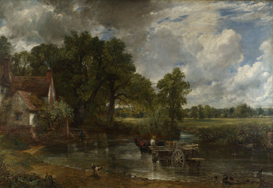

and View on the Stour in 1822. The bridge is new -- wooden bridges rarely
last 200 years -- and some trees have grown up to the left, but even in
Constable's day the view in the painting was not what the eye would have
perceived there. The church was further
to the left, out of view, and rather small as it is four miles away (we had to
use the telephoto lens aimed 30 degrees to the left to find it from a nearby
viewpoint), so Constable moved it, as it were, some two miles to where he
preferred it were located. He also
thought that Willy Lott's roof was too long in The Hay Wain, and you might have noticed above that he shortened it
up a bit. Imagine that, all this without
Photo Shop!


About a
fourth of the way on this 43-mile day we reached National Bike Route 1, and
followed it for the next two days. This
is one of a few dozen cycling routes that have been mapped out to string
together low-traffic routes around the country.
Once we got the hang of it plus some good maps, these made the biking
better, and route-finding much simpler, since we now had a bright blue icon to
search for on direction signs at intersections.
Nonetheless, we were still on narrow roads, just ones with very light
traffic on them.

 A
short digression: Henry VIII named his
son Edward VI as his successor, with Henry's daughters Mary and Elizabeth as
next in line if Edward didn't produce an heir.
As Edward lay dying, heirless, he tried to change things about and named
Lady Jane Grey, a more distant Tudor relative, as the next queen. Mary thought otherwise, and gathered troops
at Framlingham Castle, prepared to fight her way to London to claim her throne. Parliament knew how to count soldiers, and
threw its support to Mary. Framlingham
Castle is still there, but that moment in 1553 was its high point and its last
moment of military significance. From
the outside or from atop its ramparts, it's an imposing sight with impressive
views.
A
short digression: Henry VIII named his
son Edward VI as his successor, with Henry's daughters Mary and Elizabeth as
next in line if Edward didn't produce an heir.
As Edward lay dying, heirless, he tried to change things about and named
Lady Jane Grey, a more distant Tudor relative, as the next queen. Mary thought otherwise, and gathered troops
at Framlingham Castle, prepared to fight her way to London to claim her throne. Parliament knew how to count soldiers, and
threw its support to Mary. Framlingham
Castle is still there, but that moment in 1553 was its high point and its last
moment of military significance. From
the outside or from atop its ramparts, it's an imposing sight with impressive
views.


The
castle had a helpful sketch showing what it might have looked like in the
1200s. By the 1700s the church (to the
right) and manor house (to the left) had been dismantled, leaving just a few
tell-tale marks on the castle wall that they had once been there. Meanwhile a self-made tycoon bought the place
and provided funds for a poor house to be constructed within the castle, with
provisions that youngsters living there be provided with useful trade skills. Historians think that handsome carvings over
the doors and windows of the poorhouse were recycled from the former manor
house.


We spent
a few wonderful hours exploring Framlingham Castle and learning how theses
seemingly solid structures constantly changed with the times. Before leaving we saw one of the newer
innovations there, Boot Camp Day for kids, where a gruff sergeant shouted out
encouragements like "move along, my granny can do that faster than you're
doing it!" The kids seemed to love
it.


 We
had booked three nights in Wroxham in an area known as The Broads, famous for
tidal rivers with broad sections in former peat bogs. Alas, it was quite windy both days we had
planned for canoeing or biking, so instead we took a train each day 30 minutes
north to Sheringham, on the Norfolk coast.
Good call, as the info center provided us with a detailed map that led
us both days on some great walks.
We
had booked three nights in Wroxham in an area known as The Broads, famous for
tidal rivers with broad sections in former peat bogs. Alas, it was quite windy both days we had
planned for canoeing or biking, so instead we took a train each day 30 minutes
north to Sheringham, on the Norfolk coast.
Good call, as the info center provided us with a detailed map that led
us both days on some great walks.
Two days
earlier we had photographed this stunning flint house in Beccles. Flint must be quite abundant in these parts,
as we saw many homes throughout East Anglia made from it, but none as stunning
as this one. It was made with cut flint,
in this case almost perfect hemispheres with the flat surfaces facing
outward. A similar style we encountered
was with cut flint, but with irregularly cut surfaces facing outward.

 That same
earlier day we had also biked past the ruins of a church from Norman times that
illustrated the third and most common style we saw, entire structures made of
uncut round flint stones held together with a minimum of cement.
That same
earlier day we had also biked past the ruins of a church from Norman times that
illustrated the third and most common style we saw, entire structures made of
uncut round flint stones held together with a minimum of cement.


 Our two
walks from Sheringham also took us down paths tucked between hedge rows, past a
country manor once owned by the local gentry, and on to sweeping vistas. A steam train chugged by, full of tourists, a
windmill out their right-hand windows.
We walked a mile further to one of the steam train's railway stations
and its much needed WC, which was decorated with old train posters.
Our two
walks from Sheringham also took us down paths tucked between hedge rows, past a
country manor once owned by the local gentry, and on to sweeping vistas. A steam train chugged by, full of tourists, a
windmill out their right-hand windows.
We walked a mile further to one of the steam train's railway stations
and its much needed WC, which was decorated with old train posters.


 To
maximize occupancy in the dormitories, they installed these trapezoidal
beds. To keep idle hands from doing the
devil's business, they provided work, such as in the laundry with these washers
and drying racks. It was all quite
Dickensian.
To
maximize occupancy in the dormitories, they installed these trapezoidal
beds. To keep idle hands from doing the
devil's business, they provided work, such as in the laundry with these washers
and drying racks. It was all quite
Dickensian.

Castle Acre was our favorite town in East Anglia, partly for the good food and charm of the Ostrich Inn, but mainly because it had not one, nor two, but three ancient sites, along with being an attractive little town.


The real
jewel of Castle Acre, however is the Priory, the best-preserved Cluniac
monastery in England. The Cluniacs were
sort of the Lexus brand of monasteries, renowned for their elegance and
style. Just check out that
Reredorter! They somehow found a letter
written home to mom and dad by a young monk, who just gushed about how they
didn't have a hole in the ground, his monastery had this wonderful two story
building, and when you went the water just washed it all away! They haven't yet come across any letters from
the folks living downstream. Oh, did we
mention, this place once had 35 well-fed monks living here?


En route to Ely we planned to visit one of England's stately homes now open to tourists, when we chanced upon one that is clearly still private. Hmmm, didn't Darcy from Pride and Prejudice have a place up in Norfolk, where we now were? There was no mailbox with a name on it to say otherwise. In due time we got to our true destination, Oxburgh Hall in the town of Oxborough, and it was a stately home indeed. A stately moated home, in fact, with a rather imposing entrance across that moat through the tower and into the inner courtyard.


In
exchange for a few pounds sterling we got to poke about the place, see the sort
of stuff the British nobility tended to accumulate over the centuries, and to
walk through one room that made us think that Lord Grantham and Lady Mary might
walk in at any moment to try some of that pot of tea and plate of crumpets.


 The most
remarkable feature of the house, however, is the "priest's
hole." The Bedingfields never gave
up their Catholic faith when England became a Protestant country, and being a
Catholic priest there see-sawed between being a deportable offense and a
capital one. Several dozen noble
families around England like the Bedingfields shielded Catholic priests, but even
they could not openly defy the law so they evaded it by having secret places
the priest could hide in when the law came by for a spot of tea and an
unannounced inspection. This one was in
the back of a closet, and is apparently one of the best priest holes to survive
and be open to the public. Thanks to
their Catholic connections, the Bedingfieds also came into possession of some
very fine needlework done by Queen Elizabeth's feisty Catholic challenger, Mary
Queen of Scots, during Mary's long captivity.
The most
remarkable feature of the house, however, is the "priest's
hole." The Bedingfields never gave
up their Catholic faith when England became a Protestant country, and being a
Catholic priest there see-sawed between being a deportable offense and a
capital one. Several dozen noble
families around England like the Bedingfields shielded Catholic priests, but even
they could not openly defy the law so they evaded it by having secret places
the priest could hide in when the law came by for a spot of tea and an
unannounced inspection. This one was in
the back of a closet, and is apparently one of the best priest holes to survive
and be open to the public. Thanks to
their Catholic connections, the Bedingfieds also came into possession of some
very fine needlework done by Queen Elizabeth's feisty Catholic challenger, Mary
Queen of Scots, during Mary's long captivity.

 From
crypto-Catholicism we moved on to soaring Anglicanism as we visited a second
great cathedral, Ely. Its finest feature
is the Octagon, a domed structure built in 1532 over the crossing, i.e. the place where the long E-W axis
of the church intersects the shorter N-S arms.
But Ely had many smaller charms, like these stone carvings where monks
once entered the church from their attached cloister.
From
crypto-Catholicism we moved on to soaring Anglicanism as we visited a second
great cathedral, Ely. Its finest feature
is the Octagon, a domed structure built in 1532 over the crossing, i.e. the place where the long E-W axis
of the church intersects the shorter N-S arms.
But Ely had many smaller charms, like these stone carvings where monks
once entered the church from their attached cloister.


It was
now our twelfth day of cycling in England.
We did a mile or two on a dike path near Ely, then headed back into the
rolling hills through Suffolk past a charming country house. We reached the town of Long Melford about 4
p.m. Waiting for us in a rented cottage
were Lin and Bernard, a British tandem couple we met in 2009 in New
Zealand. We'll tell you about our week
with them, exploring this corner of Suffolk on foot and on tandems, in our next
blog entry.


