We ended our last post of 2019 with this hopeful note: "We hope to be doing this yet again next Summer, most likely in the Netherlands."
And as 2020 began, we began planning for just that.
Oh my . . .
Well, as we all know, it's been a very different year than anyone expected. We were putting the finishing touches on our trip planning, 87 nights in the Netherlands and 2 in nearby Aachen, Germany, when our home town of Seattle became ground zero for the coming storm of the Covid-19 pandemic.
The good news is that we were able to cancel our flights to and from Europe and the 75+ nights of lodging we had just booked, although with long delays getting our money back. But back it came.
What now? For 13 years we have gone without an automobile, relying on our bikes, our feet, buses, trains, and even the occasional rented car for a fun weekend out of town. With the pandemic, none but the bikes and the feet were safe, and then only with care to keep distant from others. We managed, but our walks were always out-and-back within a 3 or at most 4 mile radius of home. Since we live in the Ballard neighborhood of Seattle on the edge of Puget Sound, hemmed in by it to the west and by the Ship Canal that cuts across Seattle to the south, the area we could explore on foot and without taking a bus was very, very limited. We got to know it far too well.
On the tandem we could of course go further, but Seattle is a hilly place. Rome notoriously has 7 hills, and that led many in early days to refer to the Seven Hills of Seattle, but depending on whom you ask it's actually anywhere from 10 to 15 places worthy of the title. 4 of them are over 450' (140 m), and none of those is terribly far from Puget Sound, elevation zero. So biking tends to follow certain routes that avoid these topographic challenges as well as those created by motor vehicle traffic, and that somewhat limited the variety we could build into our biking program.
Indeed, the first and last 4 miles of 90% of our rides followed the exact same escape route from our perch on Puget Sound. It's a nice route, half of it on the fabulous Burke-Gilman Bike Path, but it's still the same route, again and again and again. And while we could obviously go further by bike, we still couldn't get out of the city itself and make it home the same day, so rides in the more open and leafy areas just outside the city like the Sammamish and Green River Valleys were not an option.
And that is when we decided to look for a car. At the end of May be purchased a new 2019 KIA Niro, a hybrid car that has been getting ~45 mpg (19 km/l) for the six months we've now owned it. One of the first things we did next was to purchase a car-top rack on which to mount the Tandem Topper bike carrier we've stored for the past 13 years. That done, we began the first of several trips where we drove 15-20 miles from home and then started biking, exploring both old favorites such as the aforementioned valleys, plus tracked down several obscure bike trails we'd never explored before and added them to our mental database of interesting places to bike in the Seattle area.
And THEN we said to ourselves, "You've now got a rack on your car, why not get a canoe to put on top of that rack?" Why not, indeed. With perseverance and the assistance of Craigslist.com, we finally found someone 100 miles away who was selling an Old Town 16' canoe for about 1/3 of its cost when it was new a decade ago. It had some gouges in the royalex skin that Jeff fixed with $10 worth of marine putty and prettied up with a little spray paint to cover the repairs, and we now had ourselves a terrific boat. More about it shortly. The irony created by the pandemic is that buying a car enabled us to be more active by giving us access to more interesting places outdoors to stay active.
So, how have we done staying active during this challenging time? Overall, pretty good we think. We focused not on the places we no longer could go visit, but rather on local ones we could discover anew and with closer looks. For years we have indulged our obsessive-compulsive tendencies by tracking our walking and biking miles, and programmed an Excel spreadsheet to see if we're staying above our goal of 5 miles of walking per day (factoring canoeing at par and 5 miles of biking to equal 1 mile of walking). This is roughly the same goal as 10,000 steps, a common goal for fitness enthusiasts. As we close out 2020, we have in fact met our goal once again, and are only slightly lower than in the past few years. We're chalking up that small decline to minor limitations imposed by the coronavirus, of course, and not at all to being in our "declining years."
It helped immeasurably that we are fortunate to live in an interesting location, on the shore of Puget Sound just south of the Shilshole Marina (the largest one in Seattle with berths for over 1,400 boats). Our condo unit overlooks the marina, and the condo development has a private gate to a pier that you see in the foreground of the photo below, taken on one of our rare but exciting foggy mornings. That pier connects to a mile-long walkway the length of the marina. From there the path continues another half-mile through Golden Gardens Park, where a freshwater pond next to the beach is both a turn-around spot plus a place to check out the resident turtles and ducks. When the weather was "iffy" we could, and did, do this walk for a pleasant hour-long stroll, with an eye on the clouds to the west to be sure we could scurry back if need be.
Another common walk went to Golden Gardens Park, then climbed 325 feet (100 m) up the steep bluff to a wonderful lookout. That's our condo just beyond the marina. We did this 5-mile walk so often we came up with variants, zig-zagging different streets on the descent through a residential area until we had walked virtually every block in a 50-block area. When that was old hat Jeff printed a map of the neighborhood showing the estimated value of each house near the edge of the bluff, and we took turns guessing what Zillow thought certain ones would sell for. Needless to say, houses with some sort of view of Puget Sound were $50-100,000 pricier than similar houses a block or two away, while houses with spectacular views like this one could add multiples of that to the selling price. Other walks combined utility and exercise, as we walked to the public library when it finally reopened for pick-up only (we could reserve books and dvds online and select our local branch for pick-up). That was a 4-mile walk without detours, and once again we alternated our route each time until there was no block we had not perused in that entire part of Ballard as well. Since this area is residential and the streets do not lead to other neighborhoods, walking was particularly safe. On the few occasions, maybe once each ten minutes of walking, that someone was walking toward us on the sidewalk, either we or they would simply step out into the street or to the sidewalk on the other side. Car traffic was so light that we almost never had to pause to let one by. Stay six feet away? We rarely came within ten feet. And of course we had our masks to slip on if we saw a close encounter coming.
Another destination was a fruit and vegetable stand that was a 5-mile round trip, and on one occasion we packed a picnic lunch and ate it at a tiny park on the way there. It's called Ballard Corners Park, and occupies a parcel of land that once held 2 houses and a corner grocery store. Jeff is enjoying a Vietnamese bun lunch we picked up on the way. As you can see, our lunch table recreates a soda fountain the store once had, and signs on the table and in the display to his right told the story of Ballard's corner stores a century ago, when people obtained their groceries by walking to the nearest small market, almost always on a corner, and supermarkets were a thing unknown.
As the the Great Toilet Paper Shortage of 2020 ended and the weather warmed, both unconnected but happy events, we were able to have picnic lunches more often, and started biking to new places. A 20-mile r/t bike ride brought us to Ella Bailey Park, which we had never seen before. As you can see in the photo below, we had quite a vista to enjoy during lunch, though we did have to climb 250' to reach it. But the route was gradual, and we never had to go to "15th gear," i.e. walking, on our 14-speed bike. That's Mt. Rainier above the front handlebars of our tandem. It's 62 miles (100 km) away 'as the crow flies,' so it's a little hard from here to appreciate its height of 14,400 feet (4,392 m). The Space Needle is on the far left and downtown seemingly next to it, although they're actually over a mile apart. In case you're wondering, the Needle is 608' tall, roughly twice the height of the Statue of Liberty, or 2/3 that of the Eiffel Tower. It's not the tallest structure in Seattle, which is the Columbia Tower in downtown. It is almost exactly the height of the Eiffel Tower.
We all know how hard it's been to stay apart from family and friends during this pandemic. We figured out one way to do so safely with our tandem friends Steve and Janet by meeting at Jack Block Park, which we both reached with a 25-mile r/t ride, them from the south and us from the north. These photos were from our trial run one week earlier, when we discovered that the park had a number of these small tables, ideal for two and placed a little over 6 feet (2 m) apart from one or two other tables. Our lunch has already become fairly standardized: each of us gets a sandwich we've made that morning, packed in a plastic container, plus a thermos of hot soup (often homemade) and a second thermos of coffee or tea. A cookie or piece of chocolate is also known to have appeared most days.
However on this particular day Jeff has substituted homemade cole slaw and cheese and crackers in place of, as he likes to put it, yet another sandwich. He seems to be enjoying the switch. Lunch is never a rushed affair, as you can see, with both of us well supplied with reading material. Of course good conversation substituted for the reading when our friends joined us the following week. In case you're wondering, this charming spot is in West Seattle, and we're looking north with the Space Needle just left of the low-hanging branch and the dark Columbia Tower to the right of Jeff. Those orange things are therma-rest seat cushions that deflate for compact storage in our bike pannier. They and our colorful plastic place mats brighten up our repast.
The pandemic seemed like no reason to miss out on the annual explosions of color from the cherry trees on the campus of the University of Washington in late March (above), or in the rhododendron and azalea section of the Arboretum in early May (right and below), but it's too far to walk to either from home and back, so we biked and did our walking about in our bike shoes. This year both were as colorful as usual, and the huge crowds of prior years were missing on our weekday visits. We had little difficulty staying 6 feet from others.
By late May folks all over were moving into a Brave New World of home offices and Zoom business meetings, some more successful than others. Hopefully yours have not been quite as bad as suggested in the pie chart to the right. While as 70-something retirees we had no jobs to telecommute to, Louise stayed au courant by switching her weekly workouts with her personal trainer to Zoom, saving a "commute" of 2 minutes each way to the gym downstairs in our condo building, and doing her workouts instead from the comfort of our living room. She says it's different but still good, and of course 100% safe from Covid exposure.
Jeff also got into Zooming in September when granddaughter Drae started First Grade and her brother Cedro Fifth. Most weekday afternoons Jeff got on Zoom to work with Draelen on learning to read, and on reading wonderful kid books like Holes and Auggie & Me with her brother. It was only 20-30 minutes with each, but it has developed a closeness that had been harder to achieve when their home was a thousand miles away in LA, rather than a few clicks away on the internet.
And then came the Big Decision to buy that car. Jeff spent hours mounting the roof-top rack himself so he could understand how it attached and (more importantly) how it could be retightened should it loosen at all, and then mounting the Tandem Topper that the bike actually sits in. It's a clever design that allows you to avoid lifting the entire weight (roughly 55 pounds) of the bike at one time. We first remove the front wheel (itself 5 pounds) and Louise stands the bike on its back wheel while Jeff clamps down the front fork with a quick release lever. We then team up to lift the back of the bike up and swivel it toward the front of the car and onto the tray.
The whole process, including using a strap to keep the bike from wobbling side to side as we drive, takes about ten or twelve minutes, but the bike is quite secure.
Getting the car into our carport parking spot with the bike on top is a little dicier. Turns out it has about an eighth of an inch (3 mm) of space to spare from the carport roof cross-beams, but only the ones near the back of the car. It hits if we try to exit forward, and we have been very careful to not discover exactly how much damage that might do to our bike saddles or handlebars.
That done, we could now head off to do rides that start 15-20 miles from home, and get out into something resembling countryside. One of these took us 15 miles to the city of Kent, where we stopped at a motel that is 30+ bike miles from home. We've biked here half a dozen times in the past few years, each time spending a night or two and then biking back home. [The days of 60+ mile bike rides disappeared when we hit 70+] We spent several minutes discussing their enhanced cleaning protocols with the manager, and also learned they were often only half-full. There are two restaurants within steps of the motel that are both selling meals for take-out, so we booked a 3-night stay for later that month. By bringing our own breakfast (muesli, with milk and yogurt purchased at a nearby supermarket and kept in the room refrigerator) and lunch fixings for a picnic lunch 3 of the 4 biking days, we were set. One of the middle days we were met by Steve and Janet at the motel, and our two tandems then biked 20 miles from Kent to the Black Diamond Bakery, a very popular lunch destination for cyclists. We had checked beforehand, and they were able to serve us lunch at outdoor tables well distanced from other diners. Our 4-day, 3-night trip gave us 150 miles (250 km) of biking, our most intense burst of cycling for the year.
Encouraged by the seeming safety of this trip, we booked three nights in Olympia at an Airbnb apartment, where we could do all our own cooking. It was set up for us to have access to the unit with a code number, so we did not even have to meet the owner face-to-face. Olympia has a fantastic network of bike trails running for the most part through dense woods on routes that were formerly timber railroads. To the right is one that featured a warehouse with an appropriate mural on the trail side of the building. Below are two photos, one to illustrate the tunnel of trees we were often biking through, the second to show a stretch of trail parallel to train tracks still in use, but now apparently devoted entirely to storing unused oil tanker cars. The line of identical rail cars stretched for a mile!
Of course we still did day trips, including one where we took a ferry across Puget Sound to ride on Bainbridge Island. Here are three photos from the ferry, first showing our bike in its designated bike parking spot, then from the beginning of the return journey, and finally from a point ten minutes from our return docking in Seattle. Cyclists are always the first to load and unload so long as they get in line before the loading begins (if you miss that, you're last on, last off, of course).
June brought one other special moment, one we suspect almost all our readers remember in their own lives, that first haircut after the initial lockdowns eased up a little. In our case it was almost 4 months between cuts, so we did before-and-after photos to celebrate.
Jeff's daughter Becky and son-in-law Sean emigrated by travel trailer from Texas to Oregon just before the pandemic, with a six-month self-financed "sabbatical" of hiking and canoeing on a route that mostly avoided places with 4-digit populations. They settled in a community on the fringe of greater Portland OR and both quickly found jobs in their tech fields. They also found a house that had a guest room with its own entrance and bathroom. Sounded safe, as did their Covid-cautious lifestyle and work situations, so we did a three-day visit in July and ate all our meals outdoors and properly spaced. We also did a walk from a walking tour guidebook we gave them, exploring NW Portland. Here's a goofy photo of them peeking through an odd piece of sculpture in front of the Providence Park soccer field, and then a much finer portrait of Becky with their dog Denver.
It's not all that long a drive from Seattle to Portland, 3 to 4 hours depending on traffic, but we broke it up each way with 5-mile hikes. The more interesting one was in Whipple Creek Regional Park, where Jeff could get in some actual tree-hugging and both of us could drink in the splendor of a lush Pacific Northwest forest.
We did one more long trip for cycling, a 5-day 4-night sojourn at an Airbnb in Anacortes, an 80-mile drive north of Seattle. Our lodging was a small house in town, and supplies from home and a supermarket in town provided all of our food for the stay. On both the north-bound and south-bound days we cycled on the Centennial Trail, created from a Northern Pacific RR line that ran from Seattle to Canada. The first two photos are of railroad trestles on the railtrail that have transformed into cycling bridges over two of the rivers flowing from the Cascade Mts. to Puget Sound.
The trail currently ends at the Nakashima Farm on the county line between Snohomish and Skagit Counties. The Nakashima family worked the land from 1908 until 1942, when Executive Order 9066 shortly after Pearl Harbor forced all people of Japanese descent in the western states out of their homes and farms and into internment camps. The Nakashimas never came back. Here are some photos from the site, first a snapshot from their family album showing the farm in the 1930's, then one of the whole family shortly before their forced departure. The third photo is of the barn and valley today, and the last one a shot of George Nakashima, one of the small children in the second photo, when he returned in 2013, 103 years after his parents built that large barn.
On two of the middle days we rode across Fidalgo Bay on the impressive trestle of the Tommy Thompson Trail, once again a railtrail built from a line that once served Anacortes. Both rides explored different parts of the Skagit Flats, an area about 8 miles by 8 miles that is pretty much pancake-flat, created by outwash from the powerful Skagit River that currently makes its way to Puget Sound across the southern part of the Flats. As befits its topographical resemblance to the Netherlands, the area is the largest tulip bulb growing region in the U.S., when enormous fields each April turn to slabs of red or blue or purple. In normal times this draws huge crowds, especially on the weekends, but this year saw only farm workers tending the fields as the festival was unsurprisingly cancelled.
One picnic lunch was in a small park of no particular photographic interest, but the other was on the water in downtown La Conner, a scenic town on the Swinomish Channel, a tidal estuary. Across the water is the Swinomish Tribal Reservation. Those things on the far shore are picnic shelter roofs designed to look like traditional Swinomish tribal hats woven from strands of cedar bark.
The biggest adventure of the trip was the day we biked 8 miles to the ferry, crossed to San Juan Island, and then rode across the island to the quaint place called Roche Harbor -- and then back to our Airbnb. We'll start with a view of Mt. Baker (10,781' (3,286 m) tall) from the Anacortes ferry slip. The mountain is about 42 miles (67 km) away at this point. The next photo is of one of the many small islands we passed; then the ferry slip at Shaw Island where we dropped off a few passengers and cars and picked up a few more, with a ferry similar to ours in the distance; then the Olympic Mountains in the distance across a small peninsula jutting out from Shaw Island. The last photo in this group is of the inside of our ferry, showing how they've ensured that passengers keep some distance from each other, along with signs stating that each seating area is for one person or family group only.
Here are two shots from San Juan Island, first showing the road we took, shoulderless but also with very few cars to bother us, and then lunch at the outdoor cafe at the Roche Harbor Resort. What you do not see is the profusion of hills both on the mainland between the Airbnb and the ferry and on the island itself. Our 40-mile (64 km) ride involved 1,100 feet (335 m) of climbing, our hardest ride of the year. Quite a change from 30 years ago, when Jeff was doing the RAMROD cycle ride around Mt. Rainier in one day, meaning 10,000 feet of climbing on a 154-mile course, and Louise was cycling across the U.S. with dozens of 100+ mile days and thousands of feet of climbing every day through the Cascades, Rockies and Appalachians. But, hey, we're in our 70s and still cycling, so thank heaven for little things.
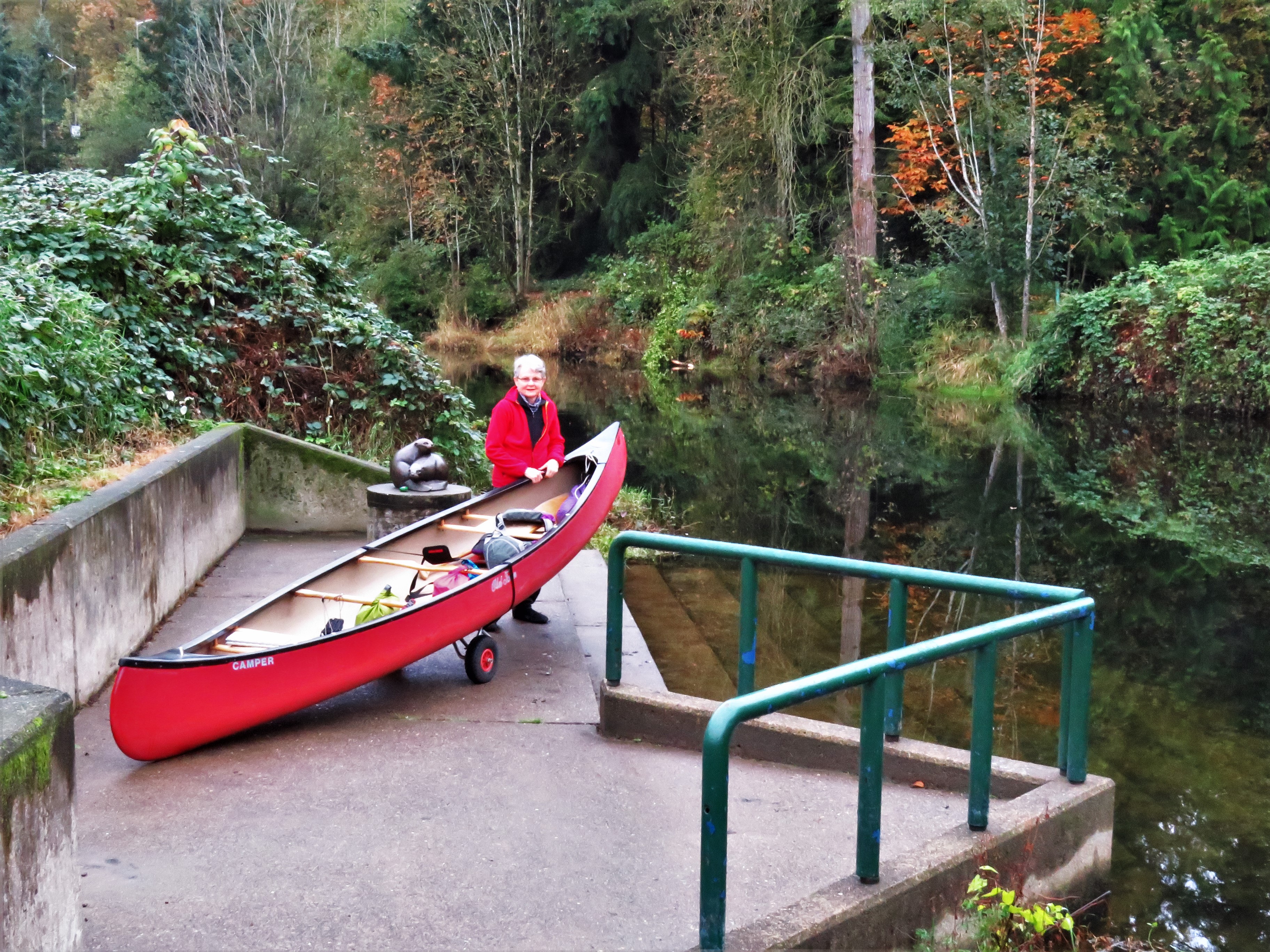
So, what about that canoe we mentioned ages ago? Lucky for us, our condo has kayak, canoe and SUP storage and we have a launch spot only 200 yards/meters away, at a small beach reached by a public access path squeezed between two businesses. Craigslist once again helped us locate a useful item, a set of wheels that quickly strap onto the canoe and allow us to wheel it with minimal effort, even when it's fully loaded with gear. Here is Louise with the canoe 2 hours before low tide, with our condo behind her, and then at the end of that day's trip when we truly were at low tide and the canoe is up on its wheels. The third photo is from the elevator lobby of our condo looking down at our launch spot at high tide. There is still a sliver of beach out of sight to the left, but the spot next to the nearly-disappeared pilings where our canoe had been is now under 12 feet (3.7 m) of Puget Sound saltwater. One learns quickly to pay attention to tide tables around here.
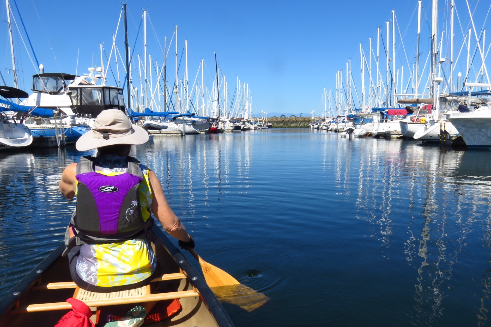
What could we do from here? Well, going back to that photo looking down at the Shilshole Marina, we could paddle from the launch site just behind our condo to West Point, the peninsula sticking out into the Sound, about a mile each way, or take a right turn past our condo and paddle around the marina itself. This was particularly good for days when there was a bit of wind, as the marina sits behind a breakwater and paddling up and down the rows of boats is entertaining, not only to admire the wide variety of watercraft but also to chuckle at some of the creative boat names. Half-way down the breakwater is a sea serpent and a Viking warrior poised to deal with it, a nod to the strong Norwegian heritage of Ballard. Floating past our condo we could see the painters doing the once-per-decade repainting of our buildings, going from the now out of fashion earth tones it's had to a new regime of shades of grey. The last photo shows the painters up close when they reached our floor. Not a job for acrophobics.
Paddling around, we've had harbor seals poke their noses up and look us over, wondering what sort of sea animal we are. But they don't stay long, and attempts to photograph them usually leave us with pictures of ripples of water originating from where a seal once was. Our other local marine mammal, at least close to shore (orcas stay out in deep water and rarely come into this part of Puget Sound) is the sea lion. We have yet to see one from our canoe, and are not anxious to do so, at least close up -- males often weigh in at 800 pounds -- but we do see them occasionally from our condo. Here are two sightings, the one to the left showing three of them having a lazy afternoon float 100 yards/meters from us, with only their flippers and snouts above water, the other of one of the big boys resting more securely on the navigational buoy 150 yards/meters off our starboard bow, so to speak. His pal (or mate?) seems to want a chance too, but at his size, there's only room for one, and that only barely.
If one takes a left turn from that launch spot, the Ballard Locks are just under a mile away. Along the way we passed a boat lifted well up to be sure it won't float away when the tide rises. Not quite sure how they get the boat in the water when it's low tide. In the second photo we're waiting for our turn to enter the small lock. The large lock chamber is at the extreme left. We've seen it hold 100 boats on a busy summer day, but it's mainly seeing only commercial boats during the pandemic. In a kayak or canoe you must use the small lock, the entrance to which is just above Louise's paddle. The dam on the right holds back Lake Union and Lake Washington (which were connected 100 years ago). The third shot is waiting for the final ok to enter, floating next to the barnacle-encrusted wall just outside the gates.
Once in the locks, Louise has thrown our line around the floating wall to our left, which will rise with the water. Next, the gates close, and in the third shot a few minutes later we've risen about 18 feet with water that is gravity-fed from above the dam. All that's left is to wait until the other boats have exited before paddling out ourselves.
What next? Well, the map below shows where we've done a lot of our canoeing this year. This is the Ship Canal, created a little over 100 years ago when a ridge was cut through and Lake Washington on the right was connected with Lake Union, shown as "3." "2" is the Locks and "1" our condo. The three spots marked "L" are where we've launched our canoe all but the one time we came through the Locks. For scale, from our most common launch spot, the L nearest home, it's 5 miles to the L on the right. Just left of that is the fairly obvious cutting point, called in fact the Montlake Cut. The middle L however has special importance -- it has a porta-potty. That has actually been a serious challenge this year, since toilet facilities are pretty widely spaced here and elsewhere we've gone canoeing, even more so as waterside parks and businesses have largely closed altogether or closed their restrooms.
Our canoe weighs 58 lbs (26 kg). Not bad, Jeff once owned a Grumann aluminum boat that was 85 lbs. But it's still a lot of weight. To take it down from the car rack we slide it off the rack and rest one end on the ground, then the two of us hold it near the end in the air, rotate to the side of the car, and gently lower it. Raising it is just the reverse, again using the ground to hold part of the weight as we raise one end. By the way, this is one of Seattle's many street-end boat launches, where trailered motorboats can be rolled right into the water. We've used them often. Outside Seattle, almost every lake and river we've canoed has similar launches built and maintained by the Washington State Dept. of Fish & Wildlife. The latter require a $30/yr permit, a small price to pay for the boating it opens up for us.
What's to see on the Ship Canal and Lake Union? Lots. From the Locks to Lake Union it's mainly industrial. The first photo below shows the drydock for the Foss tugboat company. Nearby there are always a few dozen tugs of all sizes, some even smaller than the small one here. There are also quite a few huge ones, since a lot of goods reach Alaska on barges that start out here in Seattle, pulled by these Big Boys.
There are also lots of compact marinas stuffed full of cabin cruisers. Though no one has precise statistics, Seattle is widely thought to have the highest per capita boat ownership of any large city in America. Having paddled past many such collections we never knew existed since they're mostly invisible from the land side, we're strong believers in the theory. Want more proof? Here's a 4-story boat parking garage with room for a few hundred. Want to actually put it in the water? They'll have it there in minutes with their forklift on steroids!
Between #2 and the leftmost L on the map above you can see a large square seemingly cut out of the south side of the Ship Canal. This is Fisherman's Terminal, where almost every commercial boat that fishes off the coast of Alaska comes during down times when fishing is poor or the season is closed. It's also the home for a small-ship cruise company that calls itself the Uncruise Line. Unfortunately, thanks to the pandemic their large fleet has been tied up here all year. The second photo shows four of their boats, with more around the corner of the boat basin. Let's hope 2021 is kinder to them.
Though some are scattered almost everywhere along the Ship Canal, houseboats begin to predominate in Lake Union. Here are a few with the skyscrapers of downtown not far away. Many are bedecked with flowers and foliage in pots along the decks, but the owners of the houseboat in the fourth photo have gone so far overboard, so to speak, that you can only see a few small fragments of their home through the leaves.
Seattle is widely known for its houseboats, with good reason. They are quirky and quaint. They have been here a long, long time, as the photo below, taken about 100 years ago, attests. But they obtained enduring fame when Tom Hanks lived on one in the movie Sleepless in Seattle. No tour of Lake Union would be complete without a photo of what is unquestionably now the most famous houseboat in the world.
Before you get a realtor on the line to find your own houseboat, consider this -- we once went to an open house on one and discovered that they move constantly, continually, relentlessly. Walk across a room? The whole room will rock. Something larger than a rowboat goes by, even a few blocks' distance away? The upstairs will be rocking and rolling. What to do? Here's a motionless home with views of a dozen houseboats and parking for your speedboat in the watery garage downstairs. Price? You don't want to ask.
Just east of the Montlake Cut on the Ship Canal, the Washington Park Arboretum comes down to the water. We made the mistake of going on a weekend and it was a bit crowded. In canoeing it's usually hard to get within 6' of others, but we had to do so here, unfortunately. And did we mention, it's a bit overgrown with water lilies by mid-summer? Nature provided other enjoyment, such as this lone turtle sunning himself, 2 dozen of his buddies having a sort of turtle group hug nearby, and long-abandoned pilings now providing nourishment for new growth.
But we didn't just boat locally. Indeed, by the end of the year we had put the boat into 22 lakes, 1 freshwater river and three tidal ones. The most exciting trip of the year was on one of the latter, the Snohomish, which we did with friends Steve and Janet in their kayaks. It's a big river that originates in the Cascades 60+ miles away, but is particularly wide near its mouth on Puget Sound. We picked a day with a fairly high high tide that would occur at an appropriate lunch hour We launched 3 miles from the mouth and headed to a park 5 miles upstream. Even though it was less than 2 hours until high tide, the upstream current was a little over 2 mph (almost 1 m per second) since Puget Sound was going up so fast back down at the mouth. As we got further upstream plus closer to when the tide would turn at high tide, the river's speed went down until it was probably only 1/4 mph, but still upstream.
Piers and pilings, relics unused since the days when logs were floated down the river to sawmills nearby, were now coming alive with new life, even new trees, growing out of them. The river is full in late summer and fall with salmon headed upstream to spawn, and we heard them splash around us from time to time. Ospreys and bald eagles were ready to make a closer acquaintance with the fish.
We pulled our boats up and had lunch at the park. We took our time, and a little over an hour later relaunched for the float back down the river. Sure enough, the river was flowing slowly downstream, and sure enough the speed increased back to 2+ mph when we reached the spot where our cars were. It was tricky stopping and pulling up the boat with that current, but that was not the most exciting part of our return voyage. It was 30 minutes earlier, when we spotted a group of 3 seals hauled out on the left bank. The larger ones (mom & dad?) were in serious relaxation mode, while the smaller one (the kid?) seemed to be practicing a yoga pose known as the locust. That's one mighty big locust.
One other tidewater photo is worth sharing, taken when we were paddling the Duwamish River in Seattle. The coho (aka 'silver') salmon were jumping so frequently and so close to us, a few times within 2 canoe lengths of us, that we started to wonder how calm we were capable of remaining if one of these big fish flopped into our boat. Spawning coho run 7 to 11 pounds, but can be up to 3 times that, and when out of water make a toddler tantrum seem like a mild matter. It never did come to that, but we did get to see one out of water on the end of the fishing line of one lucky boater we paddled past.
The one freshwater river was the Sammamish, and the trip was so great we did it twice this year. The put-in was easy and the river current helped us along at about 1 mph. We had locked up Jeff's bike at a park at the take-out spot 12 miles from the put-in, at which point he switched to bike shoes, made absolutely sure he had the car keys, and biked 11 miles back to the car on the Sammamish River Trail that parallels the river but takes a few short cuts at bends in the river. Then bike on roof, drive back to Louise, add canoe to roof, drive home, collapse. Or something like that.
Then there were the lakes. Don't worry, we're not going to go through all 22. They ranged from 100 miles north to 100 miles south of Seattle, and we used a few more Airbnb stays to "bag" a few lakes here and there, particularly at the more distant points, while also keeping Covid-19 as distant as possible. The main criterion for a lake was that it be big enough to make it worth taking down the canoe, which for us was a shoreline of at least 5 miles, though we fudged on a couple. Here are a few photographic highlights:
First, the mountain views. Usually one only looks at the lake and its shoreline, be it nature or homes, but the Pacific Northwest has a lot of very big mountains, and they often pop into view. Our first one is Mt. Pilchuk, just over a mile high, seen from Lake Roesiger, followed by a view of 2-mile-high Mt. Baker from Big Lake. At 14,000' plus, Mt. Rainier gets into lots of views -- here's one from Long Lake to its west, then from Lake Sawyer to its north.
All of these lakes, uninhabited 150 years ago but for the occasional camp made by Native Americans, are largely fringed today by homes that range from weekend shacks to gorgeous year-round residences, with the trend moving toward the latter. Most have tamed the shore, but we found a few where evidence of the enormous cedars and firs that once came to the water's edge has been left in place.
We now interrupt this presentation for the Big Smoke Disaster of 2020. In the second week of September, large fires in Oregon and Washington spewed enormous clouds of smoke, i.e. a dense atmosphere of unhealthy fine particulates just waiting to ravage people's lungs. The winds conspired to bring these all over the Pacific Northwest, and we all became educated about the AQI, the Air Quality Index. In a word, the quality was rotten. For seven days we stayed indoors, venturing out only twice for supermarket runs planned like military operations to get in and get out, quickly. How bad was it? Here are three photos taken from our condo, from bad to worse to better, the latter about day 9.
Needless to say the entire region had a serious case of cabin fever before the smoke cleared. Some smoke came back very modestly a few days later, but mostly in the upper atmosphere where it made things a little gloomy but didn't make Seattle smell like a fireplace and wasn't as dangerous to our health. Thinking we were in the clear (so to speak), we went to Baker Lake, 20 miles from Canada. It's an enormous lake surrounded by a National Forest, and we saw hardly a
soul. Since it's fed by glaciers, the water had that ethereal milky white blue of glacial rivers and lakes. But the normally spectacular views from our canoe of Mt. Baker just ten miles away and 10,000' above us were a little disappointing, though so much better than they must have been just a few days earlier.
A strange thing happened as we arrived. So did a taxi. Not a taxi taxi. A fish taxi. Decades ago two dams cut the native sockeye salmon off from access to the lake. A few remained as kokanee, i.e. landlocked salmon, but a major fishery was lost. Then in more recent years the Dept. of Fish & Wildlife, pushed by Native American groups, environmentalists and fishermen, started to do something about it. For the past ten years they have trapped 12,000 to 28,000 sockeye per year and sent about half to hatcheries and half by fish taxi ten miles uphill from the darned dam to Baker Lake. And yes, they collect the smolt in the spring before they go over the dam, and bring them downhill safely. By taxi.
All of which is a good segue to a Redtandem Blog first: our first video link. Hope it works. We didn't just canoe the rest of the year, we did continue hiking and biking. On a hike in early November to nearby Carkeek Park we kept a close eye on Pipers Creek, remembering from other visits that it is a salmon stream, even though it and it's one tributary add up to at most a mile of steam that a salmon might be able to navigate. We had never seen salmon in it. But November is the best month to see them. And did we ever!
The video is 64 seconds long and starts with a lot of thrashing about. We're not experts, but we can tell you it's one of two things, and perhaps both. A female salmon does this to create a redd, the term for a place where she decides to build a nest for her eggs. Male salmon need to fertilize the eggs soon after, and sometimes they compete to be The One and Only. Near the end of the clip, you can see one salmon scoot away at high speed. We suspect he's an unsuccessful aspirant. Or not. Perhaps this is all an anthropomorphic sex fantasy. Anyway, here's the link:
Winter has been a new challenge. It's been hard enough all year doing walks and especially bike rides with no opportunity to pause at a café for a coffee or a lunch. Turn the thermostat down into the 40's and it's harder yet. There have also been closed rest rooms, though Seattle Parks have been pretty good about keeping most open, or setting up porta-potties next to brick and mortar ones they chose to close. But somehow, we've managed. We'll close out today's (actually, this year's) blog with one more bike ride, one more walk and one more canoe trip, all done in December. It's possible, folks.
The bike trip was to Rattlesnake Lake, a place we biked to 26 years ago up a steep and winding paved road. We'd not been back until this year, when we rode up there in September (seen to the right) with trusty outdoor companions Steve and Janet. Had a quick picnic up at the lake, then down again. It was already getting nippy then. In December we headed up, just us two on our tandem. It was around 40° F (4° C) as we left the town of North Bend and headed up the route we used 3 months earlier, the Snoqualmie Valley Trail. It did not exist 26 years ago, when the trail was then merely abandoned railroad tracks of the bankrupt train line known as the Milwaukee Road. Now it is is a wonderful packed limestone trail that climbs gently for 3 miles, then at a steady 2% grade for another 4½ miles. That is a very manageable gradient, one we did largely in 5th gear on our 14-speed tandem.
It was even nippier. A dusting of snow was on even some of the short mountains nearby, and frost on the ground next to the trail. It was surprisingly busy with bikes and walkers, almost 2 dozen of the former and half a dozen of the latter on our hour-long ride to the lake. The deciduous trees were bereft of leaves, but their intricate skeletons were clad in green moss, for we were now in the foothills of the Cascades where the rainfall increases with every foot of altitude gained.
Rattlesnake Lake was once tiny. A small town of railroad workers grew up beside it when the Milwaukee Road built a rail yard here, and a junction where trains from Chicago could head west to Seattle or northwest to Everett WA on the route that was now our trail. But then dam workers arrived at this town, Moncton, and constructed a large dam nearby so that Seattle would have enough drinking water. That raised the water table. And that raised the lake. And trouble. A diagram on a sign at the lake and a photo of one of those houses tell the story. The water receded for a short while, long enough to tear down what was left of the town, and only a few foundation stones remain, buried deep under the lake. That's it today in the third photo below. And that picnic lunch? It got eaten, quickly, the two of us clad in additional clothing that we hauled up the hill in our bike panniers just for that purpose. And the restroom was open.
Our last big hike of the year was not far from home, a stroll around a neighborhood called Queen Anne. It's one of the most charming residential parts of Seattle thanks to the many older and well-kept-up homes and to the views that abound, since QA (as it's also called) is one of Seattle's higher hills, topping out at 456 ft. (189 m).
Before setting out Jeff texted friends Kal and Amy, who had been posting photos on FaceBook of a snowy owl that had taken up residence near their home on QA. They gave us two blocks to check out and the wise suggestion to just look for a crowd of people. We did, and by following their collective gaze we quickly had the beautiful bird in the crosshairs of our camera.
Nearby was a Little Library, a local institution that involves boxes like this scattered all over the city. People put books they no longer need on the shelves, and other people pick them up. We've actually found a few children's books that Jeff has read to granddaughter Draelen, and picked up a copy of Churchill & Orwell that he plans to read himself fairly soon.
Next we crossed the hill to its eastern edge and looked down at Lake Union, talking about all the places on the lake we've canoed this year. The park on the peninsula is Gasworks Park, which won a passel of awards in the 1970s when it was created out of an abandoned gasification plant that turned coal to cooking and heating gas. Kids love it for the odd and intricate machinery frozen in place and painted bright colors, terrific for climbing on. In case you're wondering, Tom Hanks's houseboat is roughly behind the last tree on the right, but below a steep bluff there, well out of sight.
Round the hill to the southeast facet and there's a great view of the Space Needle and downtown from Bhy Kracke Park, named after Werner Kracke who picked up the unusual nickname because he loved the expression "by cracky." He also donated the land for the park. There's a conifer just left of center. Behind it and to its right and left is "Amazonia," the part of Seattle where roughly 50,000 employees were working for you-know-which-company until the pandemic scattered most of them to their home offices around the region. You do not want to be a restaurant owner in that deserted part of town just now.
On the way to the next viewpoint one passes a gorgeous older mansion. We've been told it's the home of the Japanese Consul, and the rising sun flag and the chrysanthemum emblem of the Japanese emperor over the main entrance lend credence to that story. A few blocks more and you're at the most famous viewpoint in Seattle, Kerry Park, with yet another stunning view of the Needle and of downtown. About one day in four you can also see Mt. Rainier, but this was not one of them.
But we're not quite done with views. At the southwest corner of QA is another pocket park with a great view to the west, with the Elliott Bay Marina below and the Olympic Mountains on the horizon 50-60 miles away. Turn 45 degrees to the left and you're looking at the "south sound" portion of Puget Sound, with Alki Point in West Seattle behind the state ferry and Vashon Island behind that.
Not all neighborhoods in Seattle have so many viewpoints, but many are fun to walk at any time. With extra clothing and warm soup and coffee in our thermoses, we hope to continue strolling through them and even stopping and picnicking in them as we stay active through this challenging time.
We promised one more canoe trip, and it was on a small lake we had paddled once before and loved for its quiet charm. Beaver Lake is not quite 3 miles around and bordered for 2½ of them by homes, plus a park and a nature preserve. But there are lots and lots of trees all around, adding to the charm, even in the restrained palette of winter. There was still snow from a day or two earlier on north-facing lawns, for we were 500 feet above sea level, and Seattle is a place where in winter it often rains at sea level while it snows on the tops of those 400+ foot high hills.
But Beaver Lake had a surprise for us. It was the afternoon of Christmas Eve. Homeowners on the lake have had a tradition of building docks with an extra dock-like section that floats, attached by ropes or latches to the dock. This floating section often has outdoor furniture and even fire pits clamped onto it, and on one side sports a board on which one can attach an electric motor. We had seen and commented to each other about these on our earlier trip, but none were ambulatory at that time. Today, however, they were on the march, and while we paddled our canoe about the lake, seven of them gathered for an impromptu Christmas party, properly spaced 6 feet apart, in the middle of the lake. What a way to end the pandemic year's adventures, with a little good cheer and hope!
As we write this, about 1% of the U.S. population has gotten its first vaccination shots. As we peer into the future, will we see an end to the Coronavirus pandemic in 2021? And if so, how soon will it get under control? No one knows, but we all have hope.
What will it bring for us? Is there any hope for resurrecting our plans for a trip to the Netherlands? How will this strange year have affected the Dutch? In strange ways?
Or will we be spending another year staying active in our own corner of the world? At least we're now ready with the tools to do so in a fun way.
Thank you for joining us on this tour of the outdoors in Seattle and somewhat beyond, and we hope some of you find inspiration from it to "up your game" as well, but always in a safe and sensible way.


 However on this particular day Jeff has substituted homemade cole slaw and cheese and crackers in place of, as he likes to put it, yet another sandwich. He seems to be enjoying the switch. Lunch is never a rushed affair, as you can see, with both of us well supplied with reading material. Of course good conversation substituted for the reading when our friends joined us the following week. In case you're wondering, this charming spot is in West Seattle, and we're looking north with the Space Needle just left of the low-hanging branch and the dark Columbia Tower to the right of Jeff. Those orange things are therma-rest seat cushions that deflate for compact storage in our bike pannier. They and our colorful plastic place mats brighten up our repast.


 Jeff also got into Zooming in September when granddaughter Drae started First Grade and her brother Cedro Fifth. Most weekday afternoons Jeff got on Zoom to work with Draelen on learning to read, and on reading wonderful kid books like Holes and Auggie & Me with her brother. It was only 20-30 minutes with each, but it has developed a closeness that had been harder to achieve when their home was a thousand miles away in LA, rather than a few clicks away on the internet.