It's good to be back on the bike, but it was a challenging first week. We started out easily enough with the ferry trip from Wellington on the North Island to Picton at the top of the South Island. The bike assembly area was, uh, well-marked, and the bike went onto the bottom deck,

which at times is filled with railroad freight cars. The route is very scenic, out past Wellington Head,

which we've previously sailed past coming in and out of the harbor on the Volendam, and across Cook's Strait to Queen Charlotte Sound. That is a remote stretch of coastline,


where we saw only an occasional house at the waterline, and not much else that nature didn't put there. At last Picton hove into sight, along with a sister ferry boat headed north, leaving Picton.

That day was short, about 15 km including a short ride around the Picton area, and the next was also an easy 40 km, fairly flat as it took us into the heart of NZ's wine country. For almost 50 km, much of that day and the first part of the next, we had vineyards constantly in sight, usually right next to us and sometimes on both sides of the road.

Day three was a big challenge. The road went straight up the Wairau Valley along the Wairau River 
and then up a side stream that brought us to a col at 727 m, about 2300', followed by a short descent to Lake Rotoroa in Nelson Lakes National Park. In those 93 km there was only one town, at 25 km, where we refilled the water bottles. Unfortunately, we did not have enough water bottles to fill for those next hot 70 km, and we were rationing the precious fluid for the last hour or two. With some headwind and constant climbing, our average speed sounds ok -- 17 -- until you convert that from kph to mph, where it comes out a wimpy 11. We both started fantasizing about a pickup truck loading us and our bike aboard for the steep last part of the climb, but the highway, a fairly major highway by NZ standards, was averaging only 3 or 4 cars an hour in our direction, and about the same the other. And none of them was a pickup.

and then up a side stream that brought us to a col at 727 m, about 2300', followed by a short descent to Lake Rotoroa in Nelson Lakes National Park. In those 93 km there was only one town, at 25 km, where we refilled the water bottles. Unfortunately, we did not have enough water bottles to fill for those next hot 70 km, and we were rationing the precious fluid for the last hour or two. With some headwind and constant climbing, our average speed sounds ok -- 17 -- until you convert that from kph to mph, where it comes out a wimpy 11. We both started fantasizing about a pickup truck loading us and our bike aboard for the steep last part of the climb, but the highway, a fairly major highway by NZ standards, was averaging only 3 or 4 cars an hour in our direction, and about the same the other. And none of them was a pickup.
So on we toiled, about 5 1/2 hours of actual biking (well, half and hour of that was pushing the bike up two sections where even 6 or 7% grades seemed too much for us), and a lot more time on breaks to catch our breath and stretch. But we made it, and had three nights to recover in this beautiful location. 

Walking actually proved therapeutic for our aching legs, and as always in NZ there were great trails along the lake for us to explore.


Around 8 pm the sun got low in the west and made for interesting shadows on the hills and a nice backlighting for this cormorant.


Walking actually proved therapeutic for our aching legs, and as always in NZ there were great trails along the lake for us to explore.


Around 8 pm the sun got low in the west and made for interesting shadows on the hills and a nice backlighting for this cormorant.

The next day was an easy 60 km following the Buller River southwestward toward the Tasman Sea.

We broke up the pedalling with a twenty-minute hike across an abandoned railroad bridge and through this tunnel, looping back over the same hill.

Our destination was the BBH in Murchison, run by a lovely English couple who emigrated to NZ a year ago to reinvent themselves after a lifetime of living in the same small community in the UK. BBH is a network of hostels, but they're better than the youth hostels we've tried in the US and Canada. They are individually owned, usually by couples, and they are all over NZ, in almost every town we're going to stay in on our cycling trip.

They always have community cooking facilities, and we've always been able to get a private room with either a queen sized bed or twin beds. Indeed, the directory makes them easy to assess beforehand and to find when you bike into a new town. They've ranged from good to great, and at an average of just over NZ$60 (less than $35 US at the current exchange rate) per night, they are doing wonders for our budget!
Our next day was another long one, the remaining 98 km down the Buller to Westport, again to a BBH, or "backpacker" as they're also called. As we checked in, the owner commented on our tandem, said they've hardly ever had any come by, but that tonight we were the second one to arrive! 
And so we spent a good bit of the evening chatting away with Lin and Bernard from Manchester England, also retired from a university job, who are riding around the South Island clockwise, the opposite direction from us. But that allowed us to trade info about what was ahead, and there is a chance our paths will cross a few hundred km from here in the Queenstown area -- we exchanged email addresses and cell phone numbers to stay in touch.
By the way, we did stop at one place between Murchison and Westport that is supposedly the most-photographed piece of road on the South Island. The photography started over a century ago, as the historical picture shows,

and the road is just as narrow today, though with a guard rail at least. We also had our day brightened at many places along the road by this bright orange flower, which we had not seen along North Island roads.
The shoulder came and went, but the traffic was light and it did not seem dangerous at any point.

And so we spent a good bit of the evening chatting away with Lin and Bernard from Manchester England, also retired from a university job, who are riding around the South Island clockwise, the opposite direction from us. But that allowed us to trade info about what was ahead, and there is a chance our paths will cross a few hundred km from here in the Queenstown area -- we exchanged email addresses and cell phone numbers to stay in touch.

By the way, we did stop at one place between Murchison and Westport that is supposedly the most-photographed piece of road on the South Island. The photography started over a century ago, as the historical picture shows,


and the road is just as narrow today, though with a guard rail at least. We also had our day brightened at many places along the road by this bright orange flower, which we had not seen along North Island roads.

The shoulder came and went, but the traffic was light and it did not seem dangerous at any point.
Westport became a major city as a commercial center for gold diggers in the 1860's, then for coal miners as one mineral ran out and the other proved to be easy to get. Easy to dig for and get, but not easy to get out, as it was mainly hundreds of meters up into the Southern Alps. One of the most famous places was Denniston, and we both recently read Denniston Rose, a novel set there that is in all the bookstores as a best-seller. Denniston had a famous way of getting the coal to market, it put it in rail cars that descended the Denniston Incline at a 35-40% grade, the weight of the coal in the descending cars providing the power to bring up the empties and anything else, such as mail, or anyone, such as everyone wanting to get to Denniston, as the Incline was the only way up there for its first 20 years.
The Coaltown Museum in Westport had a Denniston coal car set up at the correct angle -- 
can you imagine sitting in that thing, covered in coal dust and being whizzed up a mountain at what must have felt like close to straight up? Many who did it swore never to do it again, and stuck with that resolve, staying in Denniston for decades. They only left when they were dead, as the ground was so rocky they couldn't be buried in Denniston! By the way, the trip down was actually two trips,
as the cars had to be taken off one set of tracks and relaunched down a second set at the midway point. The museum had this historical photo showing that spot, called Middle Brake. Working there, in the line of fire of any descending coal car that broke a cable or a connecting pin, made it a less than popular job location.

can you imagine sitting in that thing, covered in coal dust and being whizzed up a mountain at what must have felt like close to straight up? Many who did it swore never to do it again, and stuck with that resolve, staying in Denniston for decades. They only left when they were dead, as the ground was so rocky they couldn't be buried in Denniston! By the way, the trip down was actually two trips,

as the cars had to be taken off one set of tracks and relaunched down a second set at the midway point. The museum had this historical photo showing that spot, called Middle Brake. Working there, in the line of fire of any descending coal car that broke a cable or a connecting pin, made it a less than popular job location.
After our long day, we compensated with a short ride out to Cape Foulwind, named by Capt. Cook but the name fit the day we rode there, a stiff headwind that made our 13 km flat ride far from easy. But just down the road from our motel was another grand walk along the cliffs 


to a spot where we could look down at a fur seal colony, the southern-most one in NZ for this particular type of seal. There were once enormous numbers of seals in NZ, but fashion and greed combined in the early 1800s to bring them to near-extinction.


to a spot where we could look down at a fur seal colony, the southern-most one in NZ for this particular type of seal. There were once enormous numbers of seals in NZ, but fashion and greed combined in the early 1800s to bring them to near-extinction.

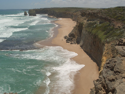
That brings us to today, and the "Pancakes" of the blog title. Since Westport we have been in what Kiwis call "Westland," a narrow band of land wedged between the Southern Alps and the Tasman Sea. Today we rode 60 km, sometimes along wave-swept beaches, more often climbing over hills that brought us as much as 200 m above the water,

almost always hearing the pounding of the surf. At last we descended to Punakaiki, home of the "Pancake Rocks."

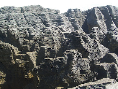
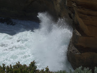
 And sure enough, they are pancake-like! DOC, the Dept. of Conservation, has once again built a wonderful trail through them and to places where the incoming waves shoot up through blowholes, sometimes shooting 50 or 60 feet into the air!
We have our "bike legs" again, more or less, and have a route down the west coast that is fairly well broken into 40-70 km segments. Part-way down the coast we climb a little to the base of two glaciers, or glah-see-urs as Kiwis pronounce them, then return to the sea for a few more days before climbing into the Southern Alps again. We'll "talk" to you next from there!


