After a 36-hour voyage from New Caledonia, just inside the tropics at 22 degrees, we reached Bay of Islands NZ, about 35 degrees from the equator, which is comparable to Cape Hatteras, Memphis TN, or San Luis Obispo.

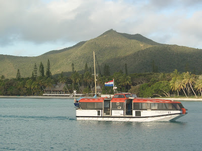
That was the first of four ports we visited prior to Auckland, where we've now been for a week. The ship slipped past a few dozen islands and anchored, and we tendered in to Waitangi, sort of like coming to the US from Europe and landing simultaneously at Plymouth MA and Concord MA and Williamsburg VA, as Waitangi is "the birthplace of New Zealand." The most important single event in NZ history occurred here on February 6, 1840: the signing of a treaty between the majority of Maori tribes and the British, in which the Maori agreed to become subjects of her majesty Queen Victoria in exchange for the protection of the crown and the preservation of their rights.


We had a full day of hikes, however, and will say a bit more about Waitangi and its chequered role in NZ history a week from now, when we pay a return visit by land. On this first visit we took off on two walks, first of course up the nearest hill with a viewpoint, then past a mangrove forest


to a small but scenic waterfall, both accompanied by our cruise friends Neil and Esther. It's early Spring here, and the weather was in the high teens -- Celsius, that is, or mid-60's Fahrenheit.

The trails were easy to find, well-marked, and extremely well-maintained, as all the half-dozen trails we've taken now in our first week and a half have been. We're gonna really like it here!
At each port, we arrived at 8 a.m. and sailed about 5. Leaving Bay of Islands, we had just enough daylight to see the famous "Hole in the Wall" rock from the west, then to look back westward at sunset for another (un-holey, but colorful) view.


Overnight our boat took us to Mt. Manganui in the Bay of Plenty

-- apparently the Maori were generous in providing for the dietary needs of Capt. Cook, who gave it that name. The four of us, including Neil and Esther again, took a walk around the base,

then Jeff took off for the 232 m (about 750') summit,


where he got to look down on a paraglider who was checking out the town. Kiwis are into extreme sports like the Germans are into beer, and are throwing themselves off cliffs, bridges and buildings everywhere we go. We'll say more about this further on!
Down at the base of Mt. M. was the only saltwater natural hot springs resort in the southern hemisphere,

and with exclusivity like that, of course we wanted in. Here's Louise checking out their version of a water jet. Afterwards we walked the stunning beach, and did a little 'catch and release' shell collecting for the close-up shot.

Off we sailed again at 5 and arrived the next day in Napier, on the east side of the North Island. Napier was hit by a 7.9 earthquake in 1931 and downtown was pretty much levelled by the quake and subsequent fires.


It was quickly rebuilt, however, and it was decided to rebuild with reinforced concrete in the latest style, Art Deco. Napier consequently has the largest and most concentrated collection of art deco buildings in the world! It was interesting . . . but Art Deco is a very restrained style, and frankly looks best when it's a counterpoint to other more exuberant styles.

A whole downtown of art deco buildings is like a whole museum of Picasso in his blue period. OK, impressive, but . . . For contrast, we headed to the residential area (and a high lookout point, of course), and discovered this,

our first cherry tree of the Spring season, plus a lot of 19th century Carpenter Gothic Victorian homes that survived because wood buildings as a rule survive quakes better than stone, due to their flexibility.
Our fourth stop was Wellington, the nation's capital and second-largest city, which is about as far south of the equator as NYC is north. We'll be back in December, so decided to focus on just one thing, and that was Te Papa, as the National Museum is known in Maori as well as by Pakeha (the Maori word for non-Maori, a word much used in NZ by Pakeha as well as by Maori).

There was lots to see, but we'll limit the pictures to just these two. The first is of Louise with a moa, a now extinct bird. It had only one natural predator, the eagle whose claws you see about to attack it, until the Maori arrived. Not being members of the Green Party, they did what any normal group would do, they hunted it to extinction. And then starved, literally, as moa had become a major source of their protein.

Any lessons here for countries that view the ocean as having unlimited fish? The second photo is of NZ from space (this part is the North Island looking north from the Wellington area), and we spent many excited minutes studying where we expect to cycle in the coming months.
At last we reached Auckland and said goodbye until March 16 to the Volendam.


We'll reboard it then for a cruise to Japan via many more exciting places, stay tuned for that next spring. It has been a wonderful cruise, well beyond our expectations. One of the little things that made it fun were the daily towel animals that our cabin attendant Sukarji made from ordinary handtowels. We also got much more out of our visit to the South Seas islands we visited thanks to the lecturers, particularly Professor Cluney MacPherson, a Sociologist whose specialty is Economic Development.

It's so rewarding when you have a good professor or a good book to tune your eyes to the correct frequency where you begin to see things that otherwise would have been fuzzy.
Well, it's been a busy week here, so let's just talk about three things: extreme sports, a surprise invite for a drive out of town, and a hike up a fairly new volcanic island.
You'd think the middle of NZ's biggest city would not be a place for crazy stuff like bungy jumping -- remember, NZ is the birthplace of bungying -- but you would be wrong.

Walking down a major street, we saw these folks getting onto what looked like a stainless steel sofa (click on the photo to enlarge it to see what a flimsy little escape vehicle they're on! -- hit the back button to return here). Then those cords tightened up faster than you could say "Holy S---!" and these guys went from zero to 120 (and that's mph, not kph!) in 2 seconds flat, hurtling waaaaay

past the tops of those tall towers and then bouncing up and down, bungy style, for a minute or two before being let back to earth. OK, that's wild! Then we turned the corner and came to the Sky Tower, the tallest man-made structure south of the equator at 333 m (a tad over 1000 feet). It's a bird! It's a plane!

No, it's another crazy Kiwi in a 500-foot freefall off the Sky Tower! Yup, you go up to the 192 m level, get a tether attached, then they lower you below the platform and leave you dangling for a few seconds, then let you rip. You free-fall until you're only a few stories away from going splaaaat when the guy wires to the sides slow you down for a remarkably smooth landing. Oh, those fun-loving Kiwis!
In our 8 days in Auckland, we managed to find quieter fun in three cultural events: a chamber orchestra concert, a symphony concert, and a performance of Lloyd Webber's Phantom of the Opera. At intermission for the first of these, Louise asked a woman about our age with a haircut she admired if she could recommend a hairdresser, as it's been 5 weeks.

Before intermission was over Gae had invited us for a drive in the country two days later. We stopped at a beach near her "bach," Kiwi for a weekend place in the country, then drove over to Tawharanui Regional Park.


Oh, what a beautiful country this is! We took a 5-mile hike over a few stiles, past a few of NZ's 34 million sheep,

and down this 20% slope that's advertised to be a mountain bike route. We also got to see how hilly, twisty, narrow and sometimes shoulderless the roads are in the "Northland," the area north from Auckland.

Gae might have saved our lives, as we came back convinced that this part of NZ is just not worth biking -- way too dangerous. We leave tomorrow in a rental car for a week's jaunt, figuring we'll get plenty of exercise on the walking trails (or "tracks" as Kiwis call them), and will start our biking a few days later with a ferry ride out of Auckland to a much quieter part of NZ.

Another adventure in Auckland was taking the ferry 30 minutes to Rangitoto Island, which did not exist until it popped out of the sea about 600 years ago, the most recent of the 52 volcanoes that make up Auckland and its immediate surroundings. Here's a shot of Rangitoto from Mt. Evans, another

one of those volcanoes that's now a park near downtown with killer views. As a fairly new place, vegetation is still in the process of getting a toe-hold on Rangitoto, yet there were some parts of the island with tall trees and reasonably dense vegetation.


Near the top we explored these lava caves, created when molten lava created its own tunnel, then left it empty when the flow stopped. One last push and we were to the 700' summit for this view of downtown Auckland.

Sorry, no pictures yet of Louise's new haircut, but it's been called "trendy" and "youthful-looking," so it might make it hard for us to convince places to give us a senior discount. We'll write next about our adventures in the Northland.


