

We started this year's trip by biking down the Main River and several of its tributaries until we hit the Rhine. Today we will take you a short way along the Rhine to the Lahn and head upstream. At the top of the valley we'll cross to the Eder River and head downstream. On the map, the Rhine is in pale green, the Lahn in dark green and the Eder in blue.
When people get excited about the scenery along the Rhine, they almost always are focusing on this short stretch of about 70 km between Bingen and Koblenz. It is chock-a-block full of steep hillsides either deeply forested or coated with vineyards, and amply adorned with all sizes and shapes of castles. The river itself is alive with boat traffic, much of it commercial but well-leavened with tour boats, both long-distance ones like the Viking boat in the first photo below, or day trip packets like the steamer in the second photo. We've thrown in a few other photos of this gorgeous place for good measure.


Shortly before entering this magical world we biked past Schloss Biebrich, the ancestral home of the dukes of Nassau and perhaps the most elegant palace on the entire river.


We learned a trick four years earlier, when we biked this same section of the Rhine. There is a LOT of traffic along the Rhine. Not only all those boats, but also large numbers of trains, trucks and cars. There are tracks on both sides of the river, with 2-4 trains per hour on the east bank and easily twice that on the busier west side of the river. So to get a good night's rest, we found a place that was 350 meters up a side valley from the town of Bacharach. Yeah, it was a steep enough climb that we had to push the bike up that hill on the way to it and keep the brakes on all the way back down the next morning, but we had a totally quiet evening, and got some nice scenery on the way to our lodgings and also looking out the window in the morning.


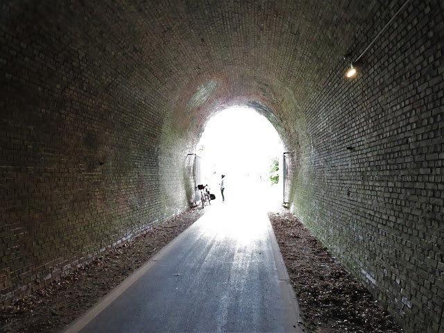
The valley, as we noted, is quite narrow and steep in places, and the trains go through many tunnels. The tunnel entrances are invariably decorated with castle-like portals. As tourists from America started pouring into this area in the '50s and '60s, many speculated that the Germans had done this so that American bombers wouldn't attack them, thinking they were castles. Nice theory, but no, that's not the reason. The tunnel entrances have looked like this since they were built, both to fit in with their castellated neighbors and to enhance the tourist charm for 19th century train travelers.

This was actually our third time coming along this stretch of the Rhine. The first one was in 2015 when we were biking from the Main River valley down the Rhine to Koblenz to then head west up the Moselle, and the second visit in 2017 was by boat and train when Jeff was recuperating from a badly sprained ankle. As the ankle got better we hobbled one day from a boat that runs up and down the river to a chair lift that brought us to a spectacular view of the Rhine. As we passed it this time from the opposite shore, we put the camera on maximum telephoto and watched a few of this year's tourists both walking and riding the chair lift up to see that view for themselves.
At last we reached Lahnstein at the mouth of the Lahn River. Castle Lahneck still towers above the river here, but one has to use some imagination and rub out the 20th century buildings in the town below to capture its charm.

We turned up the Lahn a dozen km to Bad Ems, following a narrower than usual trail past numerous boat locks. The only boats we saw moving, however, were countless canoes and kayaks, always heading downstream. This continued on subsequent days for the entire lower 100 km of the river that are fitted with dams and locks. We'll say more about those locks in a bit.

Bad Ems is a charming spa town with an enormous historical spa complex and one or two more modern ones nearby. A telegram sent from the spa by Kaiser Wilhelm to Chancellor Otto von Bismark in 1870 became known as the "Ems Telegram," and when it was leaked to the press it led France to declare war on Prussia, a war the French quickly lost, with severe consequences for all of Europe. As for the mineral waters here, there were two very odd things we passed by. One was a tall glass beaker with a tap you could open to taste the slightly brown water. We were dissuaded to do so when Jeff noted that the temperature was 46 C (115 degrees F). Nearby was a fountain spouting water. The sign next to this one stated that it was usually about 55 C, as if the steam coming from it wasn't warning enough. Quite a place!


The next day posed a challenge. In the middle of the day's ride was a hill that jutted up sharply 200 m, over 600 feet. Not only that, but there was no bike trail, only a shoulderless and moderately busy road. Our bike book had the perfect solution: bypass it by taking the train from the stop before the hill to the first stop after it. Jeff checked out the logistics in the Spring and saw that there were trains all day long, so no problem, right? Wrong! A few weeks earlier they suspended all trains for the summer and replaced them with buses while they tie in a new tunnel. Oops, those buses aren't equipped to take any bikes, let along a long tandem..
At least we discovered this before heading further up the Lahn. After breakfast we instead headed back down the river to Lahnstein and caught a train to Frankfurt and then a second train on to the town we wanted to reach, Limburg. So we moved 50 km up the Lahn by taking the train 180 km, two thirds of that right along parts of the Rhine and Main Rivers we had just spent a few days biking along. Well, all part of the adventure, plus we got to see the Rhine River yet again, this time from the east shore.


Limburg was a charming town, full of splendid half-timbered buildings, called Fachwerk in German, and with lively crowds of shoppers and restaurant patrons.


One building illustrated the challenge of keeping these structures looking so good. One side of the building had been renovated, and the adjacent side is still waiting.


This is quite an old city. The next photo was taken from the stone bridge that was put up exactly 700 years ago, when the cathedral you see up on the hill was already 40 years old.

Our ride the next day took us past this attractive parish church dedicated to Saint Lubentius, a saint neither of us has ever heard of, and on to yet another ancient stone bridge, this one dating to 1448. Looking down on the bridge is Schloss Runkel, after which the town is named. It was there during the reign of the emperor Barbarossa, in the mid-1100s. Quietly, off to the side, was yet another one of those boat locks.


In Weilburg, our destination that day, we finally got up close and personal with the boat locks, for here was an extraordinary one. To avoid a large bend in the river, a tunnel was bored under the city with a pair of locks at the downstream end to raise or lower boats. A couple were coming through with their canoe, the woman handling the boat, the man working the do-it-yourself locks.

At the time we arrived they had already come through the tunnel under the city, opened the upper gates, and entered the upper lock chamber. Next, the guy had to crank open doors within the lock gates to let the water out. Next he leaned hard into the gate arm, and his partner finally was able to paddle out directly into the lower lock chamber. Note from the water mark on the wall that she's come down 2 or 3 meters.


Of course this all had to be done now a second time, so Jeff jumped in and helped crank open the windows in the lower gate to help get them on their way.


Our hotel was close by, and that evening we walked up to Schloss Weilburg, which is almost directly above that amazing river tunnel. The Schloss was closed for the day but the former ducal gardens are open now as a public park. Unusual as well as scenic.


We captured this charming view of the university city of Marburg while biking into town, but unfortunately never got to do any further sightseeing despite two nights there. The next day it rained much of the day, lightly but enough to discourage exploration, and in any event we had two important duties to attend to: much needed haircuts, and much desired work on this blog. Yes, folks, this is where the last episode of the blog was largely created, sitting by the window looking out at the rain and listening to music from our iPad as the blog took form.

The next day promised rain again, but this time just in the afternoon, but in the form of thunderstorms. We got up earlier than usual, tarried much less over breakfast than we normally do, and were out the door at 9 (sorry, all you working folks out there who have already commuted to work to be there at 9 or earlier, but one's timing really changes when you become retired folks like us). In any event, we were 38 km down the road and up at our hotel before the church bells chimed 12. At 2 o'clock, pretty much when promised, the skies opened up with hail and then thunder and lightning on a Wagnerian scale. Dinner was just down the hall from our room, at the other end of the hotel, and the electricity never went out, so we got to enjoy a light and sound show courtesy of nature. The next morning there was still a little mist in the air as we looked out at Schloss Biedenkopf (the castle tower on the adjacent hill) and at the city of the same name down below it.


As you can see from those last pictures, we are now in an area of something between large hills and low mountains. We have climbed from an elevation of about 65 m at Lahnstein to almost 300 m here, without any real sense of having gone uphill. As we made plans the night before, during that thunderstorm, the forecast was for showers in the afternoon. We checked again when we woke up, and the showers were slightly later, but still in the forecast. So we made a plan to go 20 km to a nice hotel that would at least get us up to 400 m elevation and closer to a destination on the other side of the high point. But near the end of breakfast one last check of the computer showed the forecast moving the rain to 5 pm. OK, let's go for the full climb to the top, only 12 km further but 200 m higher. Good call!
All of our other trips in Germany have largely been ridden in valley floors of larger, more level rivers. This was our first time climbing in a hilly region. The landscape was beautiful. At a little over 400 m we went past a stunning Relais & Chaateaux hotel that appeared to be an old hunting lodge, and poked our heads inside for a view. We had thought about staying here at one point, but the room prices of 2 to 3 times our daily average quickly changed our minds. One certainly does get charm at that price, though.


That was a real wood fire in the fireplace, for it was about 61 F / 16 C and we had almost every piece of warm clothing on. A kilometer past the lodge the asphalt road turned into an unpaved one. OK, only 3 km more. We were still pedaling, on a grade of about 4%, when we stopped to take two photos of the Lahn River, which one could now step over.


With just over a kilometer to go, the "fun" really started. The road suddenly went to a gradient of 8-10%, and the road surface went from tolerable to unrideable, even if we could manage a slope like that. There was a time when we might have, but that train left the station a few years ago. Louise took over the camera for a few "action" shots. Very slow motion action, actually.


At an elevation of 620 m, just over 2000 feet, we had reached the Lahnquelle, the source of the 250 km-long river we have been following for 6 1/2 days. It's a tiny pond, and right next to it is the Forsthaus Lahnquelle, the Forest Hotel Lahnquelle. In fact one of those windows is our room for the night. It was one of the quietest, most magical nights we've had yet, knowing that it will be "all downhill from here." Well, not quite, but there will be no more elevations like this in the kilometers to come. And those rain showers never did show up.

It was now time to descend to the Eder River, which we will follow for about 160 of its 175 km, or just over 100 miles. But first we had to ride 6 km up and down gentle grades as we followed the crest of the hills that spawn 4 named rivers. There were no stunning viewpoints as the ridge is gently rounded and heavily forested. At last we reached a brook that flows into the Eder River and followed it downhill for 9 km. We reached the Eder in the town of Erndtebrueck as a Schutzfest (Shooting Festival) was starting. Of course, it starts with some beer drinking and a concert provided by the Musikverein, or Music Club, dressed in their nice grey uniforms, with an audience composed of Schutzverein (Shooting Club) members in forest green and other folks in uniforms of other colors, along with "just folks" like us. A parade was scheduled to start in 15 minutes, but we did not stay as we still had 30 km to ride.

The first 15 km turned out to be hard. It started out with decent pavement, but that soon morphed to rougher pavement and soon after to a dirt road.

It also went from open meadows to forest. That section, compared to other unpaved roads we've ridden in the past few weeks, was rougher and more up and down, as it is used, duh, for forestry and not agriculture. When it brought us to a paved section we heaved a sigh of relief. When the official route headed back to the forest and the map showed more up and down sections, we stayed on the road. It was slightly downhill with a slight tailwind, and we mostly rode at 24-30 kph / 15-18 mph). It's legal to do so in Germany, and drivers are used to slowing down and passing cyclists, tractors and the like. There was little traffic, and the few drivers who did come along were extremely polite and passed us very safely.
We spent that night sleeping in class. Well, perhaps. The hotel was Die Alte Schule, the Old Schoolhouse, but it consisted of three buildings as it has proved to be a very successful hotel, and we rather doubt our third-floor room was ever a schoolroom.
The next morning was once again quite cool, 12 C / 54 F, even though we had descended to 400 m. Louise was clad in her fullest panoply of cold-weather protection, including earmuffs under that hood and three more layers of clothing underneath the wind jacket. That's our hotel behind her, and our route started with a brisk descent (which we had pushed the bike up the afternoon before), past all these large homes clad in slate siding, as was our hotel.


Those of you who have read our last blog entry may recall that we were scorched for a few days just before we reached the Rhine, with temperatures in the 90s F (33-37 C) for several days. We looked at the weather forecast for the next ten days and didn't see any cold days coming, so we shipped 2 kg (4 lbs.) of things ahead to our friends in Goettingen, to avoid carrying them over those hills on the Lahn and Eder. Half of that weight was clothing for cold weather. Well . . . we've now had 4 days when it was 59 F / 15 C or colder when we started biking. We learned two things. One, it CAN INDEED get cold in the summer in Germany, and Two, we can survive with less. At least until we encounter an even colder weather spell, since there were two mornings when we used every item available.
Our second day on the Eder was fantastic. The route was a combination of quiet side roads and unpaved sections of trail that were obviously once part of a railroad line, so very flat. There are small villages every few kilometers but the overwhelming feeling one has is of being surrounded by greenery. The Eder was never very far away, and every now and then made an appearance.


Our second day on the Eder was fantastic. The route was a combination of quiet side roads and unpaved sections of trail that were obviously once part of a railroad line, so very flat. There are small villages every few kilometers but the overwhelming feeling one has is of being surrounded by greenery. The Eder was never very far away, and every now and then made an appearance.


The old railroad that was no more once took a shortcut through a tunnel near the city of Reddighausen. From November through March it is closed to bicycles so that migratory bats can use it for the winter. The bats were gone when we arrived, and it was an exciting part of our journey.


Forty kilometers after seeing that wonderful "light at the end of the tunnel," we reached the Edersee, the reservoir lake that stretches 12 km behind the Eder Dam. It's the third-largest reservoir in Germany. It was a little low since it is now mid-summer. The dam was built from 1908 to 1914, and in particularly dry summers, we read, the lake can get so low that the remains of a bridge and of three villages that were drowned by the lake sometime poke out of the water, but not for us. The route was again a combination of quiet roads that did not go through, and therefore had no car traffic to speak of, and car-free unpaved sections that were smooth and gently rolling. These roads were carved out of the hillside, and at times there was an extremely steep drop-off of 20 or 30 meters to the lake below.


Midway along the lake we saw a tandem going the other way. We always stop for tandems! In Europe, their owners are almost always Dutch, and indeed Ton and Monique were from the Province of Noord Brabant in the Netherlands. We chatted for an hour, comparing experiences and sharing advice on the route ahead for each of us. Needless to say, we advised them to avoid those forest roads further up the Eder. As you can see from all the gear they are hauling, they are camping, not like us "credit card tourists" whose camping equipment is a little piece of plastic.


Shortly before reaching the dam we could see the city of Waldeck across the lake, and Schloss Waldeck high above it.


It's an impressively large dam, 157 feet (48 m) high, with a maximum water depth of 137 feet (42 m). Its main function is electric power generation, but it also is used to even out the flow of the Weser River, into which the Eder eventually flows. Outside Germany it is well known as one of the two dams that British airmen destroyed in WW II using bombs that skipped over the water. A 1955 movie and a recent episode of Nova on PBS television in the US have told the story of these "dam-busters."


We were at the eastern end of the Eder, but just beyond the dam we were suddenly in the West, as in the American "Wild West." Our hotel for the night was a "Western-style Motel" with an amusing decor. And for dinner one of us had a hamburger and the other a pulled pork sandwich with BBQ sauce. Go figure.

We biked 40 of the final 55 km of the Eder, along flat routes in the broad valley. On one of them we encountered a most unusual vehicle going the other way, filled with kids. The river was nearby but the only great views of the river we had were when we crossed it on bridges, as we did a few times.


Our final 15 km were on bike paths we cycled last year when we came a short way up the Fulda and Eder Rivers to visit the wonderful city of Fritzlar. In part because we had done this stretch before, in part because we wanted to avoid cycling through the busy city of Kassel, and in large part because we wanted to get to Goetttingen to visit our friends Rainer and Brigitte at their home there, we hopped on a train 15 km before the very end of the Eder and headed over to see them, 90 minutes on local trains that are very tandem-friendly. We'll pick up the narrative next time as we depart Goettingen for roughly ten days of cycling northward on the the Weser River.


No comments:
Post a Comment