 It's summer, so back to Europe we've come. We've had a slower start to biking this year, only 400 miles "under the belt" before leaving Seattle on June 1. As a pair of 70-somethings, we're finding that certain body parts malfunction a bit more than they used to, and somehow or other fail to repair themselves quite as quickly, so that's part of the reason. But we had another much better reason, a 3-week trip to see 4 of the grandkids. First we watched 12-year-old Elise compete in a national-level swim meet in Florida and rack up some impressive times.
Next we spent a few days in DC reconnecting with friends, then on to Denver where we reconnected with Elise and her 9-year-old brother Issei, to take them on their first-ever overnight train trip. We spent a day and a half travelling through the Rockies on Amtrak's California Zephyr, to San Francisco. We spent four days exploring this beautiful city and some of its more interesting sights and museums.
We ended this wonderful trip by flying with the kids down to LA to see their cousins, our grandkids Cedro and Draelen. All in all, it was as good a reason to skip training for a bike trip as you could find.
This year's trip has three main parts: riding parts of the Danube River, then long stretches of the Rhine River and one of its tributaries, then crossing the Netherlands to join our friends Nico and Marga for a week of tandem biking in the northwest corner of North Holland.
This is our third time on the Danube. We came here in 2013 and rode from Vienna to Budapest. We returned to Vienna expecting to head west up the Danube, but that was not a good year for the Danube -- we had arrived just as the waters were rising to their highest level since 1501. So off we headed by train to the Netherlands, where we had a pleasant and dry 6 weeks exploring that wonderful country.
Then last year we took the train from Prague, when we finished riding up the Elbe, to the Danubian city of Ulm. We hoped to make it to Vienna but rain kept us from doing the last 90 km. So this year we are doing the 200 km above Ulm, plus redoing some of last year's route and making it this time all the way to Vienna. Today we'll bring you on those first 200 km from Donaueschingen to Ulm (the yellow stripe to the left). We'll cover from Passau to Vienna in the next entry (the other yellow stripe). Those two prior trips are of course the two red stripes.
 We've brought a little more luggage with us this time, since we are going to be in England in September for 4 weeks, a third of that time on foot hiking something called the Dales Way. That meant a little more clothing and equipment (think hiking poles). So here we are with everything we need for both our biking and our hiking adventures, crammed into a 28-inch suitcase (mostly the bike and panniers); a 24-inch suitcase (more of the same); a carry-on size suitcase that puffs out beyond regulation size, but it's being checked so that's OK (clothing); a backpack for that hike in England (now carrying a laptop and other odds and ends); a duffel bag (yet more clothing); and finally the bicycle handlebar bag and rack trunk, our "handbags" for the plane trip over. Whew! Thank goodness a friend drove us to the airport!
Nonetheless, it's all quite transportable, and we rolled it all through the Frankfurt airport, onto a train, and then 600 m from the Donaueschingen train station to the hotel where we spent our first three nights.
Our flight was direct to Frankfurt from Seattle on Condor Air, and yes, our plane was a tad larger than the one hanging in the lobby at SeaTac airport.
 After a long, deep sleep trying to recover from a 9-hour time change, job #1 was reassembling the tandem. We always bring a plastic drop cloth to protect our bike from the floor and vice-versa. After about 90 minutes the pile of red and chrome metallic pieces started to look like a bike, though the whole process took closer to 2 hours. But considering that the effort yields us a summer of riding our absolute favorite bike, "Little Red," it's time well spent.
So here we were in Donaueschingen, the starting point of the great Danube. Except it's a bit complicated. The Danube officially starts when two modest streams, the Brigach and the Breg, meet at the eastern edge of town. However, a town 30 km to the west up the Breg claims that it is the true source, since the Breg is the bigger tributary, and the Breg starts there. Then there is the spring that swells up next to the Furstenburg Palace, right in the center of Donaueschingen. It too claims to be the "true" source of the Danube, because it never stops flowing, even in a dry year. Well, we didn't make it all the way up the Breg, though we did ride 23 hilly km in that direction, far short of the disputed source of the Danube. But we did get to the other two contenders. First is the confluence of the two streams, and the unimpressive first few meters downstream as it passes under a highway and past a factory:
For the 50 km of our first day, we were in a beautiful landscape of broad, fertile meadows and modest-sized hills. The river was still small and peaceful. The meadows were so green when you saw them at a distance, but up close proved to be full of flowers.
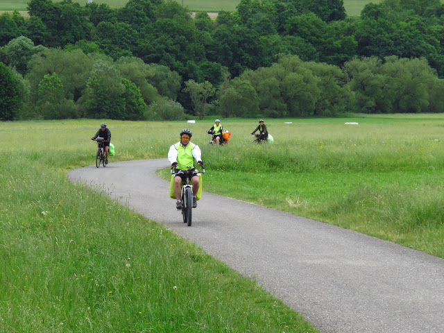
Despite the wide open spaces, it was far from lonely out there. This is not the superhighway of cycling that the stretch from Passau to Vienna is, but it is still a popular route and we passed cyclists regularly. In fact, we passed one group that appeared to be cycling from France to Austria (they had flags for France, Germany and Austria fluttering from the back of one bike) multiple times, as we did a tortoise-and-hare deal. We kept stopping to take photos, they kept cycling at their slower but steadier pace.
We were in SW Germany and passed a number of religious monuments in remote places along the way, plus one item that quite surprised us, this far from New England: a covered bridge. As you might have inferred from Louise's attire, it was a little brisk, high 50's F / 14-15 C.
The towns and cities were as interesting as the countryside, filled as they were with Fachwerk (half-timbering) and other interesting architectural details.
For our second day out, nature and man competed for our attention. The scenery had gotten quite dramatic, with limestone spires and cliffs that were sometimes several hundred feet high. But remote farmhouses and even more inaccessible castles were strong competition indeed.
One castle we passed perched, in fact, on top of one of these limestone monoliths.
These castle-like cliffs continued the whole day, all the way to the city of Sigmaringen, where cliff and castle once again merged, this time with castle quite the more impressive.
Schloss Sigmaringen was the home of one branch of the Hohenzollern family that provided the kings of Prussia and the two Emperors, Kaiser Wilhelm I and II, who ruled Germany from unification in 1871 to abdication in 1918. We took the tour and got the impression that this part of the family stayed largely out of politics, but continue to have power because they adapted to the changing times and became industrialists. This castle is still used by the family, but is no longer lived in, Members of the family in fact live nearby -- in several other castles!
They were still in residence here on September 8, 1944, when the Gestapo let themselves in and ordered the Hohenzollern family out. In their place came the government of France, at least in the minds of Marshall Petain, Pierre Laval and the remainder of what had been the collaborationist Vichy government. Vichy was in "enemy" (i.e. American, British and De Gaullist Free French) control. It was a bizarre existence for the Vichy French Government with, for example, a "Minister of Interior Affairs" who no longer had either an interior, nor affairs, to govern. One erudite blogger has recently written that "the French enclave of Sigmaringen was no longer life, not yet death." On April 24, 1945 the Free French Army arrived to liberate Sigmaringen. Most of the top Vichy leaders had snuck out of town just prior, but not for long. Before the end of the year, several had been caught, tried and executed.
We took the tour and it was worthwhile. The entrance is impressive from the outside, and also looking back from the inner courtyard. Within the castle was a mix of late 19th century innovations such as electric lighting and a bathtub with shower, and older items such as these Meissen porcelain statues and elegant chairs. There was very little mention of Vichy France, except for a brief description by our guide of that rapid departure of the family in September 1944.
After Sigmaringen the landscape became less dramatic, but there was still lots to see, such as the Danube of course, the towns, and quite a few stork nests, generally with storks in residence though they did not always cooperate in showing themselves when you finally pulled out the camera and pointed it at them.
There are always cyclists to look at and talk with. We did only the former with this large group that appeared to be on a school outing (and this was only half the group!), but chatted for 20 minutes with the family in the second photo below. They were on a 4-day tryout to get ready for a much longer trip this summer. The boys are 6, 8 and 10, and mom said they did well even on their long day, which was 40 km.
Our guidebook made a certain castle ruin looming down on the Danube sound interesting, so Jeff pushed Little Red, who is now almost 100 pounds of bike and baggage, up a steep hill so we could visit it. At the end of a dirt road there was the castle tower. A sign said to knock on the door of a farm next door for the key, but we chose to savor the view just from the bottom of the tower: the town and river, a dam being rebuilt, and a monastery across the valley.
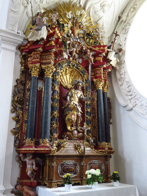
 Half an hour later we had crossed the Danube and poked in to explore the abbey, where we focused on a few details -- a curious face, a saint in high places, and an altar to . . . what? A swordsman? Couldn't figure out that one.
We had one more highlight before reaching our first major destination of Ulm -- the small city of Blaubeuren. It is renowned for the Blautopf, or Blue Pot. This is a natural spring with an intense blue color and no obvious inlet, for it is surrounded by very high hills in an almost complete circle around it.
 The day we were there the flow was quite moderate, but as the sign indicates, it can be quite voluminous -- up to 60 times as much as what we observed!
Starting about 30 years ago, some fairly brave cave explorers started solving the mystery of the Blue Pot, both with scuba gear and even a miniature submarine! So far an underground river of at least 1.2 km has been mapped, and an adjacent dry cavern through which the river perhaps ran at an earlier time. It's dangerous business, however, and the endeavor has even taken the life of one of the more highly trained explorers.
As if that wasn't enough excitement for one small town, there was also an abbey built in 1478, seen first from the street and then from inside the abbey courtyard, and a few other buildings that were 400-500 years old. The one with the green paneling up high was recently renovated and is now the town library.
 This first 240 km / 150 mi. leg of our journey ended in Ulm, where last year's exploration of the Danube had started. Ulm is home to the world's tallest church, the Ulm Minster. You can climb the tower, but last year we demurred since we were concerned it would wipe us out for the day's cycling. This time we were done cycling for the day, but we ran out of time. We had an 11:18 train to catch, and would need some of the 60 minutes 'til then getting to the train station and finding the right platform. So once again we just poked around the Minster and appreciated the fabulous wood carvings in the choir stalls near the altar, as well as the monumentality of the edifice itself and its exceedingly vertical pulpit.

 We have ambitious plans for this summer, and decided not to re-do the section of the Danube from Ulm to Passau. We'll pick up in the next blog entry with our brief overnight midway in Regensburg where we changed trains, and then take you along by bike from Passau all the way to Vienna.
3617, 14, 18


No comments:
Post a Comment