Sunday, July 31, 2016
Elbe Bike Route II: Riding with Friends and Crossing the Iron Curtain
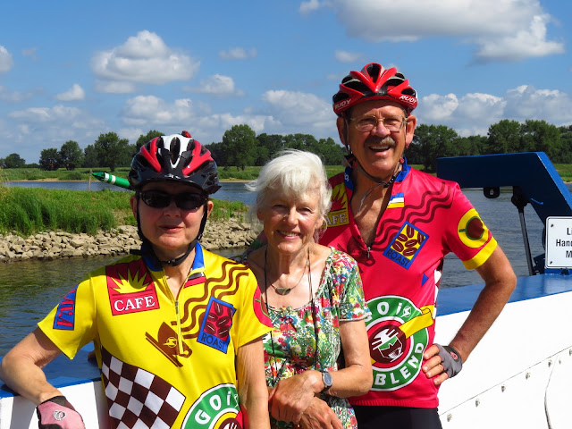
While biking along the Rhine last summer we made the acquaintance of Brigitte and Rainer at a Pension we were all staying at. We hit it off right from the start, and left the next morning pledging to stay in touch. We did, and they arranged their summer plans to meet us for some riding along the Elbe. We met up in Lauenburg, a town we showed you in the last blog entry, and headed upriver on nice paths past a vending machine for bike tubes and patch kits and then a Draisine, an abandoned railway line where you can pedal these devices 14 km out into the countryside and back. All that pedaling!!! Sounds like a lot of work to us!
Lauenburg is on the right bank of the Elbe, i.e. the northeast side, just inside Schleswig-Holstein. At the edge of town is the border with Mecklenburg-Vorpommern, a nondescript line on a map today but the infamous Iron Curtain during the Cold War. We crossed the river at Lauenburg and mostly stayed on the left bank, in the former West Germany. For the 20 km from Darchau to Hitzaker, however, we decided to cross to the right bank by a pair of ferries. In crossing, of course, we were going from the former West Germany to the former East Germany, and a border tower still watches ominously over this stretch of the river.
Nowadays there seemed to be little difference on one side or the other, at least from a bike seat riding dike trails. And if you want to chuck it all in and become a farmer in this idyllic place, we spotted quite a charming one that's for sale.
When we rode past the bridge at Dömitz, Rainer and Brigitte told us how it was the first to span the Elbe where the river forms the former border between East and West, in 1991-92. The bridge therefore is seen as a symbol of national unity. Close by, however, are the remains of a railroad bridge that was bombed in WWII and never rebuilt. The train line leading to the bridge was eventually pulled up, since there seemed no need for it once politics made east-west traffic obsolete. The remaining parts of the railroad bridge are well built and seem likely to last for a very long time as a contrary symbol, of a German disunity that is no more.
In several of these towns and cities we have encountered a very German tradition, a saying written on the front of a house. We were stunned when Brigitte started translating one from medieval Latin, since Jeff understood virtually none of it despite 4 years of Latin (albeit 50 years ago). Then we learned that the job she retired from was as a high school French and Latin teacher! Between Brigitte and Rainer we had various Plattdeutsch sayings translated for us as well, including this one from the town of Hitzaker, which says, in rhyming couplets, "When someone comes to me and says 'I please everyone,' I say to him 'Good friend, please do teach me this difficult skill'."
Up until now, the Elbe valley has been very wide and very flat with only one significant hill that we had to climb. We are now seeing more hills, most of them actually sand dunes. Two of them had viewing towers at the summits where we could get an even higher perspective. Those are in fact two other sand dunes that are still drifting on the other side of the river, behind Rainer and Brigitte. The second photo below is taken from a point where hill plus tower have gotten us over 50 m / 150 feet above the Elbe.
We are now entering the summer home for over a thousand White Storks. One of our first sightings was atop Schloss Gartow (look closely at the left-most chimney), the home still of a German count. Several villages yet to come are famous for storks, so you may just see a few more in our next blog.
We have now come to the end of Rainer and Brigitte's journey with us, the small city of Schnackenburg. It's been a good several days getting to know them better and to hear firsthand some of the stories of their lives in postwar Germany. Rainer had a particularly interesting point of view, for his folks had divorced and he lived with his mother in West Germany but saw his father from time to time in East Germany. We also very much appreciated various improvements in our German vocabularies and our understanding of German culture thanks to them.
Our friends have been to Schnackenburg before, and wondered if it had gotten any livelier than it was on their last visit. It had the misfortune to be tucked into a corner of the former West Germany, surrounded on three sides by East Germany (ehem. DDR ['former German Democratic Republic'] on the map). Few people other than the native Schnackenburgers saw any point in going there since there was nowhere else to go but the way you came in.
From what we could see, it has not recovered from its relative isolation, except for cyclists making their way up and down the Elbe looking for lodging and a meal. The demand is pretty much handled for now by a supply of one hotel which also runs the one restaurant, though the owner has recently purchased the former school and turned it into additional sleeping rooms, where we in fact spent the night "sleeping in class."
After waving good-bye to Brigitte and Rainer, who are headed back north to a town with a train station so they can get back home to Göttingen, we stopped to take a photo in "downtown" Schnackenburg when a cycle tourist came by, heard us speaking English, and stopped. Our new friend Carmen had spent a year doing an apprenticeship in bookbinding in London, and was eager to talk biking and to speak English. We ended up spending 20 or 30 minutes chatting!
But move on we did, reluctantly. Five km from Schnackenburg we came to the Stresow Memorial, where we will end today's blog entry. On May 26, 1952, the East German government decided to create a 5 km "protection zone" against Capitalist Imperialism where the border crossed land rather than the wide Elbe. Every town within 5 km of the border was demolished -- 15 in all. In the little community of Stresow, 4 families left all their worldly possessions and their home behind and fled to the West. The other families were resettled and their homes demolished.
At the border itself, it was decreed that there be a 10 m wide strip of double fencing and mines, then a 500 m area that no one was allowed to enter without a strict security clearance. The remaining 4.5 km could be used by farmers, subject to scrutiny by the border patrol. Louise is standing on the West German side of the fence showing us how far 10 m is to a would-be border-crosser. The sign says it all: "Attention -- Mines! Closed! Deadly!" As you can see, the mesh of the metal fencing is very small, to prevent fingers and feet from climbing it. The face was added recently as part of an art project by a local school.
Our next post will be from somewhere in the former East Germany! We're curious to see what it looks like now that the fences have come down.
Subscribe to:
Post Comments (Atom)


No comments:
Post a Comment