
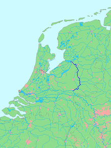
In keeping with our Rivers of Europe theme, it was time for our fifth river, the IJssel. This is one of the oddest rivers we have ever encountered, starting with its name. In Dutch, the letter combination ij is considered a single letter, so that ijs, "ice," becomes IJs Paleis, "Ice Palace," when you have to capitalize it.


After a bit our route turned left and over a veerooster. It means cattle grill, so-called because it looks like what meat used to be grilled on over an open fire. In fact, you almost always see sheep, not cattle, being contained by rooster, and today was no different. What you also don't see on dikes is lawn mowers, other than this four-legged version.


 The bronze map to the left shows what Zutphen looked like back in the day, when it literally had to defend itself from attack. During the Eighty Years War, when Holland broke free from Spanish control, it was conquered and reconquered several times, with unfortunate consequences for the defenders each of those times. Our next Hanseatic city, Deventer, shows the ancient outline of its defenses even today in the shape of its canals. Its Waag displays Deventer's wealth and grandeur for all the world to see. Our lodging was in the Hotel Fidder, which was once a convent. Deventer was a charming city and we had a very pleasant time walking down its many atmospheric streets, past many interesting doorways. Like all good Dutch cities, it also had lots and lots of bikes everywhere.


Next was the city of Zwolle, another charmer. It had a church with a tower we could climb for a few euros. 234 steps later, here's the view. In one direction is the Museum de Fundatie, with a newly-installed egg on its roof. In another direction was a typical line of buildings with interesting profiles and some decidedly less charming postwar buildings behind. Then there's the magnificent Sassenpoort, a 15th century city gate, seen from above and from street level. Also at street level was a charming organ grinder entertaining the crowds and making a few euros during the Saturday Market.


The history of the IJssel is far stranger than its spelling. The Romans noticed that the river came close to the Rhine, but without connecting to it. Engineers that the Romans were, they dug out a connection to allow their ships to journey further north. By the 19th century the Dutch got to work with dikes, weirs, dams and other devices to refine the flow, so that today the IJssel takes roughly 1/6th of the waters of the Rhine and sends them northward while the rest heads west. In 2012 a new system was completed to give even better control. When the Rhine is flowing hard, more of it can be diverted north to keep Rotterdam from turning into Europe's version of New Orleans.
The other end of the IJssel has, if possible, an even odder history. The river flowed into Flevo Lake until the massive St. Lucia Flood of 1287 (she personally had nothing to do with it -- it simply occurred on her feast day, Dec. 14). The lake's outlet to the North Sea was so widened and deepened that the lake became a large saltwater branch of the North Sea that the Dutch called the Zuiderzee, or "South Sea."
Many floods later, the Dutch decided to reclose the opening with a massive dam, the Afluitsdijk, that was completed in 1932. Once again, the IJssel flowed into a lake, now called the IJsselmeer. As it has gone from salty to fresh, it has become Europe's largest lake.
We biked across the IJsselmeer on a second dike, but we'll save that tale for the next blog. Today we'll take you down the river itself past the densest collection of historic towns in the Netherlands, thanks to that 650-year period in which oceangoing ships could travel through the Zuiderzee and up the IJssel. Seven cities along the IJssel joined the Hanseatic League and grew rich through trade in the 14th & 15th centuries. We visited the five largest of them.

We started by biking across the river near Arnhem, where 4 separate bridges stand, cheek by jowl, to carry trains, motor vehicles and bikes. On the far shore was the next part of our route, a road on top of the river dike. These are quite common in Holland and often, as here, allow car traffic, which is never bothersome as so few cars use it.

After a bit our route turned left and over a veerooster. It means cattle grill, so-called because it looks like what meat used to be grilled on over an open fire. In fact, you almost always see sheep, not cattle, being contained by rooster, and today was no different. What you also don't see on dikes is lawn mowers, other than this four-legged version.


Our first Hanzestad, or Hanseatic city, was Doesburg. It was the smallest, perhaps because it was the furthest from the sea, but it nonetheless has what is reputed to be the oldest Waag in the Netherlands. A Waag is a weigh house, where a government official would weigh cheese or other goods, which buyers and sellers could then know was reliable. Like many Waags, it has become a quaint and cosy restaurant.

Our overnight was in Bronckhost, Holland's smallest city. It got city rights in the 1200s, but unlike most other cities, it just never grew. Sometimes it just happens that way. Today it has 171 inhabitants. We picked up a walking map and took a stroll down the Main Street and were out in farm country in 4 minutes. It was a wonderful walk, however, past an old windmill and a typical house-barn combination. Back in town we noticed activity just under the thatch roof of a house. A dozen nests clung to the walls, each with one or two baby swallows waiting to be fed. Every now and then mom or dad would show up and do a five-second hand-off, or rather beak-off, of food.


Our next Hanzestad was Zutphen, where we looked through the old city gate at a building that now houses a wine shop. We walked through then looked back at the fancier front of the building and the impressive tower on the city gate. Nearby was St. Walburga's church, begun almost 1,000 years ago and often remodeled into a grander and grander version of itself. Damaged in WWII, it was not fully restored until 1998. A very ancient wall painting told the story of the three princes and the three dead people. When they meet in the woods, the deceased tell the living "What you are, we were. What we are, you will be."


Next was the city of Zwolle, another charmer. It had a church with a tower we could climb for a few euros. 234 steps later, here's the view. In one direction is the Museum de Fundatie, with a newly-installed egg on its roof. In another direction was a typical line of buildings with interesting profiles and some decidedly less charming postwar buildings behind. Then there's the magnificent Sassenpoort, a 15th century city gate, seen from above and from street level. Also at street level was a charming organ grinder entertaining the crowds and making a few euros during the Saturday Market.


Before our final city, we headed through the countryside to Giethoorn past several clusters of what appear to be a type of heron. In a few places there were even platforms that had successfully attracted birds to nest.


Giethoorn is a small place that has attracted the attention of Chinese tourists like almost no other spot in Holland -- about 1/4 million per year! It is one of a handful of villages that lived for eons entirely by water. No roads, only canals and footpaths, plus nowadays some 180 footbridges. Need to move your cow to a new pasture? Put some hay in your boat and row her over. Nowadays the thing to do is to rent a boat and to cruise the intricate canal system. One narrow one-way section is jammed pretty much all day. We found a hotel right on the waterway that rents electric boats and canoes, and paddled 6-7 miles the afternoon we arrived and again the next morning before biking on to our next destination. We had no competition for the canoes, but the so-called whisper boats were all rented out within an hour of opening time. As you can see from the photos, it was charming. And why all the Chinese, you ask? Our best guess is that they can't believe there's a place that can resist change so well, and want to see it before it gets paved over.


The boating was not entirely in the village. We were able to get out far from town, though never very far from other boats. In fact, well out from town, there was even a floating ice cream shop!


150 km by water from the Rhine, 200 by bike with our detours, and we were at our last Hanseatic city, Kampen. We spent two nights here since rain was predicted, accurately as it turns out. But by late afternoon on our "rain day" the sun was out again and we wandered this charming city, perhaps the best of the five we visited. Here are a few streets and alleys as a warm-up:


Then there are the three city gates. The first one, by the river, is the oldest. The other two were built in 1465, then both were moved and rebuilt in 1615 when the city expanded inland and the city walls had to move as well.


The old city hall is another charmer. Then there's that tower with a cow on a pole. Seems a farmer saw some moss up there, thought it was grass, and figured out a way to hoist his cow up to eat it. Up went the cow and the cow stuck out its tongue. The farmer thought it meant she liked her meal. In fact, it meant he had successfully choked his cow to death, and Kampen was the butt of jokes for decades after.


As with so many of our hotels in the Netherlands, the owners provided indoor storage for bikes. You can see how many folks travel by bike here from the company our tandem had in the bike room!

From our room overlooking the river, we said goodbye to the IJssel. We'll pick up the narrative in the next posting as we head across a province that wasn't here when we were born -- it's land reclaimed from the Zuiderzee.


No comments:
Post a Comment