
The first full day there had good weather, so we left the heavy panniers in the apartment and headed into the hills. Yes, the Netherlands has three hilly areas: the dunes along the North Sea, the Hoge Veluve inland dunes north of Arnhem, and the marlstone hills of Limburg Province, in the bottom right corner of the country. Limburg is the only place in Holland where the elevation exceeds 100m (330') above sea level, with one hill getting up to 1,050'. It's hard to see from the photo, but the trail is climbing at 4-5%, and soon after got to about 8%. Yes, we finally found a hill in Holland we had to walk up!


The area is underlaid with marlstone, a generic term for rocks that are 1/3 to 2/3 clay, 1/3 to 2/3 calcium carbonate, or to put it another way, a fairly soft limestone. Nonetheless it has been used as a building material here since the Romans started mining it 2,000 years ago, and there are an astounding 250 kilometers of excavated tunnels just under Valkenburg, plus similar if smaller networks under other cities in the area. One group, Survival Limburg, will put you and the troglodytes of your choice in a 25 km subset of the cave system with a candle and a map of the 406 passageways. Jeff poked his head into one cave entrance far enough to capture the feeling, momentarily, which was quite enough thank you very much. Of greater interest was the Kasteel Schaloen just east of town. Its current fairytale look is probably due more to an 1894 "renovation" than to its ancient age (parts of it are 800 years old).


Jeff spends 20-30 minutes most days figuring out our next stays. We keep an eye on the weather forecasts and book 1 to at most 3 days in advance, using Booking.com almost exclusively because it works well for us. He'll check that the location is near our route and/or places we want to see, particularly when we're staying an extra day or two for sightseeing. He also considers the customer ratings and often reads a few customer reviews. As a result, we've had no unsatisfactory experiences at all, and quite a few good ones. One of the very best was the Sandton Chateau de Raay in Baarlo. The Sandton folks took several buildings from a former convent, renovated them gloriously and connected them with glass atria. Our wing actually had a moat partway around it, and the serenity of a cabbage farm outside the spacious room they upgraded us to. Hey, we're Sandton fans now!


Our river-following scheme had us taking the Maas to the area near Nijmegen, where the river bends from mostly north to mostly west-flowing. From Nijmegen we would then take the IJssel River further north. Looking ahead in our guidebook to see to what there was to look for, we noticed the info about the Vierdaagse, held each year in "late July." Uh-oh, it's late July! Thanks to the Internet, we quickly had the bad news -- we were headed right toward a lodging nightmare.
The 4daagse, as it is sometimes written, is a 4-day walking event. 46,000 signed up for this year's edition, committed to walking 30-40 km per day for four consecutive days (42,684 actually began, and 40,092 completed 120-160 km (75-100 mi.), a remarkable 96%) Now a large percentage of these hardy folks would be driving or taking the train from home each day (this is Holland and the train service is amazing), and many more would perhaps be camping. But if even 10% of those 46,000 folks needed a place to stay, they obviously booked it months ago, for many miles around Nijmegen. At our current pace, we were looking at an arrival on day 2.
And so we altered course 100 km before Nijmegen, and headed northwesterly toward the city of two names. Officially it's 's Hertogenbosch, meaning "the Duke's Woods" (though the duke and the woods are long gone), but most Netherlanders call it Den Bosch. We took a ferry westward across the Maas, with the usual Summer load in Holland of more bikes than motor vehicles. For the first time we followed LF (Landelijke Fietsroutes) long-distance bike routes that crisis-cross the Netherlands. In the flat countryside it didn't matter that we were no longer following a river, though we did ride along the Wilhemina Canal for 25 km. At a bridge along the canal we took a photo to show how much of the bridge width was dedicated to cyclists vs. motorists. Then we noticed a sign nearby that is part of the National Liberation Route. It should really be called the Attempted Liberation Route, for it documents the tragedy of Operation Market Garden, Gen. Montgomery's ill-conceived plan to seize "the bridge too far" across the Rhine at Nijmegen, about 80 km from here. The Brits tried to seize this bridge over the Wilhemina Canal, but the Germans blew it up first. The photo shows the temporary bridge the British put in anyway. If you look carefully, you can see the same gable-end building on the far left in both the old photo and in ours.


We were astonished to see how close we got to den Bosch before we left the greenery. This photo was taken 2 km from the cathedral in the very heart of the city! We had two grand adventures in Den Bosch but will put them off to the next blog entry where we will add a third adventure in Arnhem.

We'll close with a few shots from our 71 km ride from the one to the other, such as this attractive condo on the northern edge of den Bosch, or this color-confused goat. We also worked on our Dutch, making certain we knew that Wacht means "watch out!"

We'll close with a few shots from our 71 km ride from the one to the other, such as this attractive condo on the northern edge of den Bosch, or this color-confused goat. We also worked on our Dutch, making certain we knew that Wacht means "watch out!"


This is an area the Dutch call "Riverland" thanks to the complex of large rivers. The map will hopefully help you make sense of it.
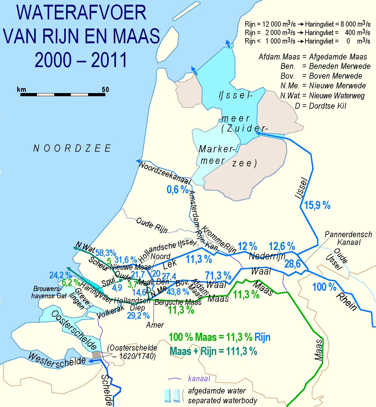
In the center is the Waal, carrying the largest proportion of what was the Rhine. Above it is the Nederrijn, the next-largest portion of the Rhine. Then below the Waal is the Maas. All three are interconnected with multiple canals, and all of them change names as they flow to the sea. You almost need a course on it to sort it all out, though this one map is a darned good start.
So we did get to see the Maas one more time, riding eastward along it for 10 km and then crossing it by ferry. We then rode through the Land Van Maas en Waal for a while before doing a few km on the Waal River, this time crossing on a bikes-only ferry. The ferry captain had to time things perfectly, for within 2 minutes of our arrival on the opposite shore, 2 large freighters had gone by eastbound and a third one westbound. It was a Sunday again, so we also had to keep watch for large bike clubs in their matching jerseys, whizzing along several kph faster than us. Nonetheless, there was always company nearby for us in the slow lane.


It was an easy 71 km, just short of 45 mi., since we had a tailwind all day. That was the good news. The bad news was that it was just a one-day break between a rainstorm we survived in Den Bosch and one we were about to work around with a non-biking day in Arnhem. We'll describe our special adventures in these two cities in our next chapter.

No comments:
Post a Comment