
 And this is an amazing place to bike. It is attractive and historic and friendly, and the bike facilities are beyond belief. Even some of the public art is bike-oriented! Where else could you find twin drawbridges where one span is for cars and a separate one dedicated solely to bicycles and pedestrians? Or a ferry primarily, sometimes even exclusively, for cyclists?


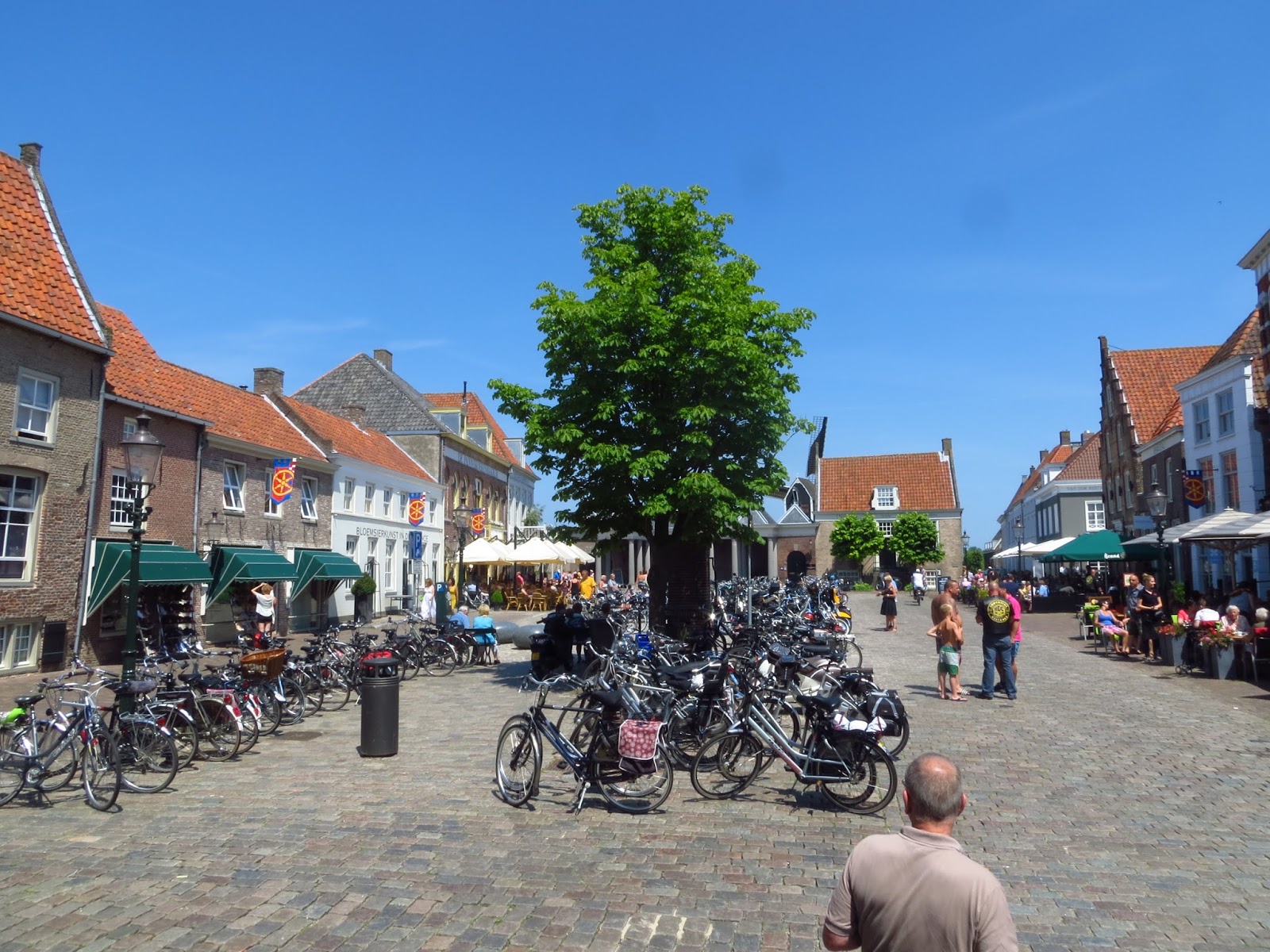
There are a lot of bicycles and a lot of cyclists in Holland and Belgium. We rarely biked anywhere without seeing others on their bikes going to work, school or shopping, almost never with lycra or helmets to be seen. A remarkably large percentage appeared to be in thier 60s and older -- in fact, a dream start to retirement in Holland is considered a long bike trip!
Almost every day we saw long-distance cyclists like ourselves, with tell-tale bulging panniers, and on weekends the 20- and 30-something crowd, usually in bunches, usually single-sex and often but not always male, almost always in what we think of as full cycling regalia of helmet and bright-colored bike clothes.


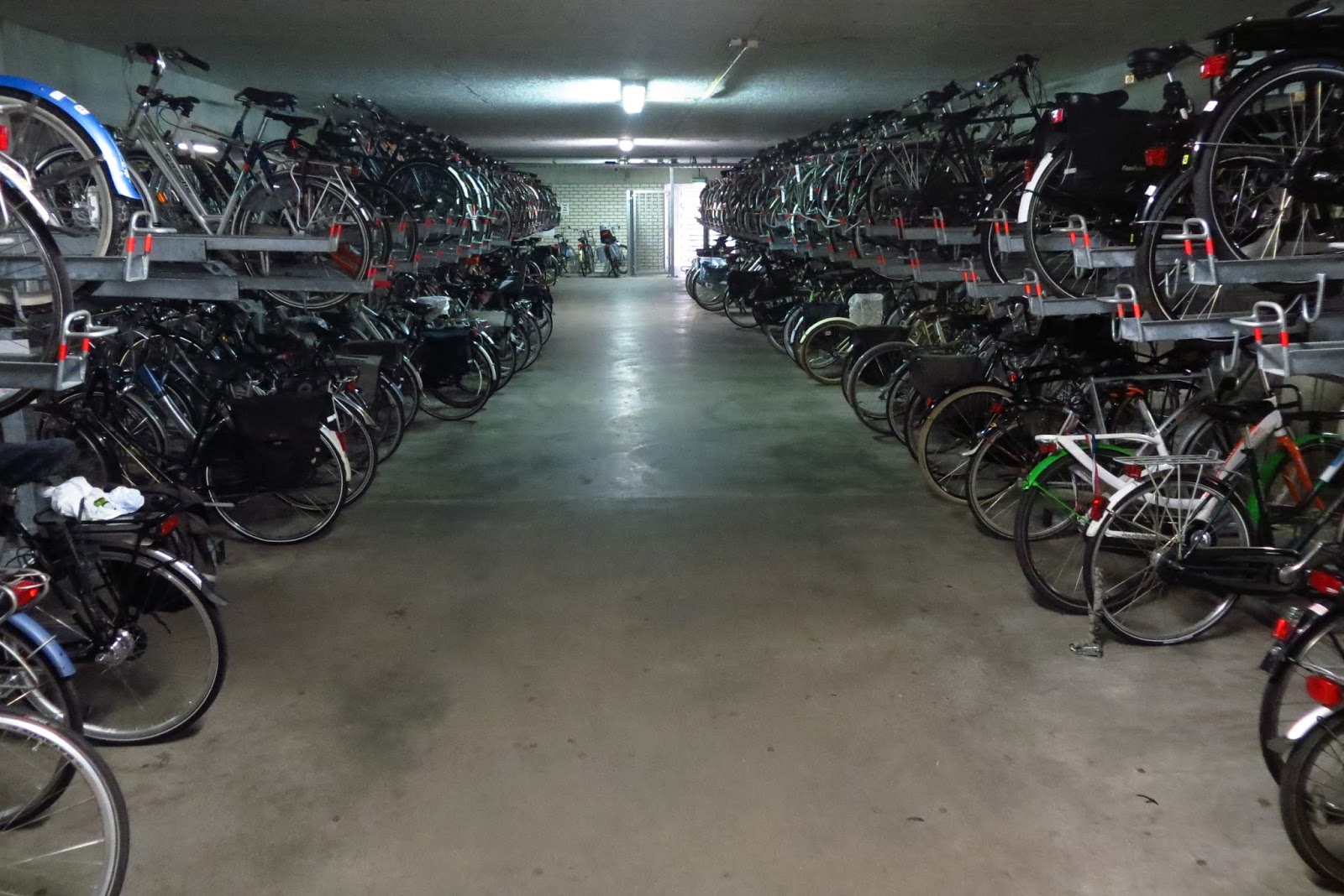
And everywhere a bike could be parked, they are parked. In amazing numbers. Sometimes even underground, where our tandem rested awhile under the Groningen Public Library (this is just one of three lanes of parked bikes there), or double-stacked at train stations.


Lodging has been easy to find and book, and only once have we stayed somewhere where there wasn't a restaurant on the premises or a few doors down the street. This was a small town where we rolde all of 2.5 km to the adjoining small town, which had a Chinese-Indonesian restaurant. We al;so found universally comfortable lodging at an average cost of €85 ($115) per night. With only one or two exceptions, this included and all-you-can-eat breakfast buffet that always had meat and cheese, almost always eggs and fruit, plus much more. No "continental" breakfasts here!
Now, let's share our observations about the biking.
Bike Paths
 Almost 2/3 of our miles in Holland have been on bike paths, virtually all the rest on relatively quiet country roads. Trails come in two main flavors, either next to a road, or not. A large percentage of the faster roads connecting towns and cities have bike paths adjacent to the roadway, often on one side of the roadway but occasionally on both. Bike traffic is two-way regardless of which side of the road you are on. Since roads don't usually dilly-dally about getting from Point A to Point B, neither do these bike paths, so they are a relatively fast way of getting about, with the caveat that one does have to slow down at roundabouts (which have their own bike paths) and roads that cross the path to enter the road you are following. Then there are other riders. If there are two of them, the
odds are overwhelmingly in favor of them being side by side. If they're a group of four, they'll ride in
box formation, making it even harder to pass.
In short, one rarely gets to hammer away at a fast clip without
interruption as one would going down the shoulder of a highway in, say, Montana.
Almost 2/3 of our miles in Holland have been on bike paths, virtually all the rest on relatively quiet country roads. Trails come in two main flavors, either next to a road, or not. A large percentage of the faster roads connecting towns and cities have bike paths adjacent to the roadway, often on one side of the roadway but occasionally on both. Bike traffic is two-way regardless of which side of the road you are on. Since roads don't usually dilly-dally about getting from Point A to Point B, neither do these bike paths, so they are a relatively fast way of getting about, with the caveat that one does have to slow down at roundabouts (which have their own bike paths) and roads that cross the path to enter the road you are following. Then there are other riders. If there are two of them, the
odds are overwhelmingly in favor of them being side by side. If they're a group of four, they'll ride in
box formation, making it even harder to pass.
In short, one rarely gets to hammer away at a fast clip without
interruption as one would going down the shoulder of a highway in, say, Montana.


Most
trails are asphalt, but maybe 1 km in 20 has been on pavers such as in the next
photo. Only about 10 km of our 1250 km
have been unpaved, and these were comparable to the "packed
limestone" trails that are common in the U.S., especially in
Wisconsin. The second photo shows the
most difficult km of the summer, since the trail had soft spots wherever a
farmer crossed it from the sandy road on the right to his fields on the left,
requiring us to dismount to be sure we didn't sink in and have a tumble off the
bike. The third and fourth photos are of
dirt roads with paved bike paths next to them, something we encountered half a
dozen times. Only in Holland!


Most of
the bike paths that we rode, however, followed canals and dikes and sometimes
perhaps only an old cow path. They often
wander, but make up for it with scenery.
As in East Friesland, Germany, sheep take care of lawn maintenance on
many of the dikes. Those sheep guards
are a little easier to bike across than cattle guards we've encountered in the
U.S., but we've never had animal traffic jams in the States.


Country
Roads
The large
majority of country roads we've been on so far have trees lining one or both
sides. Very attractive, and some help on
a windy day though dense vegetation alongside the road does a better job. When it finally warmed up (for the first 3
weeks in Holland it never got above 18 C/ 65 F), these tree-lined roads were
also a welcome bit of cool shade. Dike
roads, by contrast, never have shade. In
some areas, especially along the North Sea and along the IJsselmeer, the dike
roads ran at the base of the dike, on the inner side. More than once, this proved helpful as it
helped shade us a bit from a strong cross wind.


While
generally quiet, these roads do have
car and truck traffic in both directions, even when they are nothing more than
a narrow dike road. When motor vehicles
meet, they slow a bit and drive off their respective sides of the road. It sometimes felt a bit close when they
passed us, but we always somehow fit.


 It seems
like about 90% of the country roads have been smooth asphalt, about 10% brick
or pavers or, in a very few places, rough cobblestones. In small towns and cities both, the percentages
reverse. Pavers and bricks are bumpy and
therefore slower -- partly because of greater road friction, mostly because
it's not comfortable otherwise. But
then, we want to slow down and appreciate all that great Dutch architecture, so
no problem.
It seems
like about 90% of the country roads have been smooth asphalt, about 10% brick
or pavers or, in a very few places, rough cobblestones. In small towns and cities both, the percentages
reverse. Pavers and bricks are bumpy and
therefore slower -- partly because of greater road friction, mostly because
it's not comfortable otherwise. But
then, we want to slow down and appreciate all that great Dutch architecture, so
no problem.

Towns and
cities frequently have one-way streets, but we have yet to find a single one
that did not have a "Fietsers Uitgezonderd" ("Bicycles
Excepted") sign, no matter how narrow or busy the street. Again, this is not for the faint of heart,
but the Dutch are used to squeezing past each other. Just follow the British maxim, " keep
calm and carry on," and you'll be fine.

Hills and
Wind
Cyclists
have a love-hate relationship with hills.
They can be hard to climb and they slow you down, for a hilly route is
always slower than a flat route of the same distance. On the other hand, they change your cadence
and speed, now slow, now fast, and can make a ride more interesting for that
reason alone, particularly when the hills are gently rolling. Then there are those who enjoy the challenge
of besting a steep hill, or hurtling down the other side. And nothing beats the top of a hill for
views.
If for
any of these reasons you like biking where there are hills, you will be
disappointed in Holland. Only in the
sand dune areas along the west coast and in the Veluwe, in the eastern part of
Gelderland Province, did we find anything that looked like a hill. You can do a 100 km / 62 mi. ride on a bike
with an altimeter and record maybe 10 m / 30' of climbing for the day, all of
that from bridges over highways or train tracks. There are supposed to be hills in Limburg
Province, in the SE corner of the Netherlands, but that is one of the 3 provinces
we did not get to. It was also quite
flat in the small part of Antwerpen Province of Belgium that we explored.
We
worried before coming to the Netherlands that the wind would be a big
problem. It turned out to be less of a
problem than we expected. For one thing,
we had a lot of luck. When we were
headed west from Germany to the IJsselmeer and southwest from the Veluwe to
Antwerp, we had about the same number of headwinds as tailwinds. In our big push eastward from the west coast
to the Veluwe, we had tailwinds every day.
Now 'headwind' and 'tailwind' are relative terms, since in Holland you
rarely go very far in a straight line with a bike, nor with the wind straight
at or straight behind you, but all in all, there were only a few days where we
truly felt we had to battle the wind most of the day, or had it as a major
ally.
And when
you do have to battle the wind, you simply work a little harder, and go a bit
slower. One day with a strong headwind
(~ 28 kph / 18 mph) while we were on top of a dike, we were down to a ground
speed of 18 kph / 11 mph. But not long
after, we got off the dike, and frequent stands of trees broke the wind up, and
our speed improved. In still air we
generally did 25 kph / 16 mph, and only hit 32 kph / 20 mph with a stiff
tailwind. But with many reasons to slow
down -- to safely make a sharp turn, to look for road signs, to cross busy
highways, to pass other cyclists, to ride on a brick-paved street, or even just
to sight-see -- we rarely had the throttle full open for long.
In short,
wind was occasionally an annoyance, but not the obstacle we thought it might
become, and it did vary our pace as we turned with or at angles to the wind,
much like hills sometimes do.
Route
Finding
How did
we find our way about? Primarily with
the "Knooppunt" system. It's
designed primarily for the recreational cyclist and has its frustrations, but
it did get us around the country quite safely and scenically.
 "Knooppunt"
literally means "knot point," and a knooppunt map looks something
like a macramé
design. The idea is that you start at,
let's say, Knooppunt 36 and want to head to the town of Stadskanaal on the map
to the right. At Knooppunt 36 you look for an
arrow telling you which way to head to #37.
When there you look for the arrow to 38, then on to 45 and finally to
77. The second photo is of a suggested
round trip (Knooppunten 86 and 84 are actually a few blocks apart in the same
starting town). Just follow the numbered
signs.
"Knooppunt"
literally means "knot point," and a knooppunt map looks something
like a macramé
design. The idea is that you start at,
let's say, Knooppunt 36 and want to head to the town of Stadskanaal on the map
to the right. At Knooppunt 36 you look for an
arrow telling you which way to head to #37.
When there you look for the arrow to 38, then on to 45 and finally to
77. The second photo is of a suggested
round trip (Knooppunten 86 and 84 are actually a few blocks apart in the same
starting town). Just follow the numbered
signs.
It's
often not the shortest or fastest way, but it is effective in delivering you to the destination so long as you succeed in always finding
and following the signs. That's the
rub. There may have been one day in
those three weeks when we found every sign that marked a turn, but we can't
actually recall such a day. Twice we
rode an extra 10 km thanks to missed turns.
Writing down the distance between knooppunten did help ensure we didn't
go too far out of the way. Nonetheless,
two or three times either our map or the sign was dead wrong, or a sign was
unquestionably missing. One day we had a
nice tail wind, so our bike computer recorded our average speed after 24 km of
riding as 24 kph / 15 mph. But it
calculates speed only when the wheel is moving, and we had actually taken 1 hr.
20 min. to do those 24 km. The extra
time had been spent in 5 or 6 stops to look at our map or to go back and look
again at an intersection where we thought we might have missed a knooppunt
sign!

The
payoff was greater than the frustrations, however. When the route seemed to wander, it was
almost always to good purpose, such as to route us past a medieval church or
down a quiet lane. We never worried
about biking into large cities, so confident did we get that the Knooppunt
system would find us a safe and interesting route in and out. We rode in quiet paces we never could have
found otherwise.


Although
most knooppunten have signs showing the system in that area, we needed more
help than that so we purchased 4 maps at €5 ($6.50) per map to cover where we expected to ride in
Holland, and found a similar map for the Antwerp area when we entered
Belgium. Jeff also looked at the next
day's route the night before on http://routeplanner.fietsersbond.nl/, a web site that has
amazingly detailed bike maps of the whole country. About halfway through our time in Holland he
started making screen shots of these more detailed maps on our iPad, to be
consulted during the day if and when we got lost. We continued to get lost, of course, just not
as badly or for as long.
 There
are, by the way, two alternative ways of getting about. One is "mushrooms," little
mushroom-shaped markers at intersections frequented by cyclists. However the writing on them is small, the
mushrooms sometimes a challenge to find even when they're there, and they are
often not there at all. There are also
white signs with red lettering pointing to nearby cities, generally routing you
to cycle paths alongside larger roads.
We followed these a few times when the knooppunten wandered too much,
and thus struck a balance between fast and scenic ways of getting about.
There
are, by the way, two alternative ways of getting about. One is "mushrooms," little
mushroom-shaped markers at intersections frequented by cyclists. However the writing on them is small, the
mushrooms sometimes a challenge to find even when they're there, and they are
often not there at all. There are also
white signs with red lettering pointing to nearby cities, generally routing you
to cycle paths alongside larger roads.
We followed these a few times when the knooppunten wandered too much,
and thus struck a balance between fast and scenic ways of getting about. And, last
but not least, there is yet another option, the LF (long-distance bike route)
system, which mostly strings together knooppunten into routes that go sometimes
hundreds of kilometers, such as LF 10, which follows the North Sea from Germany
to Belgium. We liked to follow LF
routes, since that gave us two signs
to look for at each intersection, also using the green-on-white color scheme of
the knooppunt signs.
And, last
but not least, there is yet another option, the LF (long-distance bike route)
system, which mostly strings together knooppunten into routes that go sometimes
hundreds of kilometers, such as LF 10, which follows the North Sea from Germany
to Belgium. We liked to follow LF
routes, since that gave us two signs
to look for at each intersection, also using the green-on-white color scheme of
the knooppunt signs.
Where to
Go
We
believe in guidebooks, at least as starting points for finding interesting
places to see. We relied heavily on a Lonely Planet guide, and were only
disappointed once when it told us to see a museum that had closed for
renovations a year earlier. Otherwise it
gave excelent advice, and we never regretted any of our choices of destination
based on its advice.
We also
found that the routes the Knooppunten directed us to also gave us a good
cross-section of the Netherlands, a mix of farms, nature preserves, small
towns, large cities, and canals, canals, canals. Our "budget" was 200-300 km/wk., so
we would rough out where that might take us, where we might want an extra day
or two, and then actually did the booking of hotels 1-3 days ahead of time,
depending on the weather forecast. For
us it was just the right pace, with only one 80 km/50 mi. day and one other
that was slightly over 72 km/45 miles. Our ideal was 35-50 km in a day.


This is
less than we typically have ridden in the States. In part it's that we found more interesting
places to visit and/or photograph along the way, but also because it's
virtually impossible to crank out miles the way you do in the U.S. You slow to look for and read Knooppunt
signs, to get around roundabouts, to cross busy roads crossing your bike path. You slow for cars coming at you on a narrow
road, for slow cyclists you want to pass, for brick roadways as you enter a
town. You get lost, you pull out a map,
you get really lost and pull out the iPad with screen shots of the more
detailed map. In short, you slow down or
stop more often than when you leave an American town by bike and see that the
next town is a straight shot of 15 miles down the shoulder of the highway. But it's all great fun. No complaints, it's just a different style of
biking.
Language
We rarely
met a Dutch person who was not fluent in English. It was written
language we struggled with. Signs in
museums and at popular tourist destinations were rarely in any language but
Dutch, while traffic signs and everything in supermarkets were uniformly
monolingual. More than once we pulled out
our iPad in a supermarket or in a restaurant to use the Dutch-English
dictionary we had loaded. "What's
'Franse Uiensoep' again . . .?"
(btw, it's French Onion Soup). We
quickly learned what "Geen Fietsen Plaatsen" ("place no bikes
here") meant and acquired a vocabulary of maybe 100 words, 90 of them food
items. Jeff also could sometimes figure
out a word from its similarity to German.
In short, it was a challenge, and we did emerge from some museums with a
little less insight than we'd hoped to acquire, but we survived, and mostly
were able to laugh about our guesses as to what various signs were trying to
tell us.


All in
all, we loved our cycling adventure in Holland, and found the small part of
Belgium we saw to be equally interesting, equally bike-friendly, even equally
flat. What's the biggest problem we've
discovered? That it will be hard to plan
bike trips in the U.S., knowing that there is this wonderful place beckoning us
to return and to explore even more of it.
Now off to England for our 19-day adventure there!

No comments:
Post a Comment