

This week found us visiting Fremont OH, named after John C. Fremont, "The Pathfinder." First a few words about the town and the man, then we'll say a bit more about how we do pathfinding.
 Fremont started out as Lower Sandusky, confusingly located half-way up the Sandusky River between Sandusky to Upper Sandusky. As the furthest point of navigation up the river from Lake Erie, it prospered early and attracted an energetic entrepreneur, Sardis Birchard, and his ambitious lawyer nephew, Rutherford Birchard Hayes. Hayes convinced the town to rename itself after American explorer John C. Fremont, a prominent Whig politician and later the first Republican candidate for President. Sort of like an eager Republican in the 1990's talking a town into renaming itself after John McCain.

We visited his home in Fremont, shown above, and the nation's first Presidential museum on the grounds. They had on display the 19th century equivalent of Air Force One, except that Hayes got to keep the carriage after he left the White House. Like the current resident, he had a 10-year-old daughter, as well as a teenaged son living with him then. When you're the Big Guy's10-year-old, things arrive like this wonderful doll house. Incidentally, Hayes liked to call his wife his "first lady," and the name caught on for future -- errr -- "First Ladies."
Fremont got his nickname the hard way, finding paths through the wilderness. Too bad he didn't have Google Maps. For us, it's revolutionized pathfinding.
After readjusting the starting point to Toledo (see the last blog entry for why...), we next looked at overall distances, figuring that 150 miles a week by a direct route between points of interest would translate into 200-225 miles by our wandering bike routes, a realistic goal. Then we start looking at connecting the dots with paved roads that have adequate shoulders, low traffic or both, hopefully not too hilly.
Starting with Toledo, for example, we looked first at riding over to Lake Erie and following the shore. Didn't work. Biggest problem was Sandusky, which has a large amusement park that has inflated all the motel prices for 50 miles in each direction. Next we looked at heading southeast toward Fremont, but Google Maps showed us problems with that approach. Here's how: We start by proposing a day's ride, e.g. Toledo to Fremont, and seeing what the distance is. First problem was that it was a little far for our first day out, given the need to start slow until Jeff's wrist shows it's up to the task. Bigger problem was when we looked at the proposed roads with "street view" and saw that they were roads we did not want to ride.
How? Google has photographed gazzilions of roads across the country, and you can actually see what they look like. In our case, we're looking primarilly to see if they have a shoulder, and secondarily if we can get a sense of how busy they look from the traffic the photos show (a dicier conclusion, but you take what you can get).

Here's an example of what we're looking for, and which Google Maps helped us find when we decided to leave Toledo to the southwest to take advantage of a rail trail, then turn east once we were far enough to the south of Toledo to be out of its traffic congestion. On this and several other roads we took in this part of Ohio, we had a car pass us maybe once every 15 minutes.
Good roads and the occasional bike trail are of course necessary, but so are places to spend the night. To figure those out, we look at the map and see what town we've established as an overnight spot, then look at where we would go to the next day. We look 30-40 miles in the general direction we want to go, and ask Google Maps to find us "hotels and motels" and/or "B&Bs." When we find a place that might work, we can usually find a link to their website or a phone number. Before we book a room, however, we ask Google Maps to search nearby for restaurants, since the routine is to arrive at our hotel or B&B, shower and wash out the clothes we've biked in, get into our "street clothes" and walk to dinner.
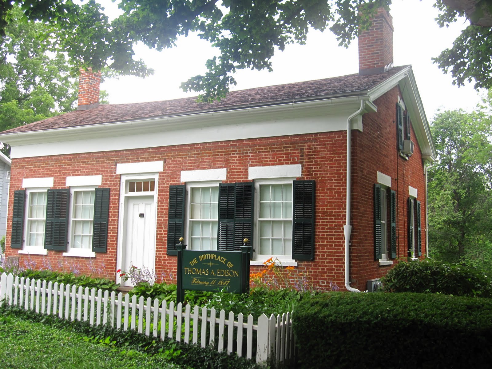
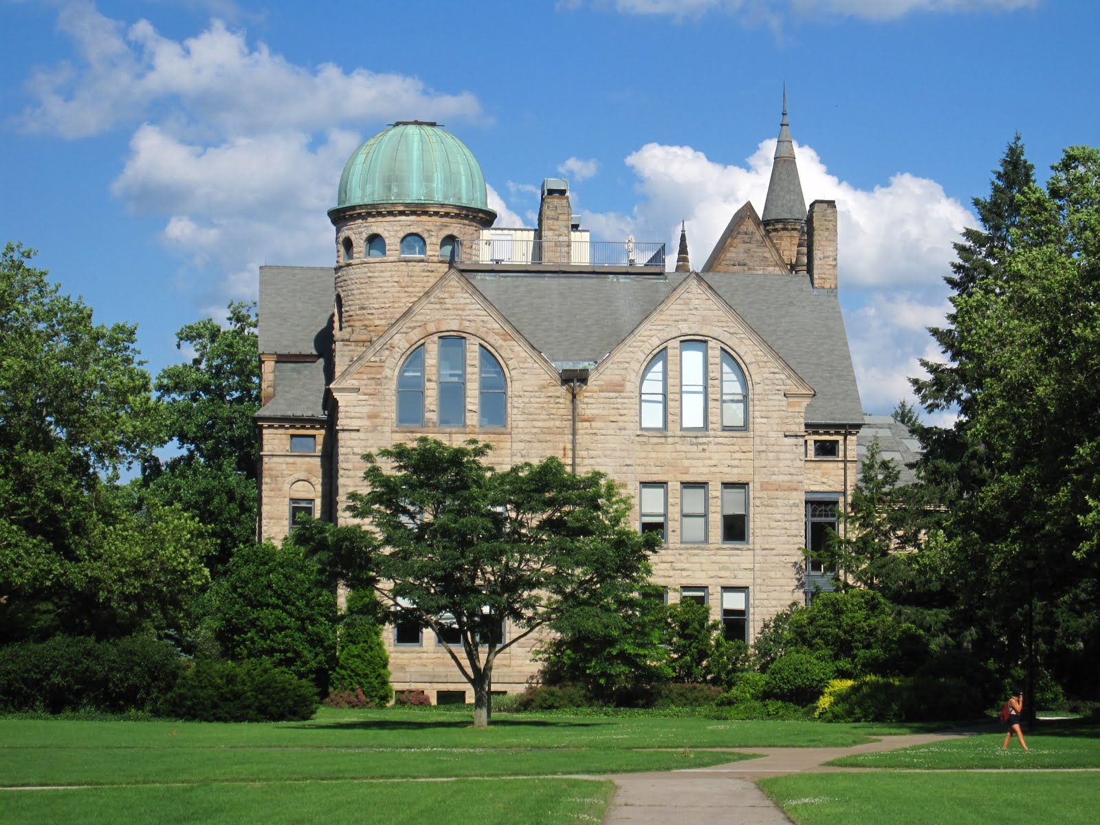
Meantime, of course, we're also looking for info on interesting places to visit. In our first week, we rode the Cannonball Rail Trail to Grand Rapids OH, where we stayed in a B&B that was once a flour mill. Then we visited Bowling Green and rode around its extensive but extremely quiet campus. Third "hot spot" was Fremont, which we discussed above. Then in the next two days we visited the Tom Edison birthplace and Oberlin College.
Meantime, of course, we're also looking for info on interesting places to visit. In our first week, we rode the Cannonball Rail Trail to Grand Rapids OH, where we stayed in a B&B that was once a flour mill. Then we visited Bowling Green and rode around its extensive but extremely quiet campus. Third "hot spot" was Fremont, which we discussed above. Then in the next two days we visited the Tom Edison birthplace and Oberlin College.
We'll close today's blog with some houses in Fremont that are demonstrative, however, of many of the small towns and their sumptuous late-19th century architecture that we've seen all across Ohio,

then Young Tom's birthplace and a statue in the town square that seems to suggest that bright young lads should ignore their mothers' teaching,

and finally a few of the buildings at Oberlin. 

Oberlin was a rabidly anti-slavery college and hence a major stop on the "Underground Railroad," commemorated with this creative sculpture.

 It was also a place Louise thought long and hard about attending before deciding on U. Mich. because of the substantial price differential. We looked at the current student catalogue, and they now esimate it takes $52,000 a year for tuition, fees, room and board! Wow! Glad we got through college when we did! Couldn't afford it now!
We'll tell you more about Ohio in our next blog, hopefully fairly soon as we're a week in arrears in keeping it current.

No comments:
Post a Comment