We started with a tramp on the upper Waihou Stream,


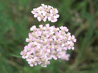
which was just another small, attractive watercourse as the trek began, but changed into a rushing little runnel as we tramped upstream, then displayed amazing shades of blue highlighted by profusions of minuscule pink flowers floating on the edge. Add in some wildflowers along the track and you have a nice day indeed.


That was in a rural area about an hour west of Rotorua, following which we drove north on roads through the Waihou Valley that were,

at last, bike friendly. We were paralleling the Kaimai Range, on roads relatively flat, straight and devoid of traffic. Further north the Kaimai becomes the Coromandel Range, the steep spiny center to the Coromandel Peninsula,

and it was there that we captured these next two images that might be entitled "Why We're Not Biking the North Island."

Alas, far too many of the roads we've driven have been just this twisty and shoulderless. That said, they've been very fun to drive in our skinny subcompact, an admission that's a little embarassing for us dedicated cyclists to make, but gosh, they were fun to drive. We are going to bike the South Island starting next month, we'll report back later on how that went.

After a very quick stop to see the unimposing but amusing World's Only Hot Soda Water Geyser in Te Aroha, we went on to Thames, a gold mining town in the 1870s that now serves as the main service town for the Coromandel Peninsula.

A valley just east of Thames provided a wonderland of trails courtesy of DOC, the Dept. of Conservation, a government agency we've come to love immensely for the high quality and quantity of trails they've built and maintained all over NZ. There were too many options to do all the hiking in this old haunt of golddiggers, from little 20-to-30-minute ones (all of which we did)

to all-day climbs to the top of the Coromandel ridge, which we skipped except for a little dabbling on the edge. That dabbling however took us to these two terrific swing bridges, with identical load limits.

To get a full appreciation of the river-crossing experience,


Jeff looked straight down to show you the flooring options on each.

Not all the trails were this edgy, some were just nice walks in the woods, like this boardwalked short trek in the lower valley.
Just before we left Thames, we drove up to this monument to the men of Thames who fought and died in WW I, though confessedly we went there to see the nice view.

Right behind us were a German couple about our age, and the husband was eager to talk. He said he had been seeing monuments like this all around New Zealand, and they blew him away at first -- "I didn't even realize New Zealand had been Germany's enemy until I saw these!" he exclaimed. "And in not one but TWO wars! What were my father's and grandfathers' generation thinking, attacking the whole world! And they were proud of it, proud of taking on the whole world, both my father and my wife's father. My generation, we just looked at them and said 'What were you THINKING!!!' They were crazy, and thought we were crazy not to be proud of what they did." Well, we got an interesting view of history, as well as of the distant landscape.

After a bit of driving up those steep, curvy roads, we came out to a wonderful vista down toward the town of Coromandel, which got its name from a ship of that name that arrived from India during the gold rush with much-needed supplies.

Down in town we looked up at the even steeper, curvier road we would be driving two days later, then met up with our hiking friends Neil and Esther, who were on the Volendam with us.

They have been spending the last 6 weeks doing about twice as much driving as we have, almost all the way to the bottom of South Island and back, and we caught up on news and tips about where to visit while hiking around Coromandel for a day and a half with them, and cooked a few good meals in the 2 BR cottage we shared.

This time of year in this part of NZ you can't escape noticing the pohutakawa trees, also known as "New Zealand's Christmas Tree" because of the bright red blossoms that come out just before Christmas.

They are quite stunning both at a distance and close up. With Neil and Esther we hiked past more than a few pohutakawa,

explored the shore,

then drove up an unsealed road to the top of the Coromandel ridge for some expansive views to the west.

Auckland is out there, but 50 miles or so distant and hard to see except on the clearest of days, though we did find downtown with binoculars once.


At last we said goodbye to our Canadian friends and headed over to the east side of the Coromandel Peninsula, stopping along the way for a hike past a colony of endangered dotterel, the birds along the shore. Further along was our destination,

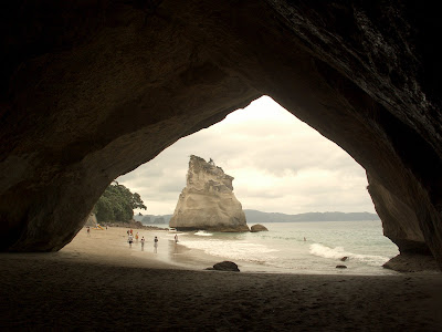
Hahei Beach, start of one of the most famous short treks in NZ, Cathedral Cove. First you hike up a good ways above the beach,

getting views of the headlands you will be passing. There are three coves to descend to, the last of which is the stunner.

It's called Cathedral Cove for this almost gothic sea cave tunnel that looks north to a dramatic rock and pocket beach,


and south to another pocket beach with its own nature-carved statuary offshore.
Cathedral Cove was so stunning, we did the 90-minute r/t walk twice, in the afternoon when we arrived and the next morning before leaving. It's not like we didn't have interesting things to see down the road, however. Just a few miles away is Hot Water Beach. There are some rocks in the center of the beach.

Go to those rocks about 2-3 hours before or after low tide, and start digging, as Jeff is doing, and you have an instant Hot Tub. There are two hot springs directly underneath this one part of the beach, and they are impressively hot, 60C and 64C respectively (140 - 147F). As Jeff dug, it actually became too hot to stand on the near side of the "hot tub".

When the digging was done, some of the folks who agreed to let Jeff help them dig their pool hopped in to enjoy it, staying at the other end from the hot water faucet. It was almost perfect hot tub temperature.
OK, what do you do to top that? Visit a working gold mine. This is the Martha Mine in Waihi,

an underground mine from 1879 until 1952. When the price of gold showed some spunk in the 1970s a group got together to reopen the Martha as an open pit mine, and digging began in 1987. As long as they were mining the Martha, they explored the area nearby and found another promising seam that 19th century miners had missed, and opened an underground mine called the Favona in 2003. The Martha has produced an average of 2,000 ounces of gold and 15,000 ounces of silver a week, since 1988! It's almost played out, but the Favona is running at a similar pace and has quite a few years to go, and they're still poking the ground round and about hoping for another lucky strike.
Close by is Karangahaka Gorge, through which a rail line was pushed to the Waihi gold mines in 1900.

We heard the rail line had been turned into an interesting hiking track, and were not disappointed. Along the way were ephemeral traces of the mining past, such as these ore carts and the Woodstock Battery seen here. Battery not as in "flashlight battery" but rather "assault and battery" --

this is where the gold ore was pounded by "stampers," 40 of them in this one battery alone, crushing gold ore to a flour-like consistency, about 75 tons a day. Then, as now, it is mixed with cyanide to draw off the gold and silver. Various other chemical engineering wonders finally work an amicable separation between the cyanide and the precious metals, and finally pry the gold and silver from each other. And how much rock do you crush to get 1 ounce of gold and 7 ounces of silver? A bit over 4,000 pounds ! The highlight of the trail, however, was the tunnel, 2/3 of a mile long and very dark inside, even with electric ceiling lights every few hundred feet.

Without a flashlight, aiming at the light at the end of the tunnel was just as hard for us as hitting that light at the end of the tunnel was for Lyndon Johnson way back when. Fortunately we had a flashlight, or torch as they call them here, so we survived better than Lyndon did.

Ah, but we were not done. We'd seen gold, but we didn't hit it until our final day, when we did the "Windows Walk." We'll be remembering this one for a long time. Our trek started up the Waitawheta River past yet more batteries, or rather minimal remnants of their concrete footings, then into a series of tunnels that once brought ore down from the 14 levels of mine tunnels dug into Karangahake Mountain that made up the Karangehake gold mine. Miners cut windows in the longest of the rail tunnels not for light, but as a way to dump waste rock into the river just outside the tunnel, to get rid of it quickly. Remember, this was mining. As a critic of strip mining has said, laws making strip mining legal are like a law making rape legal, so long as, when you're done, you return the victim to the condition in which you found her.


Well, the waste rock is now gone, and the tunnels and the views out the windows are stunning, including this view down to a footbridge that takes you over to see the remains of the Underground Battery,

now just a large room carved out of the mountain where the sound must have been deafening when it was filled with stampers a century ago. While that was too big for our camera flash to capture effectively, we did poke down remarkably far in some other mining tunnels for this photo,

about 40 yards from the "windows" tunnel and far enough under the mountain to say "OK, been here, done this," particularly with an unmarked fork in the tunnel system sparking visions of being lost long enough to miss our flight to Australia.

We were mildly astonished to see how much risk-taking the NZ government allows you to take, whether it's wandering into mine tunnels like this or bungy jumping off highway bridges. That said, they did warn us going in, as you can see.

With all this, you'd think we'd be done, but the trail actually continued many miles further. We chose to follow the pipeline track created to bring waterpower to the batteries about two miles upstream,

to where it began at this man-made second channel for the river.

Beyond was a second tunnel that was windowless and a tad tight for tall Jeff, though we did hike all the way through it before deciding we'd gone far enough.

Coming back down the valley, we took the footbridge again and looked up to see the tunnel window we had taken an earlier picture from, cut high on the hillside across the stream, almost invisible in this photo.
Well, it's off to Oz, and we'll have something to report about Australia, or at least Sydney our first stop, when next we write. We'll close with two reminders. First, you can enlarge any photo by clicking on it, then return to the blog with your browser's back button. Try it on some of these photos, you'll be amazed how much better they look. Second, we've gotten a few comments that posed questions we'd like to answer, but unfortunately the format does not provide us with the commenter's email address. Please email us at redtandem@yahoo.com, we'll be happy to write back, though it might take us a week to get to a computer and to have the computer time to respond. Well, for today, G'day, mate!


No comments:
Post a Comment