Friday, August 28, 2009

Biking in Vikingland 3: Out of the Woods, Past the Lakes, and Over the Continental Divide

Hey, hold up you two -- what's this about the Continental Divide? You're in Minnesota, right?

Ya sure, you betcha we are, and yes, there is a Continental Divide, a line dividing waters flowing into two different oceans, that runs right across this state. In this case, between rivers flowing to the Atlantic and rivers flowing to the Arctic!


We crossed the Divide twice, briefly, in the Mesabi, then crossed it twice more in west-central Minnesota. We'll show you the Divide further along in this blog entry.

As our readers will perhaps remember, we headed north the first week of this Minnesota-Wisconsin adventure, then west through the Mesabi the second. Our third week started with a long, long ride down US 2 from Grand Rapids to Cass Lake. The highway was straight and flat for miles, and we only passed one community at mile 15 before hitting the town of Cass Lake at mile 55. We had a strong wind out of the northwest as we headed mostly due west, but managed a respectable 14 mph thanks to the fact that the birch-pine-spruce forest extends quite far westward in the northern part of the state, partially sheltering us from the full brunt of the wind. A measure of how much this took out of us, however, is that we both slept over 10 hours in deep catatonia that night.

We next turned west southwest down the Heartland Trail, a railtrail that was a narrow ribbon of asphalt through the dense forest. Same strong headwinds, but we were so sheltered we averaged over 16 mph. We're really getting to like these bike trails!
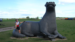
Along the trail we came to a town that claims to the the birthplace of Paul Bunyan, quite an interesting proposition considering he's mythical (but friendly, as you can see!), and then to the Heartland Trail B&B, a former rural schoolhouse where we slept in class -- in the Grade 4 Classroom, to be exact. Very quaint, very comfortable.

The Heartland Trail ended in Park Rapids, a small city twenty miles south of Lake Itasca, where the Mississippi River begins. We were tempted to go see it, Louise for the second time and Jeff for the first, but it was just a wee bit too much off the route we had plotted. As we left Park Rapids, we quickly realized that we were out of the woods. From here to the Dakotas, Minnesota is a mix of prairie and small clusters of oak forest, an environment called an oak savannah. That prairie today is of course almost entirely turned over to crops, primarily corn, soy and hay, sometimes large tracts of one or the other, sometimes all three in close conjunction.
We've put a number of photos here in no particular order, as the views could be where we actually saw them or they could be a hundred miles away -- unless you know that exact spot, you could never tell.

No bike trails here, but the quiet country roads we found were no problem, and some even had remarkably wide shoulders.


Which is not to say the area is without unique and special places. One of them was lodging we happened upon, the Whistle Stop B&B in New York Mills, MN. The town was founded by Finns, and we never did get a good explanation of why they gave it that particular name. A fellow who grew up here and moved to LA came back with his wife to visit some years back, and ended up buying an old Victorian near the tracks and turning it into this charming place. We had a two-room suite upstairs in the house, complete with a bed warming pan as you can see,
and the owner let us take a peek inside one of two palace cars in the side yard that they've restored to 19th century splendor. The B&B's name was ironic, as trains don't stop here anymore, but they do roar by at 50-70 mph and do they ever whistle! All night! We actually slept through quite a few, but got to enjoy some others at odd hours of the night. Well, chalk it up to "romantic atmosphere."


Leaving New York Mills we crossed the Continental Divide -- it's somewhere along this road, although as you can see it would be very hard to pinpoint the exact line.
But cross that mysterious margin we did, and entered the magical world of Ottertail County, which contains over 10% of Minnesota's 10,000 lakes, all 1,000+ of them draining into the Red River of the North and ultimately to Hudson's Bay far to the north.
Those who know these lakes feel each one is unique, based usually on a familiar lake house or fishing resort they've been coming to for years. We needed to tap into these experiences but were challenged to find a way to do so. Most lakes have one or more "resorts," almost always collections of cabins aimed at families with a strong interest in playing on the beach or fishing. But most rent only by the week, and the few we found on the internet that rented by the night had cabins that seemed designed for large extended families and too pricey for just the two of us. Plan B then evolved, and we spent two nights at the Battle Lake Motel in the lakeside community of Battle Lake MN, located 4 miles from Glendalough State Park.

Now this was a special place. The park was a private hunting preserve for almost a century, with the Cowles family of newspaper publishing fame the last owners. It was mainly a family escape but they occasionally entertained guests, including Dwight Eisenhower when he was running for president, and Richard Nixon and Walter Mondale during their vice-presidencies. Today the park contains one lake about a mile in diameter and parts of the shores of two other larger ones, and is maintained by the state in as natural a condition as they can manage.
We rented a canoe both days we visited, and explored the lakes and connecting streams. It was a terrific "vacation from the vacation," complete with loons singing their haunting song to us. It was also nice cross-training for our under-utilized upper body muscles. We truly can steer a canoe, although these photos of us in the bulrushes and cattails might suggest otherwise.


From Battle Lake it was on to Fergus Falls and 90+ miles down yet another of Minnesota's great bike trails. We'll leave that story for next time!

Wednesday, August 19, 2009

Biking in Vikingland 2: Up and Down the Range

This has been a week-plus of ups and downs, topographic and otherwise.

We've been exploring the Mesabi Range, or "The Range" to the locals, who refer to themselves as "Rangers." The first challenge was to get there. We did a short day to the edge of civilization near the Duluth airport, then set out early on lonely US 53, a 4-lane divided highway that goes through no towns whatsoever before reaching the Mesabi. Going for us was a 13 mph wind out of the south, with our destination almost perfectly north. The shoulder turned out to be fairly smooth by northern Minnesota standards -- deep frost makes it almost impossible to keep a road smooth for long, and some are so beat up you need a tank to ride them -- but then the northbound lanes, and their nice wide shoulder, disappeared for 7 miles of construction!
We found an unorthodox solution -- we rode the left shoulder against traffic until the northbound lanes reappeared. We never felt in danger in the construction zone, as there were no roads of any consequence meeting Hwy. 53 in that area, and the shoulder was so wide that we were not at all near the oncoming traffic. Having cars come at us on the right did give us flashbacks of riding in New Zealand, however. We made the 55 miles to Eveleth MN quite easily, thanks to that tailwind, the almost perfectly flat terrain, and the five water bottles that we filled to the brim for this deserted stretch.

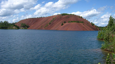
The Mesabi is a range of low hills, few more than 500' above the surrounding valleys so far as we could see, but deep in iron-rich rocks. Mining began a little over a century ago, and continues still, though at a somewhat reduced pace. There are man-made piles of "overburden" all about, rock removed before the rich ore is reached, and many, many pits from played-out mines such as the Leonidas shown here. There was a good viewpoint from one of those overburden piles, which you can see in the foreground as we look at the pit to the north and the town of Eveleth to the east.


Some mines started as underground mines, but the ore was so near the surface that open-pit mining became the norm. Some of the pits have been rehabilitated, such as the wonderfully-named Lake Ore-Be-Gone near Gilbert, with the local boys enjoying safe cliff-diving thanks to the steep surfaces left by the miners.
A short ways away was the Rocheleau group, a pit today that is 2.7 miles long looking north as the result of 14 different mining operations expanding one into the other to create this huge pit.
It got so large that it came to the edge of the city of Virginia MN, where Louise is getting a second and third view of it from the west side.


Although the Mesabi is not a great mountain range, the land is plenty rugged and the Mesabi Trail was one of the hilliest bike trails we've ever ridden.
We took it 80 miles from Eveleth to Grand Rapids MN, and almost half of those miles appeared to be on old railroad lines or mine haulage roads, neither of those stretches altogether flat but at least not steep. Other sections ran up and down hills and around sharp bends, and kept us alert and entertained with their meanderings. It certainly drummed the region's hilliness into us!

Another up and down occurred in Virginia MN. We took the panniers off and left them at our hotel to do a little spin about the city. Jeff thought that the bike felt a little wobbly for an unloaded bike (with panniers on it's always a little bit wobbly!), so he checked the rear wheel and sure enough it was out of true, i.e. wobbly. He got out his spoke wrench to fix the problem and then said a few of those words Dick Nixon said on the Watergate tapes that got censored out. He saw why the wheel was out of true -- the rim was literally ripping apart! (To really see what we're talking about, click on the photo to enlarge it, and look at the grommet hole on the left, with two rips in the rim surface above and below the grommet and two smaller rips headed out to meet them)

We found a bike store in the yellow pages and rode over. After a lot of searching around his storeroom, Nick the mechanic finally found a slightly used rim that was the correct size and number of spokes (they come in 28, 32, 36, 40 and 48-spoke models, though ours was the commonest at 36). Nick was even willing to get right on the job of rebuilding the wheel, and we actually had a phone call less than two hours later telling us that the wheel was done! We walked over in the morning and our tandem was once again safe to ride. Close call! Many thanks to Nick!!!
BTW, our stay in Virginia coincided with a classic car weekend, and we got quite a display of them both parked and cruising up and down Main Street. The next morning as we left town, Main Street was closed to all traffic and classic cars were parking almost fender-to-fender in the middle of the street, two columns of them stradling the center line and stretching 6 or 7 blocks.


Back on the trail, we enjoyed the deep woods of pine and birch,
and appreciated how much they protected us from winds that would have been stiff headwinds out on the plains. Just outside Hibbing we came to the largest mine pit of all, known today as the Hull-Rust-Mahoning but actually a consolidation of 30 different pits.

It gets as deep as 600' in one area, and is so massive they've dubbed it "The Grand Canyon of the North." Nearby was some of the equipment, which Jeff modeled for size. The operator of that monster truck described it as like driving a two-story house from the attic.

The mine was particularly successful while it was mining hematite that was as much as 60% pure iron.
During WW II this single large pit provided 25% of all the iron used in the U.S., at a time when aircraft carriers, Liberty ships, tanks, and many other things created an unusually heavy demand for this metal! The hematite ran out in the 1980s, and what's now mined is 30-35% iron. It is concentrated into little pellets called "taconite." Mined, that is, when there's not a recession going on. This mine laid off about 800 employees last year, and it's not clear how soon they'll be called back. Another large operation further north has started calling back some of its laid-off employees, so there's some hope yet for Hibbing.

As the mine started spreading out a century ago to get all the ore, it turned out that the town of Hibbing lay over some of the good stuff. The mine company moved the whole town two miles south. In this second photo of the pit, the first quarter mile of air is where the town used to be!
The building that is today the Mitchell-Tappan House B&B took the amble southward, and was far from the largest building moved. We stayed there, and it was a terrific B&B. Owner Pam made us right at home.

We ended up staying an extra night in Hibbing, partly because of the great B&B, and partly because the next day was fairly stormy. Two women riding the Mesabi Trail in the opposite direction did leave, and we're pretty sure they got drenched about a half-hour later, though most of the day was just threatening. Thing about getting drenched, though, it kind of lasts the rest of the day when you only have one outfit for biking. Call us "rain wimps," but we do try very hard to not get soaked.

With time on our hands, we enjoyed reading on the sun porch and then walked to the Greyhound Bus Museum.
Yes, Greyhound as in the monolithic bus company that almost all of you our readers have taken some time in your life. It started here in Hibbing with a car dealership that wasn't selling cars, but had a lot of people wanting to take "test drives" that weren't turning into sales. The owners decided to take one of the cars and offers rides to and from the mines, about 2 miles, for 15 cents. It was so successful they put more cars into it, then started stretching the cars much like today's stretch limos, then buying buses that got larger and larger and ... well, the Greyhound Company resulted.


We also swung by a nondescript house a family moved into in 1948 when their boy, Bobby Zimmerman, was 7 years old. He lived there until he left for college. Soon after that he changed his name to the one you probably recognize: Bob Dylan.


Back on the trail, we met another couple that inspired us, Bob and Gerry who are 14 years older than the each of us and still cycling. Like us, they came to Minnesota from far off -- in their case Florida -- to ride these wondeful bike trails. After passing one last but very impressive pile of overburden, we finished the Mesabi Trail in Grand Rapids MN,
so-named because of the rapids that prevented further steamboat travel up the Mississippi River. We had another comfortable stay at the Morning Glory B&B before heading west on US 2 to cross the fabled Mississippi itself. This far north, however, it's more of a stream!

Now that we're west of the Mississippi, it seems like a good time to sum up and leave the lakes and plains of western Minnesota for the next blog entry. Talk to you next from somewhere down the road in west-central Minnesota!

Sunday, August 2, 2009

Biking in Vikingland 1: Starting out

Thank goodness book titles are not copyrightable. Jeff found a book on biking Minnesota and Wisconsin some years ago, and the catchy title so impressed him that he's bestowed that moniker on our latest tandem adventure, Biking in Vikingland.

These two states are loaded with bike trails, mostly converted from abandoned rail lines but some with other origins. Planning started with a notice in Doubletalk, the newsletter of the Tandem Club of America, that the Midwest Tandem Rally (MTR2009) would be held Labor Day weekend in Rochester Minnesota. Hey, we have nothing planned for Labor Day, or in fact for a few weeks before or after -- (ain't retirement great?) -- and we had extremely fond memories of biking through this area in 2003. A little web research came up with a map showing just how many bike trails there are in Minnesota, and in short order we had sketched out the trip you see here. Bike trails are in red, wide red lines are ones we're going to ride on, and wide green lines represent road miles between bike trails. Since the vast majority of those road miles are on back roads -- county roads or low-traffic-density state highways -- relaxed riding is hopefully going to be the order of the day. Just start in St. Paul, head north, head west, head south, and eventually reach Rochester in the SE corner of the state!


OK, what about after the Tandem Rally? The grandaddy of American Rail Trails is the Elroy-Sparta Trail in Wisconsin, which Jeff cycled in 1971, Louise in 1994, and both of us enjoyed together on the tandem in that 2003 trip. So while planning the new trip, it was natural to ask, how about another ride on this great trail, through 3 tunnels and across the unglaciated beauty of the so-called "driftless area" of Wisconsin?

Finally, we mentioned our plans to Don and Erica, tandem friends from Victoria BC. They were the chief organizers of the Northwest Tandem Rally held this year in their town (it rotates around the Pacific NW each year). Their "reward" for all their hard work was not being able to ride at their own rally -- just too much to do! The MTR2009 sounded like a great idea, since they obviously do enjoy tandem rallies, and their interest was piqued even more when they heard about all the rail trails and back roads. Erica still works, however, so they could not join us for the entire adventure. Instead, they'll catch up with us at the Rally and team up for the last 2 ½ weeks, riding out the SE corner of Minnesota and into Wisconsin. We won't be taking in so large a percentage of Wisconsin's many bike trails, but we will be on bike trails for over 50% of our miles in that state. In the Wisconsin map below, bike trails are in green and road miles are in black, going from La Crosse on the Mississippi to Milwaukee on Lake Michigan, coming in on Hank Aaron Trail.


And so on August 2nd we set out on our favorite long-distance carrier, Amtrak, specifically on the Empire Builder that runs from Seattle to Chicago via the Twin Cities, where we disembarked. Don & Erica will hop off two stops further down the line when they head to the rally, and Milwaukee is where we'll all reboard for the train ride home. Amtrak is quite bike-friendly, and we're so used to the routine that it all went quite smoothly and it seemed like no time before we were sliding the tandem out of the cardboard box that Amtrak provides, ready to ride. We've taken the Empire Builder so many times -- for Jeff, over a dozen -- that it seems almost like a commute, albeit a pretty scenic one with the Cascades and Rockies, the Columbia and the Mississippi, and the vast expanses of Montana and North Dakota plains.

We had previously seen quite a bit of Minneapolis, the bigger twin of the Twin Cities, so this time we focused on St. Paul, and liked what we saw. Besides visiting friends Stuart and Carole from the cruise, we tootled 80 miles around town on our tandem, and 50 of those were on bike trails! Try doing that in other cities this size! Highlights were a trail along the Mississippi, complete with grain barges and a steamboat; Fort Snelling at the confluence of the Minnesota and Mississippi Rivers, a place that has guarded this spot for over 150 years; and a tour of the home of James J. Hill, known as the Empire Builder for his success in bringing the Great Northern Railroad, and civilization, across the northern plains all the way to Seattle. It was a big house for a short fellow with a big family -- 10 kids, each of whom got his or her own bedroom -- and even bigger ambitions. We would dearly love to show you some of this as well as tell you about it -- we know you only read this for the pictures, to turn a phrase -- but an SD card in our camera that served us well in NZ has not liked the transition to the northern hemisphere, and gone bad. It deleted a few shots without being asked to, then shut down entirely.

So the visual part of our bike trip will have to start with a canoe trip! After the grand tour of St. Paul, we rode 25 miles east to Stillwater, a quaint town on the St. Croix River that forms the boundary between MN and WI for about 150 miles. Next day we waited out a morning rain for a 30-mile ride up to Taylor's Falls, not a great distance but challenging due to the road's frequent undulations up and down the steep sides of the St. Croix valley. At Taylor's Falls we took a day off the bike for a seven-mile one-way canoe trip, with a few hundred folks with similar ideas, and others with even less strenuous ways of seeing the river. It's the same price whether they pick you up there or at the next take-out at 17 miles, but with a modest current and a fairly strong headwind, we were more than happy to hang up the paddles at 7 miles and enjoy the bus ride back.


Minnesota began to be settled in earnest in the 1850s, and Taylor's Falls has the oldest schoolhouse in the state, dated 1852. A day and a half's riding from there brought us to Hinkley, a town that became infamous in 1894 for a massive fire that in 4 hours on September 1 destroyed 480 square miles and killed about 450 people. The Hinkley Fire Museum in the rebuilt train depot had a film, photos and artifacts, and this wonderful diorama of the way the town looked just before the fire. Everything you see here burned to nothing, as this was a firestorm, a fire so large it created its own cyclonic winds, estimated to have exceeded 75 mph. It's said that the US and British Air Forces studied this and a handful of other naturally-occurring firestorms, generally caused by drought and aggravated by foolish lumbering practices that hit various parts of the midwest a century ago, when they set about intentionally creating ones in Germany and Japan during WW II, such as those in Dresden and Tokyo.

We left Hinkley on the same rail line that brought another 400 people to safety by such a narrow margin that a trestle they crossed was already burning as they started across, and collapsed just after they made the far side. Telegrapher Tom Dunn, depicted in this diorama back at the Fire Museum, stayed on to keep information flowing to the outside world, and his last message was "I think I've stayed too long." He had.

Today the rail line is the Munger State Trail, and what a wonderful ride this was! It carried us 70 miles, all the way to Duluth, every one of those miles paved and remarkably smooth. There was a fairly stiff side wind, but forests in places and a line of trees and bushes next to the trail in more open areas kept the side wind to a minimum. Except for a few small towns, some like this one with the old train station intact, we mostly enjoyed seeing regenerating pine forests and farms growing corn and soy.

The first 60 miles were quite flat, tenths of a percent grade at most. Soon after crossing the chasm of the St. Louis River and cutting a path through some rugged basalt outcroppings, however,
we started a rewarding descent to Duluth at a steady 1 percent, not quite enough to coast but steep enough to allow us to move along at over 20 mph with minimal pedaling effort. Well before this we had commented to each other how good it felt to be back on the bike and touring on our own power. The beauty and serenity of the Munger Trail quadrupled that feeling.

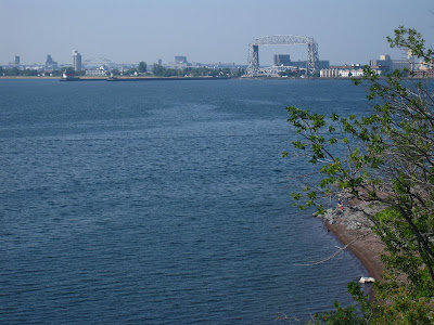
As the Space Needle is to Seattle and the Arch to St. Louis, the Lift Bridge is to Duluth. This massive structure bridges the Canal, a piece of water with quite a history. A sand spit stretches 7 miles out from Duluth, almost touching another spit that comes out from the Wisconsin shore. The beach you see pictured is about 5 miles out from town on Minnesota Spit, at Duluth's favorite swimming place today.
Boats first tried docking outside Minnesota Spit, but fierce storms -- one of them sunk four boats -- convinced folks that the harbor really needed to be behind the spit. But ships going that far from Duluth to get around the spit would be tempted to stop instead in the twin city of Superior Wisconsin. Duluth folks started to dig a channel at the base of Minnesota Spit. Wisconsin folks headed to federal court and obtained an injunction to stop them, but they got it on a Friday afternoon and the marshall said he couldn't serve it until Monday. It was a really busy weekend in Duluth, as you can imagine, and the Canal was a fait accompli of course by Monday morning.

Duluth is a working town, with a modest and uninspiring downtown but a busy, busy harbor. Ship after ship after ship sails in or out through that canal, loaded usually with wheat from the vast plains of North Dakota and Montana, coal from the Powder River basin of Wyoming, or taconite, a type of partially refined iron ore, from the Mesabi Range about 70 miles to the north of Duluth. We enjoyed a half-day walking the wonderful Lakefront Trail and watching a tai chi class in action,
then turned the bike northwards to see the Mesabi ourselves. We have a half-day ride to the edge of civilization up near the airport, then our longest day of the trip, about 67 miles we think, to the first town with lodging, Eveleth. From there we'll ride the hilly Mesabi Bike Trail 80 miles through the greatest iron deposits in North America. Tell you more about it in our next blog.

Sleeping in Seattle


We're back! In 22 months on the road following retirement and that wonderful cake Jeff's office presented, we've tandemed over 8,000 miles, walked 3,000 miles each, and taken the Volendam a whopping 30,000 miles (10,000 to New Zealand and 20,000 on our much more circuitous route back). Then add in 11,000 miles on trains in the US, NZ, Australia and Japan plus 7,500 air miles for three round trip hops (Seattle-Tokyo for Matt's wedding at the very beginning of our journey, Miami-Austin TX mid-way through for Becky's wedding, and New Zealand-Australia for the heck of it in late '08/early '09), and that's enough mileage to circle the earth two and a half times! Considering that we covered over 180° of longitude from Maine to Thailand and hit points from 59° N latitude in Alaska to 46° S in New Zealand, we certainly felt like we'd been around the world more than a few times!

The touch-screen map in the Ship's Library said "Vancouver," the sails of Canada Place next to the Volendam said "Vancouver!" and the Lion's Gate Bridge now behind us said "VANCOUVER!!!" We must be in Vancouver, eh?


With a remarkably easy run through Canadian Customs, a short walk through downtown to pick up a rental car we had reserved, and a drive of 140 miles with another surprisingly easy passage through American Customs, it was home again at last. Home Sweet Empty Home. But within 2 days a moving van arrived with the rest of our worldly possessions from the public storage unit they had occupied while renters used our condo. Thanks to some obsessive-compulsive cleaning and unpacking, we had the place looking like its old self within 48 hours, with even the 60 moving cartons gone thanks to the magic of the "Free Stuff" section of CraigsList.com!


What next for us, and for the blog? Unlike some netizens, we are not going to document the rest of our lives online. However, we are going to write a few more blog entries over the next 7 weeks as we get back to our main love and tandem around Minnesota and Wisconsin. Ah, yes, although the ship landed in Vancouver on May 20 it has taken until early August to finish the story of our 22-month adventure, and the new one begins in a few hours when we board Amtrak for the familiar trip east in a sleeping car on the Empire Builder. Those two states are among the best in the nation for rail-trails, and we anticipate using bike trails for over 500 of the 1300-or-so miles we'll cover. For added fun, we'll be attending the Midwest Tandem Rally in Rochester Minnesota, and our friends Don and Erica from Victoria BC will join us for the Rally and for 2½ weeks of riding those wonderful bike trails and back roads with us. So stay tuned, more to come, at least for a short while! And thanks for following our adventure so far!