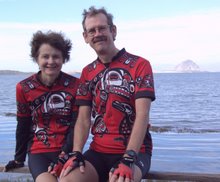
Haast Pass was a beautiful ride, but a bit harder than we expected. Amazing how much bigger and steeper the pass got since Louise rode over it with her daughter Lisa 15 years ago, even starting 30 km closer to the pass this time! Our ride began in the town that is the last place to get food or water for the next 80 km, Haast. We filled up every available water bottle, carried a bottle of juice, and brought along a can of pears for extra liquid as well as energy, and hydration was not an issue. Temperatures of 20-22 C (68-72 F) helped, and we even had a very light tailwind, not enough to push us along but at least not a hindrance. The first 50 km followed the wide Haast Valley,

mostly flat with occasional short rises we could do without getting into the granny gear, passing stunning waterfalls every few miles,

many descending 50 to 100 m in freefall from the glacially carved side of our valley. At lunch we had done 50 of our 80 km, but only 100 of the 563 m of climbing that had to be done.
The first physical challenge, however, was not the climb after lunch, but simply getting through lunch undevoured by the sandflies. The technique was to eat standing and holding the food with one hand, keeping the other hand and both legs free for sandfly control. Somehow we managed to free up a hand to take a shot of the gorgeous setting. It was certainly one of the most athletic lunches we've ever had!

Soon after the lunch break we were at the Gates of Haast, where the climb really started to bite. The road barely hung onto the side of the hill as it rose up at a more than 10% grade, and kept it up for 2-3 km.


It was time for our special weapon, "28th gear"

(an old joke explained many, many blog entries ago -- suffice it to say, the bike itself has 27 gear choices). Finally the climb relented into a manageable 1 or 2% grade, though still twisty as all get-out,


and at last we reached the summit, which had gained a meter from the 563 advertised elsewhere. On the way down we looked back for one view,


and stopped a second time for a very rewarding 20-minute hike to the Blue Pools, which were as advertised.
All in all, we felt fairly good about the day, tired as we were. The next day was 65 km to the town of Wanaka, past the upper reaches of Lake Wanaka and then over "the Neck" to nearby Lake Hawea. That's Lake Wanaka in the first shot, and again behind Louise, who's at the top of the Neck in the second.


Lake H wasn't quite as large but was just as impressive as Lake W, and quite moody in the fourth picture.


Although we had a tail wind most of the ride, up to 25 mph/40kph for a few glorious kilometers at the start of the day, it was a very tough day due to the climbing. We had booked 2 nights in Wanaka because Louise remembered it as a lovely town, and it is, but we mostly used the extra day to regain the will to live. Well, maybe that exaggerates a tad, but we were dog-tired! Nonetheless, we did do a short walk to the lake to capture the stunning view to the north from its little beach.


Since crossing Haast Pass we have been east of the Southern Alps, i.e. leeward of the moist Tasman Sea winds that drench the west side of the mountains. We kept remarking to each other how much it reminded us of the mountains around Wenatchee or Lake Chelan in our native Washington State, or of places we've seen east of the Rockies, such as in Montana.

When we got to Cromwell, which at 400 mm of rain a year is drier even than Wenatchee, we rested in Old Cromwell, a street made up of buildings rescued from the rising waters when the Clutha Valley was dammed for hydro about a decade ago. Ironically, rain caught up with us here the next morning, in one of the driest places in New Zealand, after we had successfully dodged it through the wet Westland! Well, rain wimps that we are, we hung out in the town library and then in a cafe until 2 pm, when the rain had passed on, and kept our rainjackets unused once again.

We were now 70 km from Queenstown but decided to break it up into 50 km and 20 km segments to spend a night in quaint Arrowtown, yet another gold rush town but almost certainly the most well-preserved. There is a small downtown with the old post office, assay office

and town shops now selling woolens and jade jewelry (NZ's most precious stone, also called pounamou from the Maori) plus the sorts of things that upscale boutiques sell everywhere you find them.

Arrowtown also has rescued what is now called The Chinese Settlement, a part of town where Chinese goldminers once lived segregated from the rest of town, but with the advantage of having a Chinese store and a community of kinsmen to help deal with being strangers in a strange land. In 1983 the government sponsored an archeological dig and restoration of some of the remaining buildings, and informative signs along a short walk helped explain why they came, how they lived, and how they came to drift away. The building Louise is peeking in and the one two over were homes, the one in between was a storage shed of some sort.

There were many other interesting walks we would have liked to do in Arrowtown but for the limits of time, and this is one place we will return to if or when we get back to New Zealand.

Finally we were on the road our bike book told us was "relatively flat" from Arrowtown to Queenstown. The book also didn't predict the headwind, so it was a pretty tough 24 km ride, but that's only 15 miles, and at last we were at our destination! As we mentioned in our last blog entry, this is the "adventure capital" of NZ, and in fact on the way between Cromwell and Arrowtown one day earlier we passed the place where it all started. The Kawarau Gorge is -- well -- gorgeous,

and in the early 1980's an enterprising young nut came up with the idea of jumping off an abandoned bridge in the gorge with elastic bungy cords attached to his feet. Not quite sure how he turned this into a business empire, let alone survived the world's first bungy jump, but it was already a Big Deal in 1994 when Louise's daughter Lisa took the plunge. That was on a hot late-summer day. On this revisit it was 17C/63F, and was clouded over. But in the course of a 25-minute stop we watched 3 women and 2 men jump off the darned thing.


Five of those minutes were occupied in watching an employee "talk down" a customer, pardon the pun, and for a while we weren't sure she was going to jump, but sure enough she joined the rest of 'em in leaping off.

Don't know if it was peer pressure or thinking "Golly, I just plunked down over US$80 for this thing, I might as well do it!"

BTW, after you stop bouncing, they add extra cord to lower you into a nearby boat to get reeled in, where for a few moments you are truly "Down Under!"
We referenced three challenges in the title of this entry, and the first challenge was one we felt we had met enough of as we rode into Queenstown. The climbing and the miles were starting to get to us, and the route ahead should we choose to continue southward was going to get far more remote, and be far from flat. We decided Queenstown was an honorable final biking destination, and the 1100 km we rode to get here were something we could feel good about. We headed into town to get some cash to help celebrate, and ran smack into challenge number two.
To understand what happened next, you have to remember that living on the road for almost two years poses some challenges. One of them is what to do about mail. Most of the folks who used to mail us important things like credit card statements now email them to us. But you have to have mail go somewhere, so we chose the home of one of our children, and the mail collects there quite nicely. We went through it twice last year when visiting, and there was virtually nothing that we didn't already know about, and the rest was stuff we didn't need to know about.
However, an unassuming letter reached this destination sometime since last September, containing a debit card from our bank to replace the atm card we carried with us, since our bank had decided to phase out the atm card. Well ... they put an instruction into the worldwide atm system that the card should be collected by any atm it got inserted into after such-and-such a date. Seems that date went by recently, and one of the atms in Queenstown did as instructed, and swallowed our card!
Yowp!!! NOW what do we do??? In fact, for the next unsettled 12 hours, until it was daytime in Seattle, we didn't even know why the card was taken. All we knew was the atm message: "contact your bank." The bank reassured us next morning that all was well with our account, figured out why the card had disappeared, and gave us a number to call for Visa Card Services. Long story short, we will have a new temporary debit card delivered to a hotel we're staying at a week from now.

In the meantime, before we commit to anything that costs money, we ask first if they accept credit cards, so we can save the few dollars of cash we have left in the wallet for emergency use. And, with our credit card, we did enjoy a nice Korean feast for Valentine's Day!
Which leads us to the final challenge, putting together an itinerary for the remaining 30 days we will be in NZ. We had previously planned the last week, just prior to when we reboard the Volendam, so that meant working out the remainder and making the necessary bookings. It's just astounding how much time and effort it takes to do this, but after reworking the plans umpteen different ways, then changing them a few more times, we've settled on renting a car and driving somewhat further south to Te Anau and Fiordlands National Park, then north to Abel Tasman National Park at the other end of South Island, with a number of interesting stops en route. We'll explain the route and maybe even have a map in the next blog, not to mention what we hope will be some terrific pictures from the deep, remote fiords of New Zealand's southwest coast. We'll close with a shot of our British tandem friends Lin and Bernard, 
who have circled the South Island in the opposite direction from us and met us again here in Queenstown, and of the mountain range just southeast of town with the wonderful name of "The Remarkables."


who have circled the South Island in the opposite direction from us and met us again here in Queenstown, and of the mountain range just southeast of town with the wonderful name of "The Remarkables."